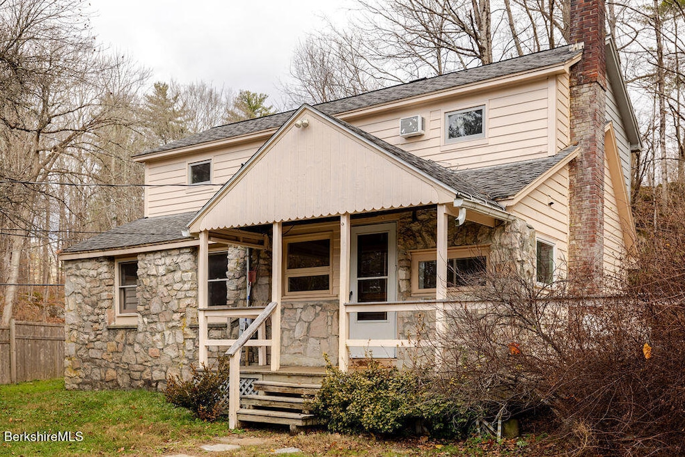
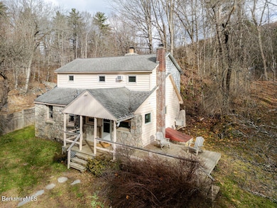
26 Lenox Rd West Stockbridge, MA 01266
Estimated payment $2,643/month
Highlights
- Deck
- Wood Flooring
- Fenced Yard
- Monument Mountain Regional High School Rated A-
- Cottage
- Fireplace
About This Home
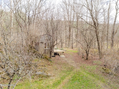
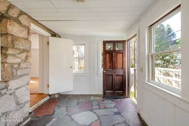
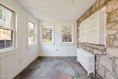
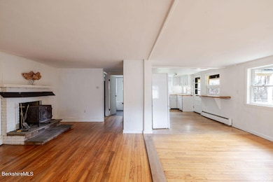
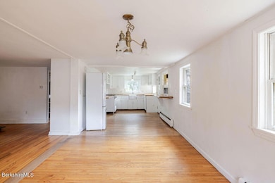
1900's cottage set above the village of West Stockbridge. Open plan living with updated kitchen and bath, with laundry tucked in below the stairs and second floor has three bedrooms. Fenced yard creating a nice private space with wraparound deck. Shed at the back of the property providing a lovely additional space.
Home Details
Home Type
- Single Family
Est. Annual Taxes
- $5,159
Year Built
- 1900
Lot Details
- 0.53 Acre Lot
- Fenced Yard
Home Design
- Cottage
- Wood Frame Construction
- Asphalt Shingled Roof
- Clap Board Siding
- Masonry Siding
- Clapboard
Interior Spaces
- 1,269 Sq Ft Home
- Fireplace
Kitchen
- Range
- Dishwasher
Flooring
- Wood
- Ceramic Tile
Bedrooms and Bathrooms
- 3 Bedrooms
- 1 Full Bathroom
Unfinished Basement
- Partial Basement
- Dirt Floor
Parking
- No Garage
- Off-Street Parking
Outdoor Features
- Deck
- Outbuilding
Schools
- Muddy Brook Reg. Elementary School
- Monument Valley Reg. Middle School
- Monument Mountain High School
Utilities
- Hot Water Heating System
- Boiler Heating System
- Heating System Uses Oil
- Electric Water Heater
- Private Sewer
- Fiber Optics Available
- Cable TV Available
Map
Home Values in the Area
Average Home Value in this Area
Tax History
| Year | Tax Paid | Tax Assessment Tax Assessment Total Assessment is a certain percentage of the fair market value that is determined by local assessors to be the total taxable value of land and additions on the property. | Land | Improvement |
|---|---|---|---|---|
| 2025 | $4,814 | $500,400 | $79,500 | $420,900 |
| 2024 | $3,805 | $397,200 | $70,500 | $326,700 |
| 2023 | $3,482 | $337,700 | $67,100 | $270,600 |
| 2022 | $3,166 | $252,100 | $67,100 | $185,000 |
| 2021 | $1,899 | $192,900 | $67,000 | $125,900 |
| 2020 | $2,531 | $192,900 | $67,000 | $125,900 |
| 2019 | $3,563 | $193,200 | $67,000 | $126,200 |
| 2018 | $3,544 | $193,200 | $67,000 | $126,200 |
| 2017 | $1,820 | $193,200 | $67,000 | $126,200 |
| 2016 | $2,382 | $193,200 | $67,000 | $126,200 |
| 2015 | $2,287 | $193,200 | $67,000 | $126,200 |
| 2014 | $2,148 | $193,200 | $67,000 | $126,200 |
Property History
| Date | Event | Price | List to Sale | Price per Sq Ft |
|---|---|---|---|---|
| 11/22/2025 11/22/25 | For Sale | $419,000 | -- | $330 / Sq Ft |
Purchase History
| Date | Type | Sale Price | Title Company |
|---|---|---|---|
| Not Resolvable | $185,500 | -- | |
| Deed | $110,000 | -- |
Mortgage History
| Date | Status | Loan Amount | Loan Type |
|---|---|---|---|
| Open | $180,500 | New Conventional | |
| Previous Owner | $125,000 | No Value Available | |
| Previous Owner | $86,000 | No Value Available | |
| Previous Owner | $88,000 | Purchase Money Mortgage |
Source: Berkshire County Board of REALTORS®
MLS Number: 248317
APN: WSTO-000101-000000-000047
Disclaimer: Certain information contained herein is derived from information provided by parties other than Homes.com. All information provided is deemed reliable, but is not guaranteed to be accurate and should be independently verified.
![]() IDX information is provided exclusively for consumers' personal, non-commercial use, that it may not be used for any purpose other than to identify prospective properties consumers may be interested in purchasing. Information deemed to be reliable but not guaranteed.
IDX information is provided exclusively for consumers' personal, non-commercial use, that it may not be used for any purpose other than to identify prospective properties consumers may be interested in purchasing. Information deemed to be reliable but not guaranteed.
The data relating to real estate for sale on this website comes from Berkshire County Board of Realtors and the Broker Reciprocity Program.
Copyright 2025 Berkshire County Board of Realtors. All rights reserved.
- 16 Swamp Rd
- 29 Main St
- 35 Main St
- 45 Swamp
- 21 Stockbridge Rd
- 19 Washington Square
- 7 Silver Mine Ln
- 76 Lenox Rd
- 17 Iron Mine Rd
- 0 Lenox Rd Unit 246122
- 51 Albany Rd
- 30 Great Barrington Rd
- 2650 Swamp Rd
- 0 Furnace Rd
- 206 Stevens Glen Rd
- 1 Old Tree Farm Rd
- 2801 State Rd
- 1310 Lenox Rd
- 2200 Swamp Rd
- 2507 State Rd
- 1292 Lenox Rd Unit 1
- 230 Middle Rd
- 208 Cunningham Hill Rd
- 68 Kemble St
- 34 Church St Unit 2B
- 109 Housatonic St
- 2 Depot Rd
- 66 Brushwood Way
- 165 Stockbridge Rd
- 207 Pleasant St
- 121 Queechy Lake Dr
- 1579 Pleasant St
- 1579 Pleasant St
- 1579 Pleasant St
- 73 W Center St
- 125 Center St Unit 2
- 1-6 Meadow Ln Unit 7-4
- 703 W Housatonic St
- 12 Applewood Ln Unit 12
- 99 Hawthorne Ave
