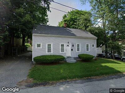
26 Main St Auburn, MA 01501
Stoneville NeighborhoodEstimated Value: $337,000 - $369,000
3
Beds
2
Baths
1,180
Sq Ft
$298/Sq Ft
Est. Value
About This Home
This home is located at 26 Main St, Auburn, MA 01501 and is currently estimated at $351,115, approximately $297 per square foot. 26 Main St is a home located in Worcester County with nearby schools including Auburn Senior High School, Canterbury Street School, and Shrewsbury Montessori School - Auburn Campus.
Ownership History
Date
Name
Owned For
Owner Type
Purchase Details
Closed on
Mar 28, 2018
Sold by
Kim Sunnie and Kim Donald
Bought by
Marengo Michael D
Current Estimated Value
Home Financials for this Owner
Home Financials are based on the most recent Mortgage that was taken out on this home.
Original Mortgage
$170,335
Outstanding Balance
$145,859
Interest Rate
4.38%
Mortgage Type
New Conventional
Estimated Equity
$237,584
Purchase Details
Closed on
Nov 2, 2016
Sold by
Kim Sunnie and Kim Donald
Bought by
Marengo Michael D
Home Financials for this Owner
Home Financials are based on the most recent Mortgage that was taken out on this home.
Original Mortgage
$170,335
Interest Rate
3.48%
Mortgage Type
New Conventional
Purchase Details
Closed on
Dec 14, 2011
Sold by
Cullinan Roy B
Bought by
Kim Sunnie
Create a Home Valuation Report for This Property
The Home Valuation Report is an in-depth analysis detailing your home's value as well as a comparison with similar homes in the area
Home Values in the Area
Average Home Value in this Area
Purchase History
| Date | Buyer | Sale Price | Title Company |
|---|---|---|---|
| Marengo Michael D | $179,300 | -- | |
| Marengo Michael D | $179,300 | -- | |
| Kim Sunnie | $300,000 | -- |
Source: Public Records
Mortgage History
| Date | Status | Borrower | Loan Amount |
|---|---|---|---|
| Open | Marengo Michael D | $40,000 | |
| Open | Marengo Michael D | $170,335 | |
| Closed | Marengo Michael D | $15,000 | |
| Previous Owner | Marengo Michael D | $170,335 |
Source: Public Records
Tax History Compared to Growth
Tax History
| Year | Tax Paid | Tax Assessment Tax Assessment Total Assessment is a certain percentage of the fair market value that is determined by local assessors to be the total taxable value of land and additions on the property. | Land | Improvement |
|---|---|---|---|---|
| 2025 | $42 | $294,000 | $109,500 | $184,500 |
| 2024 | $4,573 | $306,300 | $103,300 | $203,000 |
| 2023 | $4,535 | $285,600 | $93,900 | $191,700 |
| 2022 | $4,286 | $254,800 | $93,900 | $160,900 |
| 2021 | $3,933 | $216,800 | $82,900 | $133,900 |
| 2020 | $3,758 | $209,000 | $82,900 | $126,100 |
| 2019 | $3,655 | $198,400 | $82,100 | $116,300 |
| 2018 | $3,397 | $184,200 | $76,700 | $107,500 |
| 2017 | $3,441 | $187,600 | $69,600 | $118,000 |
| 2016 | $3,298 | $182,300 | $71,400 | $110,900 |
| 2015 | $3,103 | $179,800 | $71,400 | $108,400 |
| 2014 | $3,027 | $175,100 | $68,000 | $107,100 |
Source: Public Records
Map
Nearby Homes
- 177 Oxford St N
- 19 Zabelle Ave
- 19-20 Williams St
- 62 Rockland Rd
- 4 Marie St
- 5 Commonwealth Ave
- 33 Walsh Ave
- 31-33 Walsh Ave
- 31 Walsh Ave
- 88 Wallace Ave
- 16 Carroll St
- 6 Mayfield Rd
- 105 Rochdale St
- 56 Chestnut Ave
- 31 Bylund Ave
- 53 Burnett St
- 4 Murray Ave
- 52 Harrison Ave
- 1403 Forest Park Dr
- 20 Briarcliff Dr
- 26 Main St
- 26 Main St Unit 1
- 24 Main St
- 200 Auburn St
- 200 Auburn St Unit 1
- 29 Main St
- 192 Auburn St Unit 2
- 18 Main St
- 999 Main St
- 25 Main St
- 188 Auburn St Unit 1
- 188 Auburn St
- 188 Auburn St Unit 2
- 195 Auburn St
- 1 Francis St
- 16 Main St
- 191 Auburn St Unit 193
- 191-193 Auburn St
- 191-193 Auburn St Unit A
- 8 Beverly Rd