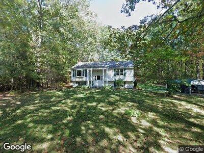
26 Mossman Rd Westminster, MA 01473
Estimated Value: $396,000 - $529,000
2
Beds
2
Baths
1,092
Sq Ft
$401/Sq Ft
Est. Value
About This Home
This home is located at 26 Mossman Rd, Westminster, MA 01473 and is currently estimated at $437,955, approximately $401 per square foot. 26 Mossman Rd is a home located in Worcester County with nearby schools including Oakmont Regional High School and Wachusett Hills Christian School.
Ownership History
Date
Name
Owned For
Owner Type
Purchase Details
Closed on
May 10, 2021
Sold by
Bastarache Edward J
Bought by
Edward J Bastarache Ft
Current Estimated Value
Purchase Details
Closed on
Jan 30, 2017
Sold by
Bastarache Edward J and Bastarache Maria
Bought by
Bastarache Edward J
Purchase Details
Closed on
Dec 7, 1987
Sold by
Gravelle Frank J
Bought by
Bastarache Edward J
Home Financials for this Owner
Home Financials are based on the most recent Mortgage that was taken out on this home.
Original Mortgage
$105,000
Interest Rate
11.27%
Mortgage Type
Purchase Money Mortgage
Create a Home Valuation Report for This Property
The Home Valuation Report is an in-depth analysis detailing your home's value as well as a comparison with similar homes in the area
Home Values in the Area
Average Home Value in this Area
Purchase History
| Date | Buyer | Sale Price | Title Company |
|---|---|---|---|
| Edward J Bastarache Ft | -- | None Available | |
| Bastarache Edward J | -- | -- | |
| Bastarache Edward J | $140,000 | -- |
Source: Public Records
Mortgage History
| Date | Status | Borrower | Loan Amount |
|---|---|---|---|
| Previous Owner | Bastarache Edward J | $150,000 | |
| Previous Owner | Bastarache Edward J | $100,000 | |
| Previous Owner | Bastarache Edward J | $28,000 | |
| Previous Owner | Bastarache Edward J | $35,000 | |
| Previous Owner | Bastarache Edward J | $30,000 | |
| Previous Owner | Bastarache Edward J | $105,000 |
Source: Public Records
Tax History Compared to Growth
Tax History
| Year | Tax Paid | Tax Assessment Tax Assessment Total Assessment is a certain percentage of the fair market value that is determined by local assessors to be the total taxable value of land and additions on the property. | Land | Improvement |
|---|---|---|---|---|
| 2025 | $4,122 | $335,100 | $120,900 | $214,200 |
| 2024 | $3,966 | $323,500 | $120,900 | $202,600 |
| 2023 | $3,889 | $297,800 | $111,000 | $186,800 |
| 2022 | $3,753 | $237,500 | $96,600 | $140,900 |
| 2021 | $5,016 | $222,500 | $86,100 | $136,400 |
| 2020 | $3,621 | $206,300 | $78,100 | $128,200 |
| 2019 | $3,639 | $199,400 | $64,500 | $134,900 |
| 2018 | $3,576 | $192,800 | $64,500 | $128,300 |
| 2017 | $3,409 | $187,400 | $64,500 | $122,900 |
| 2016 | $3,365 | $179,200 | $53,600 | $125,600 |
| 2015 | $3,371 | $177,900 | $53,600 | $124,300 |
| 2014 | $3,377 | $177,900 | $53,600 | $124,300 |
Source: Public Records
Map
Nearby Homes
- 14 Mossman Rd
- 13 Old Gardner Rd
- 65 N Common Rd
- 185 S Ashburnham Rd
- 46 Oakmont Ave
- 171 S Ashburnham Rd
- 0 Bean Porridge Hill Rd
- 15 Kirali Ct
- 38 White Pine Dr
- 132 Bean Porridge Hill Rd
- 0-1 Bean Porridge Hill Rd
- 9 Fenno Dr
- 142 State Rd E
- 24 W Main St
- 43 Potato Hill Rd
- 51 Olde Colonial Dr Unit 3
- 112 Olde Colonial Dr Unit 3
- 0 Worcester Rd Unit 73326124
- 87 S Main St
- 261 Bean Porridge Hill Rd
- 26 Mossman Rd
- 24 Mossman Rd
- 25 Mossman Rd
- 23 Mossman Rd
- 22 Mossman Rd
- 21 Mossman Rd
- 189 N Common Rd
- Lot 3 Whitman Trail
- 20 Mossman Rd
- 94 Oakmont Ave
- 19 Mossman Rd
- 98 Oakmont Ave
- 18 Mossman Rd
- 92 Oakmont Ave
- 17 Mossman Rd
- 178 N Common Rd
- 19 Whitmanville Rd
- 16 Mossman Rd
- 15 Mossman Rd
- 14 Whitmanville Rd