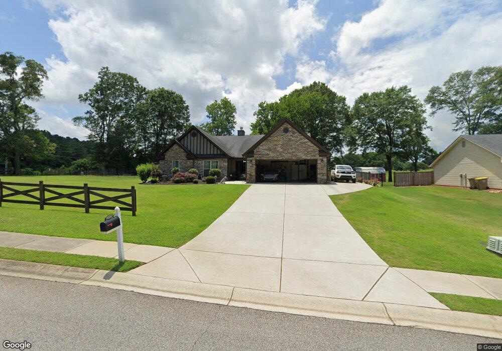
2600 Blanton Dr Unit 1 Winder, GA 30680
Estimated Value: $374,933 - $410,000
4
Beds
2
Baths
2,316
Sq Ft
$171/Sq Ft
Est. Value
About This Home
This home is located at 2600 Blanton Dr Unit 1, Winder, GA 30680 and is currently estimated at $395,233, approximately $170 per square foot. 2600 Blanton Dr Unit 1 is a home located in Barrow County with nearby schools including Statham Elementary School, Bear Creek Middle School, and Winder-Barrow High School.
Ownership History
Date
Name
Owned For
Owner Type
Purchase Details
Closed on
Apr 23, 2018
Sold by
Chappell Norma J
Bought by
Chappell Norma J and Chappell Brandi N
Current Estimated Value
Purchase Details
Closed on
Sep 26, 2014
Sold by
Southfork Homes Llc
Bought by
Chappell Paul A and Chappell Norma J
Purchase Details
Closed on
Apr 25, 2014
Sold by
Sugarloaf East Llc
Bought by
Southfork Homes
Purchase Details
Closed on
Dec 22, 2010
Sold by
State And Bank Trust Co
Bought by
Sugarloaf East Llc
Purchase Details
Closed on
Dec 1, 2009
Sold by
Lcs Llc
Bought by
Sb & T
Purchase Details
Closed on
Aug 2, 2006
Sold by
Reece Deborah P
Bought by
Lcs Llc
Create a Home Valuation Report for This Property
The Home Valuation Report is an in-depth analysis detailing your home's value as well as a comparison with similar homes in the area
Home Values in the Area
Average Home Value in this Area
Purchase History
| Date | Buyer | Sale Price | Title Company |
|---|---|---|---|
| Chappell Norma J | -- | -- | |
| Chappell Paul A | $183,800 | -- | |
| Southfork Homes | $90,000 | -- | |
| Sugarloaf East Llc | $3,700 | -- | |
| Sb & T | $1,155,000 | -- | |
| State And Bank Trust Co | -- | -- | |
| Lcs Llc | -- | -- |
Source: Public Records
Tax History Compared to Growth
Tax History
| Year | Tax Paid | Tax Assessment Tax Assessment Total Assessment is a certain percentage of the fair market value that is determined by local assessors to be the total taxable value of land and additions on the property. | Land | Improvement |
|---|---|---|---|---|
| 2024 | $3,233 | $130,949 | $19,200 | $111,749 |
| 2023 | $2,826 | $131,549 | $19,200 | $112,349 |
| 2022 | $3,133 | $110,297 | $19,200 | $91,097 |
| 2021 | $2,829 | $94,137 | $19,200 | $74,937 |
| 2020 | $2,545 | $84,473 | $16,000 | $68,473 |
| 2019 | $2,588 | $84,473 | $16,000 | $68,473 |
| 2018 | $2,365 | $78,041 | $12,800 | $65,241 |
| 2017 | $2,153 | $73,936 | $16,000 | $57,936 |
| 2016 | $2,069 | $69,347 | $16,000 | $53,347 |
| 2015 | $1,988 | $69,347 | $16,000 | $53,347 |
| 2014 | $82 | $2,600 | $2,600 | $0 |
| 2013 | -- | $2,600 | $2,600 | $0 |
Source: Public Records
Map
Nearby Homes
- 1295 Double Bridges Rd
- 1431 Solomon Dr
- 1453 Solomon Dr
- 1023 Solomon Ct
- 385 Finch Landing Rd
- 212 Rainbow Ln
- 207 Cedar Grove Church Rd
- 670 Cedar Grove Church Rd
- 113 Platte St
- 670 Cedar Grove Church Rd
- 1415 Red Oak Way
- 1724 Cedar Grove Church Rd
- 1642 White Oak Dr
- 330 Anchors Way
- 1914 Hearthstone Ct
- 1212 Highway 211 NE
- 1226 Highway 211 NE
- 51 Brockton Way Unit 2
- 315 Paige Way
- 1593 Highway 82
- 2600 Blanton Dr
- 2602 Blanton Dr Unit 2
- 2602 Blanton Dr
- 1911 Paynes Point Unit 86
- 1911 Paynes Point
- 1060 Double Bridges Rd Unit 20
- 1060 Double Bridges Rd Unit 23
- 1060 Double Bridges Rd Unit 21
- 1060 Double Bridges Rd Unit 22
- 1060 Double Bridges Rd Unit 18
- 1060 Double Bridges Rd Unit 24
- 1060 Double Bridges Rd Unit 19
- 1060 Double Bridges Rd
- 2604 Blanton Dr Unit LOT 3
- 2604 Blanton Dr Unit 3
- 2604 Blanton Dr
- 1913 Paynes Point
- 1915 Paynes Point
- 1915 Paynes Point Unit 1
- 1914 Paynes Point