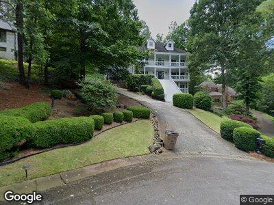
2602 Dering Gate Dr Marietta, GA 30066
Sandy Plains NeighborhoodEstimated Value: $757,000 - $861,000
4
Beds
5
Baths
4,154
Sq Ft
$193/Sq Ft
Est. Value
About This Home
This home is located at 2602 Dering Gate Dr, Marietta, GA 30066 and is currently estimated at $801,950, approximately $193 per square foot. 2602 Dering Gate Dr is a home located in Cobb County with nearby schools including Rocky Mount Elementary School, Mabry Middle School, and Lassiter High School.
Ownership History
Date
Name
Owned For
Owner Type
Purchase Details
Closed on
Sep 14, 1999
Sold by
Pelham George D
Bought by
Cartwright Billy F and Cartwright Margaret R
Current Estimated Value
Home Financials for this Owner
Home Financials are based on the most recent Mortgage that was taken out on this home.
Original Mortgage
$220,000
Interest Rate
7.91%
Mortgage Type
New Conventional
Purchase Details
Closed on
Dec 21, 1998
Sold by
Busch David E and Busch Barbara J
Bought by
Pelham George D
Home Financials for this Owner
Home Financials are based on the most recent Mortgage that was taken out on this home.
Original Mortgage
$232,000
Interest Rate
6.87%
Mortgage Type
New Conventional
Create a Home Valuation Report for This Property
The Home Valuation Report is an in-depth analysis detailing your home's value as well as a comparison with similar homes in the area
Home Values in the Area
Average Home Value in this Area
Purchase History
| Date | Buyer | Sale Price | Title Company |
|---|---|---|---|
| Cartwright Billy F | $275,000 | -- | |
| Pelham George D | $290,000 | -- |
Source: Public Records
Mortgage History
| Date | Status | Borrower | Loan Amount |
|---|---|---|---|
| Open | Cartwright Billy F | $60,000 | |
| Open | Cartwright Billy F | $181,900 | |
| Closed | Cartwright Billy F | $37,000 | |
| Closed | Cartwright Billy F | $225,000 | |
| Closed | Cartwright Billy F | $220,000 | |
| Previous Owner | Pelham George D | $232,000 |
Source: Public Records
Tax History Compared to Growth
Tax History
| Year | Tax Paid | Tax Assessment Tax Assessment Total Assessment is a certain percentage of the fair market value that is determined by local assessors to be the total taxable value of land and additions on the property. | Land | Improvement |
|---|---|---|---|---|
| 2024 | $1,568 | $249,204 | $46,000 | $203,204 |
| 2023 | $1,362 | $249,204 | $46,000 | $203,204 |
| 2022 | $1,568 | $249,204 | $46,000 | $203,204 |
| 2021 | $1,429 | $202,788 | $38,000 | $164,788 |
| 2020 | $1,375 | $184,604 | $36,400 | $148,204 |
| 2019 | $1,375 | $184,604 | $36,400 | $148,204 |
| 2018 | $1,343 | $173,772 | $36,400 | $137,372 |
| 2017 | $1,154 | $160,772 | $33,600 | $127,172 |
| 2016 | $1,161 | $160,772 | $33,600 | $127,172 |
| 2015 | $1,208 | $149,720 | $24,320 | $125,400 |
| 2014 | $1,234 | $149,720 | $0 | $0 |
Source: Public Records
Map
Nearby Homes
- 4365 Dover Crossing Dr
- 2610 Chadwick Rd
- 4358 Stockton Way
- 4314 Arbor Bridge Ct
- 4408 Brandon Ct NE
- 4546 Windsor Oaks Ct
- 4080 Glen Hill Way NE
- 4100 Devon Wood Dr NE
- 4544 Savage Dr NE
- 4103 Devon Wood Dr NE
- 4468 Windsor Oaks Dr Unit 2
- 2620 Middle Coray Cir
- 2841 Landing Dr
- 2578 Middle Coray Cir
- 4080 Longford Dr NE
- 1730 Millhouse Run
- 3920 Cash Landing
- 2602 Dering Gate Dr
- 2604 Dering Gate Dr
- 2600 Dering Gate Dr
- 2603 Ainsley Ct
- 2601 Ainsley Ct
- 2605 Dering Gate Dr
- 2607 Ainsley Ct
- 2606 Dering Gate Dr
- 2609 Ainsley Ct
- 2601 Dering Gate Dr
- 2600 Ainsley Ct
- 2607 Dering Gate Dr
- 0 Dering Gate Dr Unit 8717498
- 0 Dering Gate Dr Unit 8406769
- 0 Dering Gate Dr Unit 8227321
- 0 Dering Gate Dr Unit 8650720
- 0 Dering Gate Dr Unit 7302138
- 0 Dering Gate Dr
- 2602 Ainsley Ct
- 2608 Dering Gate Dr