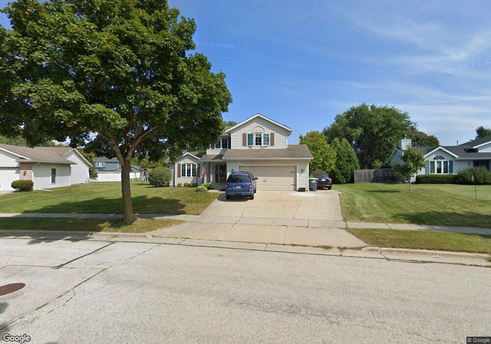
2612 Brookstone Ct Waukesha, WI 53188
Estimated Value: $429,858 - $481,000
3
Beds
3
Baths
1,530
Sq Ft
$298/Sq Ft
Est. Value
About This Home
This home is located at 2612 Brookstone Ct, Waukesha, WI 53188 and is currently estimated at $456,215, approximately $298 per square foot. 2612 Brookstone Ct is a home located in Waukesha County with nearby schools including Summit View Elementary School, Butler Middle School, and North High School.
Ownership History
Date
Name
Owned For
Owner Type
Purchase Details
Closed on
Aug 16, 2013
Sold by
Lahiff Rosin
Bought by
Lahiff Michael P
Current Estimated Value
Purchase Details
Closed on
Jun 14, 2012
Sold by
Karrels Daniel K
Bought by
Lahiff Michael and Lahiff Rosin
Home Financials for this Owner
Home Financials are based on the most recent Mortgage that was taken out on this home.
Original Mortgage
$216,000
Interest Rate
3.87%
Mortgage Type
New Conventional
Purchase Details
Closed on
Nov 23, 2009
Sold by
Karrels Daniel K and Karrels Kristine A
Bought by
Karrels Daniel K
Purchase Details
Closed on
Jul 21, 2000
Sold by
Brookstone Homes Inc
Bought by
Karrels Daniel K and Karrels Kristine A
Home Financials for this Owner
Home Financials are based on the most recent Mortgage that was taken out on this home.
Original Mortgage
$160,100
Interest Rate
7.75%
Create a Home Valuation Report for This Property
The Home Valuation Report is an in-depth analysis detailing your home's value as well as a comparison with similar homes in the area
Home Values in the Area
Average Home Value in this Area
Purchase History
| Date | Buyer | Sale Price | Title Company |
|---|---|---|---|
| Lahiff Michael P | -- | None Available | |
| Lahiff Michael | $245,000 | None Available | |
| Karrels Daniel K | -- | None Available | |
| Karrels Daniel K | $178,100 | -- |
Source: Public Records
Mortgage History
| Date | Status | Borrower | Loan Amount |
|---|---|---|---|
| Previous Owner | Lahiff Michael | $216,000 | |
| Previous Owner | Karrels Daniel K | $160,100 |
Source: Public Records
Tax History Compared to Growth
Tax History
| Year | Tax Paid | Tax Assessment Tax Assessment Total Assessment is a certain percentage of the fair market value that is determined by local assessors to be the total taxable value of land and additions on the property. | Land | Improvement |
|---|---|---|---|---|
| 2024 | $5,163 | $347,400 | $105,000 | $242,400 |
| 2023 | $5,021 | $347,400 | $105,000 | $242,400 |
| 2022 | $5,532 | $286,500 | $94,900 | $191,600 |
| 2021 | $5,669 | $286,500 | $94,900 | $191,600 |
| 2020 | $5,468 | $286,500 | $94,900 | $191,600 |
| 2019 | $5,303 | $286,500 | $94,900 | $191,600 |
| 2018 | $5,005 | $265,300 | $82,000 | $183,300 |
| 2017 | $4,985 | $265,300 | $82,000 | $183,300 |
| 2016 | $4,967 | $247,900 | $77,600 | $170,300 |
| 2015 | $4,935 | $247,900 | $77,600 | $170,300 |
| 2014 | $4,847 | $233,900 | $81,400 | $152,500 |
| 2013 | $4,847 | $233,900 | $81,400 | $152,500 |
Source: Public Records
Map
Nearby Homes
- 2605 Emslie Dr
- 2145 Broken Hill Rd Unit 5
- 2339 Bramblewood Ct
- 2732 Northview Rd Unit 88
- 2728 Northview Rd Unit 61
- The Adalyn Plan at Tallgrass - Villas
- 2112 Woodburn Rd Unit E
- 2013 Woodburn Rd Unit A
- 2127 Bluestem Dr Unit 101
- 2125 Bluestem Dr Unit 102
- 2119 Bluestem Dr Unit 201
- 2117 Bluestem Dr Unit 202
- 2106 Bluestem Dr Unit 1301
- 2108 Bluestem Dr Unit 1302
- 2912 Willard Ln
- 2312 Judith Ln
- 1825 Woodburn Rd Unit C
- 2912 N University Dr Unit 305
- 2912 N University Dr Unit 208
- 1917 Tree Line Ct
- 2608 Brookstone Ct
- 2616 Brookstone Ct
- 2611 Brookstone Ct
- 2600 Brookstone Ct
- 2604 Brookstone Ct
- 2605 Brookstone Ct
- 2601 Brookstone Ct
- 2348 Brookstone Ln
- 2356 Brookstone Ln
- 2531 Emslie Dr
- 2535 Emslie Dr
- 2541 Emslie Dr
- 2527 Emslie Dr
- 2344 Brookstone Ln
- 2523 Emslie Dr
- 2352 Brookstone Ln
- 2340 Brookstone Ln
- 2519 Emslie Dr
- 2400 Forest Hill Ct
- 2401 Forest Hill Ct