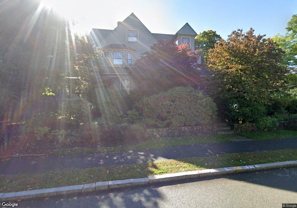
262 Otis St West Newton, MA 02465
West Newton NeighborhoodEstimated Value: $3,184,556 - $3,825,000
6
Beds
4
Baths
4,923
Sq Ft
$695/Sq Ft
Est. Value
About This Home
This home is located at 262 Otis St, West Newton, MA 02465 and is currently estimated at $3,422,889, approximately $695 per square foot. 262 Otis St is a home located in Middlesex County with nearby schools including Peirce Elementary School, F.A. Day Middle School, and Newton North High School.
Ownership History
Date
Name
Owned For
Owner Type
Purchase Details
Closed on
Nov 9, 1994
Sold by
Patrick Olive
Bought by
Roth Solomon B and Roth Donna M L
Current Estimated Value
Create a Home Valuation Report for This Property
The Home Valuation Report is an in-depth analysis detailing your home's value as well as a comparison with similar homes in the area
Home Values in the Area
Average Home Value in this Area
Purchase History
| Date | Buyer | Sale Price | Title Company |
|---|---|---|---|
| Roth Solomon B | $590,000 | -- |
Source: Public Records
Mortgage History
| Date | Status | Borrower | Loan Amount |
|---|---|---|---|
| Open | Roth Solomon B | $500,000 | |
| Closed | Roth Solomon B | $360,000 | |
| Closed | Roth Solomon B | $360,000 |
Source: Public Records
Tax History Compared to Growth
Tax History
| Year | Tax Paid | Tax Assessment Tax Assessment Total Assessment is a certain percentage of the fair market value that is determined by local assessors to be the total taxable value of land and additions on the property. | Land | Improvement |
|---|---|---|---|---|
| 2025 | $29,608 | $3,021,200 | $1,229,100 | $1,792,100 |
| 2024 | $28,628 | $2,933,200 | $1,193,300 | $1,739,900 |
| 2023 | $27,767 | $2,727,600 | $922,600 | $1,805,000 |
| 2022 | $26,569 | $2,525,600 | $854,300 | $1,671,300 |
| 2021 | $25,528 | $2,372,500 | $805,900 | $1,566,600 |
| 2020 | $24,769 | $2,372,500 | $805,900 | $1,566,600 |
| 2019 | $24,071 | $2,303,400 | $782,400 | $1,521,000 |
| 2018 | $23,671 | $2,187,700 | $710,700 | $1,477,000 |
| 2017 | $22,951 | $2,063,900 | $670,500 | $1,393,400 |
| 2016 | $21,951 | $1,928,900 | $626,600 | $1,302,300 |
| 2015 | $20,929 | $1,802,700 | $585,600 | $1,217,100 |
Source: Public Records
Map
Nearby Homes
- 318 Austin St Unit A
- 39 Valentine Park
- 123 Mount Vernon St Unit 2
- 123-125 Mount Vernon St
- 12 Wiswall St
- 4 Wiswall St
- 27 Cross St Unit 27
- 308 Prince St
- 18 Sewall St
- 40 Sewall St
- 957 Washington St Unit 1
- 935 Washington St Unit 8
- 11 Randlett Park
- 61 Lakeview Ave
- 22 Walnut Place Unit 1
- 911 Washington St
- 43 Walker St
- 10 Ruane Rd
- 321 Albemarle Rd
- 371 Cherry St