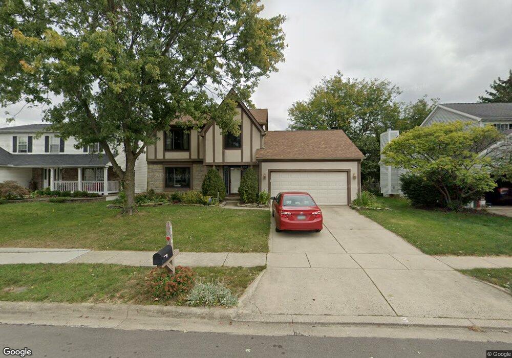
2654 Westbreeze Dr Hilliard, OH 43026
Cross Creek NeighborhoodEstimated Value: $344,599 - $417,000
3
Beds
3
Baths
1,700
Sq Ft
$225/Sq Ft
Est. Value
About This Home
This home is located at 2654 Westbreeze Dr, Hilliard, OH 43026 and is currently estimated at $382,900, approximately $225 per square foot. 2654 Westbreeze Dr is a home located in Franklin County with nearby schools including Hilliard Station Sixth Grade Elementary School, J W Reason Elementary School, and Hilliard Heritage Middle School.
Ownership History
Date
Name
Owned For
Owner Type
Purchase Details
Closed on
Sep 24, 2003
Sold by
Lowe David K and Lowe Christine M
Bought by
Grove David R
Current Estimated Value
Home Financials for this Owner
Home Financials are based on the most recent Mortgage that was taken out on this home.
Original Mortgage
$134,400
Outstanding Balance
$63,162
Interest Rate
6.43%
Mortgage Type
Purchase Money Mortgage
Estimated Equity
$319,738
Purchase Details
Closed on
Feb 12, 1990
Bought by
Lowe David K
Create a Home Valuation Report for This Property
The Home Valuation Report is an in-depth analysis detailing your home's value as well as a comparison with similar homes in the area
Home Values in the Area
Average Home Value in this Area
Purchase History
| Date | Buyer | Sale Price | Title Company |
|---|---|---|---|
| Grove David R | $168,000 | Amerititle Agency Inc | |
| Lowe David K | $109,800 | -- |
Source: Public Records
Mortgage History
| Date | Status | Borrower | Loan Amount |
|---|---|---|---|
| Open | Grove David R | $134,400 |
Source: Public Records
Tax History Compared to Growth
Tax History
| Year | Tax Paid | Tax Assessment Tax Assessment Total Assessment is a certain percentage of the fair market value that is determined by local assessors to be the total taxable value of land and additions on the property. | Land | Improvement |
|---|---|---|---|---|
| 2024 | $4,916 | $87,050 | $29,050 | $58,000 |
| 2023 | $5,543 | $113,295 | $29,050 | $84,245 |
| 2022 | $4,868 | $79,660 | $17,500 | $62,160 |
| 2021 | $4,863 | $79,660 | $17,500 | $62,160 |
| 2020 | $4,849 | $79,660 | $17,500 | $62,160 |
| 2019 | $4,416 | $61,950 | $14,000 | $47,950 |
| 2018 | $4,398 | $61,950 | $14,000 | $47,950 |
| 2017 | $4,398 | $61,950 | $14,000 | $47,950 |
| 2016 | $4,692 | $61,220 | $13,270 | $47,950 |
| 2015 | $4,398 | $61,220 | $13,270 | $47,950 |
| 2014 | $4,406 | $61,220 | $13,270 | $47,950 |
| 2013 | $2,301 | $63,105 | $12,635 | $50,470 |
Source: Public Records
Map
Nearby Homes
- 5215 Bressler Dr
- 5188 Calhoon Ct
- 5112 Bressler Dr
- 5258 Skytrail Dr
- 5052 Bressler Dr
- 2477 Crystal Springs Dr
- 2759 Lyndley Ct
- 2657 Village Pier Ln Unit 2657
- 2756 Shelton Cir
- 5285 Redlands Dr
- 4995 Singleton Dr
- 4995 Singleton Dr Unit 18c
- 4976 Shady Oak Dr
- 5459 Red Wynne Ln
- 2967 Castlebrook Ave
- 4945 Singleton Dr Unit 13C
- 3003 Parker Ln
- 5488 Whispering Oak Blvd
- 5341 Hyde Park Dr
- 2880 Wynneleaf St
- 2662 Westbreeze Dr
- 2646 Westbreeze Dr
- 2670 Westbreeze Dr
- 5244 Carifa Ct
- 5239 Carifa Ct
- 2638 Westbreeze Dr
- 2659 Westbreeze Dr
- 5279 Whirlwind Cove Dr
- 2678 Westbreeze Dr
- 5238 Carifa Ct
- 5233 Carifa Ct
- 2665 Westbreeze Dr
- 2630 Westbreeze Dr
- 5244 Bressler Dr
- 5287 Whirlwind Cove Dr
- 5236 Bressler Dr
- 2671 Westbreeze Dr
- 5257 Westbridge Rd
- 5249 Westbridge Rd
- 5227 Carifa Ct