Estimated Value: $7,811,000 - $9,461,807
3
Beds
5
Baths
3,487
Sq Ft
$2,480/Sq Ft
Est. Value
About This Home
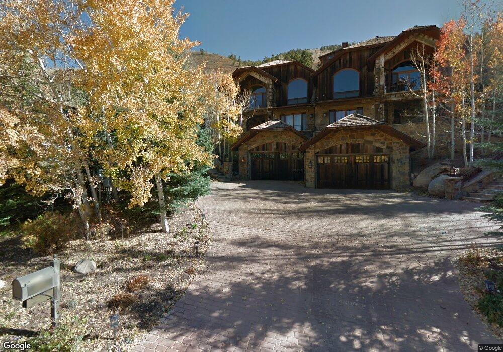
This home is located at 268 Mountain Laurel Dr Unit A, Aspen, CO 81611 and is currently estimated at $8,646,202, approximately $2,479 per square foot. 268 Mountain Laurel Dr Unit A is a home located in Pitkin County with nearby schools including Aspen Elementary School, Aspen Middle School, and Aspen High School.
Ownership History
Date
Name
Owned For
Owner Type
Purchase Details
Closed on
Jan 12, 2021
Sold by
Neill Marie D O
Bought by
Keefe Marie D O Neill and Keefe Michael K
Current Estimated Value
Purchase Details
Closed on
Apr 22, 2011
Sold by
Mazzeo Michael
Bought by
Oneill Marie D
Purchase Details
Closed on
May 10, 2005
Sold by
Robinson Thomas E and Robinson Patricia
Bought by
Mazzeo Michael
Home Financials for this Owner
Home Financials are based on the most recent Mortgage that was taken out on this home.
Original Mortgage
$2,000,000
Interest Rate
5.87%
Mortgage Type
Fannie Mae Freddie Mac
Purchase Details
Closed on
May 13, 2004
Sold by
Davidson Ariail Scott
Bought by
Robinson Thomas E and Robinson Patricia
Home Financials for this Owner
Home Financials are based on the most recent Mortgage that was taken out on this home.
Original Mortgage
$2,177,500
Interest Rate
5.53%
Mortgage Type
Purchase Money Mortgage
Create a Home Valuation Report for This Property
The Home Valuation Report is an in-depth analysis detailing your home's value as well as a comparison with similar homes in the area
Home Values in the Area
Average Home Value in this Area
Purchase History
| Date | Buyer | Sale Price | Title Company |
|---|---|---|---|
| Keefe Marie D O Neill | -- | None Available | |
| Oneill Marie D | $2,500,000 | None Available | |
| Mazzeo Michael | $3,825,000 | Land Title | |
| Robinson Thomas E | $3,350,000 | -- |
Source: Public Records
Mortgage History
| Date | Status | Borrower | Loan Amount |
|---|---|---|---|
| Previous Owner | Mazzeo Michael | $2,000,000 | |
| Previous Owner | Robinson Thomas E | $2,177,500 |
Source: Public Records
Tax History Compared to Growth
Tax History
| Year | Tax Paid | Tax Assessment Tax Assessment Total Assessment is a certain percentage of the fair market value that is determined by local assessors to be the total taxable value of land and additions on the property. | Land | Improvement |
|---|---|---|---|---|
| 2024 | $15,994 | $550,730 | $0 | $550,730 |
| 2023 | $15,994 | $558,780 | $0 | $558,780 |
| 2022 | $10,336 | $322,800 | $0 | $322,800 |
| 2021 | $10,310 | $332,090 | $0 | $332,090 |
| 2020 | $9,456 | $303,670 | $0 | $303,670 |
| 2019 | $9,456 | $303,670 | $0 | $303,670 |
| 2018 | $8,353 | $305,790 | $0 | $305,790 |
| 2017 | $7,262 | $267,980 | $0 | $267,980 |
| 2016 | $7,144 | $258,520 | $0 | $258,520 |
| 2015 | $7,101 | $258,520 | $0 | $258,520 |
| 2014 | $5,819 | $206,810 | $0 | $206,810 |
Source: Public Records
Map
Nearby Homes
- 184 Mountain Laurel Dr
- 602 Mountain Laurel Dr
- 552 Mountain Laurel Dr
- 161 Stillwater Ln
- 1271 S Ute Ave
- 71 & 73 Smuggler Grove Rd
- 1212 E Hopkins Ave
- 326 Midland Ave Unit 306
- 326 Midland Ave Unit 302
- 322 Park Ave Unit 2
- 1034 E Cooper Ave Unit 19A
- 10 Ute Place
- 1024 E Hopkins Ave Unit 16
- 939 E Cooper Ave Unit B
- 940 Waters Ave Unit 201
- 415 Park Cir Unit 5
- 425 Park Cir Unit A2
- 515 Park Cir
- 610 S West End St Unit D304
- 610 S West End St Unit D 206
- 260 Mountain Laurel Dr Unit B
- 284 Mountain Laurel Dr
- 250 Mountain Laurel Dr Unit B
- 250 Mountain Laurel Dr Unit A
- 250 Mountain Laurel Dr Unit B
- 250 Mountain Laurel Dr
- 250 Mountain Laurel Dr Unit A
- 780 Mountain Laurel Dr
- 756 Mountain Laurel Dr
- 314 Mountain Laurel Dr
- 281 Mountain Laurel Dr
- 242 Mountain Laurel Dr
- 309 Mountain Laurel Dr
- 798 Mountain Laurel Dr
- 257 Mountain Laurel Dr
- 76 Mountain Laurel Ln
- 76 Mountain Laurel Ln
- 348 Mountain Laurel Dr
- 107 W Lupine Dr
- 234 Mountain Laurel Dr