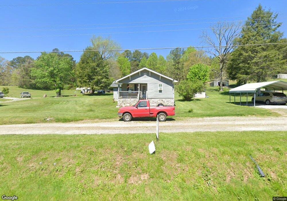
2683 Highway 68 Turtletown, TN 37391
Estimated Value: $117,497 - $211,000
--
Bed
1
Bath
1,188
Sq Ft
$125/Sq Ft
Est. Value
About This Home
This home is located at 2683 Highway 68, Turtletown, TN 37391 and is currently estimated at $148,374, approximately $124 per square foot. 2683 Highway 68 is a home located in Polk County.
Ownership History
Date
Name
Owned For
Owner Type
Purchase Details
Closed on
Jun 16, 1999
Sold by
Key Fred M
Bought by
Timmy Hemming
Current Estimated Value
Purchase Details
Closed on
Jun 23, 1997
Purchase Details
Closed on
Aug 31, 1993
Bought by
Centers Shirley Loudermilk
Purchase Details
Closed on
Jul 7, 1990
Bought by
Adams Freda
Purchase Details
Closed on
Aug 15, 1978
Bought by
Smith Ronnie G and Smith Tammy
Create a Home Valuation Report for This Property
The Home Valuation Report is an in-depth analysis detailing your home's value as well as a comparison with similar homes in the area
Home Values in the Area
Average Home Value in this Area
Purchase History
| Date | Buyer | Sale Price | Title Company |
|---|---|---|---|
| Timmy Hemming | $30,000 | -- | |
| -- | $10,000 | -- | |
| Centers Shirley Loudermilk | $14,300 | -- | |
| Adams Freda | $24,000 | -- | |
| Smith Ronnie G | -- | -- |
Source: Public Records
Tax History Compared to Growth
Tax History
| Year | Tax Paid | Tax Assessment Tax Assessment Total Assessment is a certain percentage of the fair market value that is determined by local assessors to be the total taxable value of land and additions on the property. | Land | Improvement |
|---|---|---|---|---|
| 2025 | $419 | $24,775 | $3,350 | $21,425 |
| 2024 | $419 | $24,775 | $3,350 | $21,425 |
| 2023 | $419 | $24,775 | $0 | $0 |
| 2022 | $368 | $14,650 | $3,200 | $11,450 |
| 2021 | $368 | $14,650 | $3,200 | $11,450 |
| 2020 | $368 | $14,650 | $3,200 | $11,450 |
| 2019 | $368 | $14,650 | $3,200 | $11,450 |
| 2018 | $368 | $14,650 | $3,200 | $11,450 |
| 2017 | $378 | $14,975 | $3,200 | $11,775 |
| 2016 | $360 | $14,975 | $3,200 | $11,775 |
| 2015 | $360 | $14,975 | $3,200 | $11,775 |
| 2014 | $360 | $14,984 | $0 | $0 |
Source: Public Records
Map
Nearby Homes
- 123 Ridgeline Dr
- 240 McJunkin Rd
- LOT32 Lakeview Dr
- 00 Laurel Dr
- 2352 Tennessee 68
- 198 Laurel Dr
- 360 Johnson Cove Rd
- 367 Beaver Cove Rd
- 00 Stiles Rd
- 130 Golden Eagle Cir
- 114 Blackhawk Ln
- 115 Blackhawk
- 626 Brush Creek Rd
- 1868 Tennessee 68
- 0 Little Mountain Rd Unit 1512316
- 00 Little Mountain Rd
- 0 Singo Dr
- 119 Cantrell Ln
- 113 Spruce St
- 113 Hideaway Trail
- 2669 Highway 68
- 2699 Highway 68
- 2684 Highway 68
- 2670 Highway 68
- 2709 Highway 68
- 2708 Hwy 68n
- 2708 Tennessee 68
- 2708 Highway 68
- 2660 Highway 68
- 2660 Tennessee 68
- 2645 Highway 68
- 2731 Highway 68
- 2599 Tennessee 68
- 2599 Highway 68
- 2602 Tennessee 68
- 2746 Tennessee 68
- 140 Hyatt Bigham Rd
- 0 Hyatt Bigham Rd Unit 274238
- 2714 Highway 68
- LOT25 Rocky Branch Dr