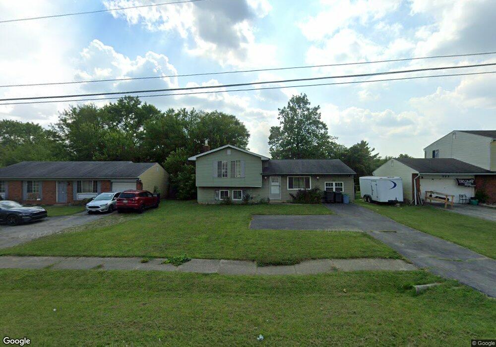
269 Hubbard Rd Galloway, OH 43119
Estimated Value: $244,000 - $269,000
3
Beds
2
Baths
1,142
Sq Ft
$223/Sq Ft
Est. Value
About This Home
This home is located at 269 Hubbard Rd, Galloway, OH 43119 and is currently estimated at $254,915, approximately $223 per square foot. 269 Hubbard Rd is a home located in Franklin County with nearby schools including Galloway Ridge Intermediate School, Alton Hall Elementary School, and Norton Middle School.
Ownership History
Date
Name
Owned For
Owner Type
Purchase Details
Closed on
Nov 22, 2016
Sold by
Harrison Earl E
Bought by
Harrison Earl E and The Federation Trust
Current Estimated Value
Purchase Details
Closed on
Oct 9, 1987
Bought by
Harrison Earl E
Purchase Details
Closed on
Aug 21, 1987
Purchase Details
Closed on
Dec 1, 1983
Create a Home Valuation Report for This Property
The Home Valuation Report is an in-depth analysis detailing your home's value as well as a comparison with similar homes in the area
Home Values in the Area
Average Home Value in this Area
Purchase History
| Date | Buyer | Sale Price | Title Company |
|---|---|---|---|
| Harrison Earl E | -- | None Available | |
| Harrison Earl E | $51,000 | -- | |
| -- | $47,500 | -- | |
| -- | -- | -- |
Source: Public Records
Tax History
| Year | Tax Paid | Tax Assessment Tax Assessment Total Assessment is a certain percentage of the fair market value that is determined by local assessors to be the total taxable value of land and additions on the property. | Land | Improvement |
|---|---|---|---|---|
| 2025 | $3,097 | $68,850 | $20,790 | $48,060 |
| 2024 | $3,097 | $68,850 | $20,790 | $48,060 |
| 2023 | $2,956 | $68,845 | $20,790 | $48,055 |
| 2022 | $2,773 | $45,370 | $9,560 | $35,810 |
| 2021 | $2,817 | $45,370 | $9,560 | $35,810 |
| 2020 | $2,805 | $45,370 | $9,560 | $35,810 |
| 2019 | $2,718 | $38,400 | $7,980 | $30,420 |
| 2018 | $2,512 | $38,400 | $7,980 | $30,420 |
| 2017 | $2,562 | $38,400 | $7,980 | $30,420 |
| 2016 | $2,314 | $31,680 | $5,850 | $25,830 |
| 2015 | $2,314 | $31,680 | $5,850 | $25,830 |
| 2014 | $2,316 | $31,680 | $5,850 | $25,830 |
| 2013 | $1,273 | $35,175 | $6,475 | $28,700 |
Source: Public Records
Map
Nearby Homes
- 375 Darby Ct
- 716 Academy Dr
- 8652 Westpoint Dr
- 8458 Squad Dr
- 8873 Canoe Dr
- 914 Slagle Place
- 0 Dellinger Rd Unit 9 2030113
- 1276 Four Star Dr E
- 430 Trillium Dr
- 116 S Frey Ave
- 145 Center Ave Unit 149
- 41 N Hampton St
- 728 Murnan Rd
- 263 Merriman Dr
- 306 Madison Dr S
- 36 Putnam Ave
- 484 London Rd
- 6515 W Broad St
- 670 Hillsdale Dr
- 6489 W Broad St
- 277 Hubbard Rd
- 261 Hubbard Rd
- 253 Hubbard Rd
- 8557 Canyon Cove Rd
- 285 Hubbard Rd
- 8565 Canyon Cove Rd
- 8549 Canyon Cove Rd
- 8573 Canyon Cove Rd
- 8567 Renaa Ave
- 268 Hubbard Rd
- 260 Hubbard Rd
- 284 Hubbard Rd
- 8534 Conbrook Ct
- 8581 Canyon Cove Rd
- 237 Hubbard Rd
- 292 Hubbard Rd
- 307 Hubbard Rd
- 8560 Renaa Ave
- 8578 Canyon Cove Rd
- 8556 Canyon Cove Rd
Your Personal Tour Guide
Ask me questions while you tour the home.