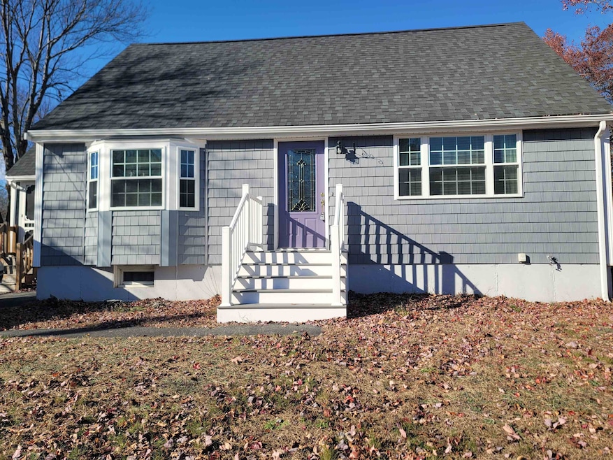
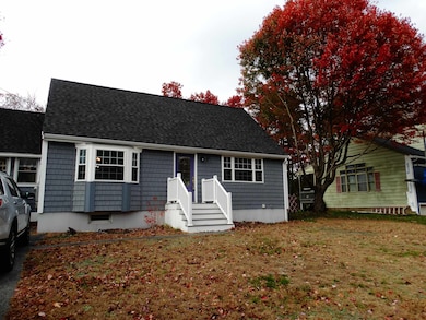
27 General Pulaski Dr Salem, NH 03079
Salem Center NeighborhoodEstimated payment $3,617/month
Highlights
- Cape Cod Architecture
- Dining Room
- Level Lot
- Fireplace
About This Home
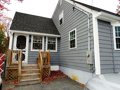
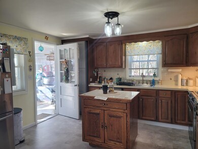
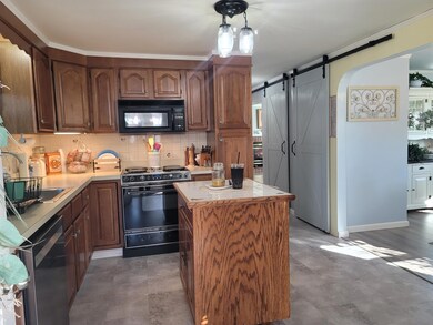
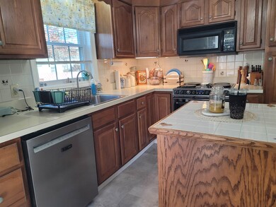
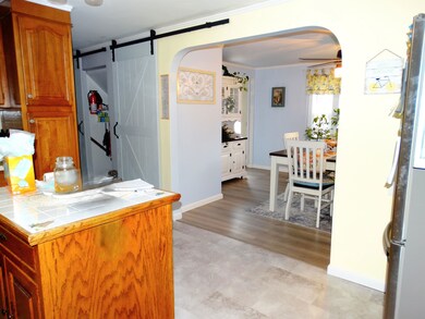
MOTIVATED SELLER! This lovely Cape is centrally located and Nestled in a neighborhood with easy highway access, close to schools, shopping and all the amenities of Tuscan Village. When entering the front door you will find a large front to back living room with new flooring, gas fireplace for those cool nights and new Harvey windows thru out. Dining room with newer flooring and great open floor plan to the Kitchen. The kitchen offers great cabinet space, center island and access to the enclosed 3 season porch. The 3 season porch is so inviting and has access to the fully fenced in back yard. Full bathroom complete the first floor. Upstairs you will find 3 bedrooms and a half bathroom. Large fenced in yard with storage shed, wood patio area and lots of room to run and still has electric wiring and box for anyone wanting a pool. Recent updates including roof, windows & siding. All appliances to remain with the property. Includes LL square footage. OPEN HOUSE SAT NOV 15TH 12:00-2:00
Subject to Seller finding suitable housing.
Listing Agent
BHHS Verani Windham Brokerage Phone: 978-314-0822 License #059649 Listed on: 11/03/2025

Home Details
Home Type
- Single Family
Est. Annual Taxes
- $7,049
Year Built
- Built in 1968
Lot Details
- 0.37 Acre Lot
- Level Lot
Home Design
- Cape Cod Architecture
- Concrete Foundation
- Wood Frame Construction
- Vinyl Siding
Interior Spaces
- Property has 2 Levels
- Fireplace
- Dining Room
- Finished Basement
- Interior Basement Entry
Kitchen
- Microwave
- Dishwasher
Bedrooms and Bathrooms
- 3 Bedrooms
Laundry
- Dryer
- Washer
Parking
- Paved Parking
- Off-Street Parking
Schools
- Woodbury Middle School
- Salem High School
Utilities
- Window Unit Cooling System
- Phone Available
- Cable TV Available
Listing and Financial Details
- Legal Lot and Block 27 / 6931
- Assessor Parcel Number 67
Map
Home Values in the Area
Average Home Value in this Area
Tax History
| Year | Tax Paid | Tax Assessment Tax Assessment Total Assessment is a certain percentage of the fair market value that is determined by local assessors to be the total taxable value of land and additions on the property. | Land | Improvement |
|---|---|---|---|---|
| 2024 | $7,049 | $400,500 | $161,600 | $238,900 |
| 2023 | $6,792 | $400,500 | $161,600 | $238,900 |
| 2022 | $6,428 | $400,500 | $161,600 | $238,900 |
| 2021 | $6,400 | $400,500 | $161,600 | $238,900 |
| 2020 | $5,871 | $266,600 | $115,400 | $151,200 |
| 2019 | $5,860 | $266,600 | $115,400 | $151,200 |
| 2018 | $5,761 | $266,600 | $115,400 | $151,200 |
| 2017 | $5,556 | $266,600 | $115,400 | $151,200 |
| 2016 | $5,447 | $266,600 | $115,400 | $151,200 |
| 2015 | $4,995 | $233,500 | $118,200 | $115,300 |
| 2014 | $4,854 | $233,500 | $118,200 | $115,300 |
| 2013 | $4,777 | $233,500 | $118,200 | $115,300 |
Property History
| Date | Event | Price | List to Sale | Price per Sq Ft |
|---|---|---|---|---|
| 11/09/2025 11/09/25 | Price Changed | $575,000 | -0.9% | $310 / Sq Ft |
| 11/03/2025 11/03/25 | For Sale | $580,000 | -- | $313 / Sq Ft |
Purchase History
| Date | Type | Sale Price | Title Company |
|---|---|---|---|
| Warranty Deed | $135,000 | -- |
Mortgage History
| Date | Status | Loan Amount | Loan Type |
|---|---|---|---|
| Open | $100,000 | Unknown | |
| Closed | $121,500 | Purchase Money Mortgage |
Source: PrimeMLS
MLS Number: 5068370
APN: SLEM-000067-006931
Disclaimer: Certain information contained herein is derived from information provided by parties other than Homes.com. All information provided is deemed reliable, but is not guaranteed to be accurate and should be independently verified.
![]() Copyright 2025 PrimeMLS, Inc. All rights reserved. This information is deemed reliable, but not guaranteed. The data relating to real estate displayed on this display comes in part from the IDX Program of PrimeMLS. The information being provided is for consumers’ personal, non-commercial use and may not be used for any purpose other than to identify prospective properties consumers may be interested in purchasing.
Copyright 2025 PrimeMLS, Inc. All rights reserved. This information is deemed reliable, but not guaranteed. The data relating to real estate displayed on this display comes in part from the IDX Program of PrimeMLS. The information being provided is for consumers’ personal, non-commercial use and may not be used for any purpose other than to identify prospective properties consumers may be interested in purchasing.
- 10 Townsend Ave
- 81 N Main St
- 51 Bluff St
- 55A Millville Cir
- 2 Millville Terrace
- 18 Hawkins Pond Ln
- 18 Field Ave
- 6 Douglas Dr
- 8 Arcadia Ln
- 1 Ballard Ln
- 1 Cottonwood Ln
- 4 Therriault Ave
- 3 Roux Ave
- 11 Marsh Ave
- 20 Stanwood Rd
- 30 Scotland Ave
- 8 Stoneybrook Ln
- 40 Stanwood Rd Unit 9
- 312 Shore Dr
- 51 Zion Hill Rd
- 31 Bridge St
- 205 N Main St
- 4f Therese Rd Unit 4F Therese Rd Salem NH
- 14 Clare Ln
- 41-45 Main St
- 332-334 N N
- 21 Orchard Terrace Unit 2
- 22 Via Toscana
- 10 Braemoor Woods Rd Unit 404
- 4 Tuscan Blvd
- 15 Artisan Dr
- 18 Artisan Dr Unit 205
- 18 Artisan Dr Unit 219
- 18 Artisan Dr Unit 402
- 10 Tiffany Rd Unit 6
- 103 Cluff Crossing Rd
- 15 Shore Dr
- 3 S Shore Rd Unit 3
- 113 Cluff Crossing Rd Unit 11
- 67 Rockingham Rd Unit A-1