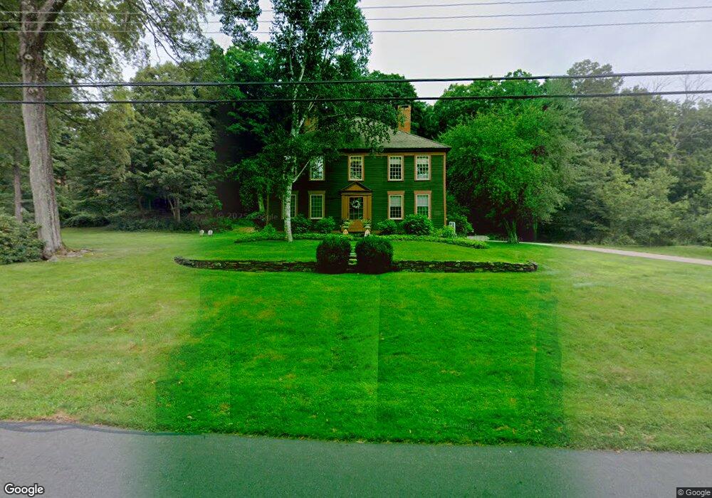
27 Hoskins Rd Bloomfield, CT 06002
Estimated Value: $555,000 - $633,000
4
Beds
3
Baths
3,245
Sq Ft
$182/Sq Ft
Est. Value
About This Home
This home is located at 27 Hoskins Rd, Bloomfield, CT 06002 and is currently estimated at $591,298, approximately $182 per square foot. 27 Hoskins Rd is a home located in Hartford County with nearby schools including Laurel School, Metacomet School, and Carmen Arace Intermediate School.
Ownership History
Date
Name
Owned For
Owner Type
Purchase Details
Closed on
Aug 31, 2005
Sold by
Thomas Richard and Bladwin Elissa
Bought by
Bowie Douglas and Bowie Coreinne
Current Estimated Value
Purchase Details
Closed on
Jul 11, 2003
Sold by
Cook Landis and Cook Kristen
Bought by
Baldwin Elissa and Thomas Richard
Purchase Details
Closed on
Nov 23, 1998
Sold by
Grandahl Robert and Grandahl Catherine
Bought by
Cook Landis and Cook Kirsten
Create a Home Valuation Report for This Property
The Home Valuation Report is an in-depth analysis detailing your home's value as well as a comparison with similar homes in the area
Home Values in the Area
Average Home Value in this Area
Purchase History
| Date | Buyer | Sale Price | Title Company |
|---|---|---|---|
| Bowie Douglas | $380,000 | -- | |
| Bowie Douglas | $380,000 | -- | |
| Baldwin Elissa | $338,000 | -- | |
| Baldwin Elissa | $338,000 | -- | |
| Cook Landis | $220,000 | -- | |
| Cook Landis | $220,000 | -- |
Source: Public Records
Mortgage History
| Date | Status | Borrower | Loan Amount |
|---|---|---|---|
| Open | Cook Landis | $102,300 | |
| Open | Cook Landis | $211,000 |
Source: Public Records
Tax History Compared to Growth
Tax History
| Year | Tax Paid | Tax Assessment Tax Assessment Total Assessment is a certain percentage of the fair market value that is determined by local assessors to be the total taxable value of land and additions on the property. | Land | Improvement |
|---|---|---|---|---|
| 2025 | $11,918 | $317,800 | $64,680 | $253,120 |
| 2024 | $7,694 | $196,070 | $48,930 | $147,140 |
| 2023 | $7,555 | $196,070 | $48,930 | $147,140 |
| 2022 | $7,064 | $196,070 | $48,930 | $147,140 |
| 2021 | $7,221 | $196,070 | $48,930 | $147,140 |
| 2020 | $7,109 | $196,070 | $48,930 | $147,140 |
| 2019 | $7,537 | $194,950 | $48,930 | $146,020 |
| 2018 | $7,445 | $192,780 | $48,930 | $143,850 |
| 2017 | $7,434 | $192,780 | $48,930 | $143,850 |
| 2016 | $7,258 | $192,780 | $48,930 | $143,850 |
| 2015 | $7,123 | $192,780 | $48,930 | $143,850 |
| 2014 | $8,569 | $239,750 | $60,340 | $179,410 |
Source: Public Records
Map
Nearby Homes
- 68 Tariffville Rd
- 9 Tunxis Place
- 23 Maple St
- 158 Tariffville Rd
- 5 Tunxis Place Unit C
- 24 Hunting Ridge Dr
- 19 Simsbury Landing
- 7 Peppercorn Ln
- 67 Adams Rd
- 11 Mallard Cir
- 14 Teal Cir Unit 14
- 2 Quail Dr Unit 2
- 4 Sage Ln
- 11 Boysen Dr
- 14 Main Street Extension
- 394 Tunxis Ave
- 87 Cambridge Ct
- 45 Hoskins Rd
- 15 Pinnacle Mountain Rd
- 26 Winterset Ln