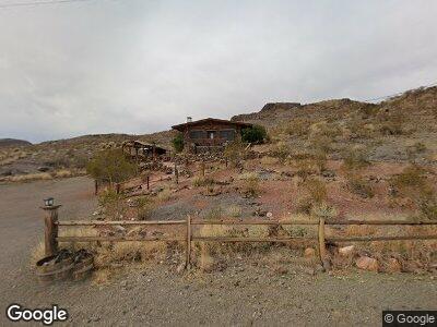
27 S Oatman Hwy Oatman, AZ 86433
Estimated Value: $107,186 - $426,000
1
Bed
1
Bath
864
Sq Ft
$241/Sq Ft
Est. Value
About This Home
This home is located at 27 S Oatman Hwy, Oatman, AZ 86433 and is currently estimated at $207,797, approximately $240 per square foot. 27 S Oatman Hwy is a home located in Mohave County with nearby schools including Fort Mohave Elementary School, Camp Mohave Elementary School, and Mohave Valley Junior High School.
Ownership History
Date
Name
Owned For
Owner Type
Purchase Details
Closed on
Nov 22, 2017
Sold by
Mccarthy Thomas
Bought by
Kent Cliffton and Kent Karen
Current Estimated Value
Purchase Details
Closed on
Oct 17, 2017
Sold by
Mccarthy Thomas and Mccarthy Tom
Bought by
Dille Stacy and Dille Stacy Kristen
Purchase Details
Closed on
Aug 11, 2017
Sold by
Mccarthy Thomas and Mccarthy Tom
Bought by
Dille Stacy and Dille Stacy Kristen
Purchase Details
Closed on
Jan 7, 2015
Sold by
Mccarthy Rom and Mccarthy Thomas Matthew
Bought by
Dille Stacy Kristen
Purchase Details
Closed on
Dec 21, 2012
Sold by
Grunige Jason
Bought by
Mccarthy Tom
Purchase Details
Closed on
Jul 16, 2012
Sold by
Grunigen Jason
Bought by
Mccarthy Tom
Purchase Details
Closed on
Jun 30, 2010
Sold by
Grunigen Jere C
Bought by
Grunigen Jason
Purchase Details
Closed on
Jul 16, 2007
Sold by
Loerch Eric A
Bought by
Grunigen Jore C
Create a Home Valuation Report for This Property
The Home Valuation Report is an in-depth analysis detailing your home's value as well as a comparison with similar homes in the area
Home Values in the Area
Average Home Value in this Area
Purchase History
| Date | Buyer | Sale Price | Title Company |
|---|---|---|---|
| Kent Cliffton | -- | Accommodation | |
| Dille Stacy | -- | None Available | |
| Dille Stacy | $17,745 | None Available | |
| Dille Stacy Kristen | $18,040 | None Available | |
| Mccarthy Tom | -- | Pioneer Title Agency Inc | |
| Mccarthy Tom | -- | None Available | |
| Mccarthy Tom | -- | None Available | |
| Grunigen Jason | -- | None Available | |
| Grunigen Jore C | $100,000 | First American Title Ins Co |
Source: Public Records
Mortgage History
| Date | Status | Borrower | Loan Amount |
|---|---|---|---|
| Previous Owner | Mccarthy Tom | $74,750 |
Source: Public Records
Tax History Compared to Growth
Tax History
| Year | Tax Paid | Tax Assessment Tax Assessment Total Assessment is a certain percentage of the fair market value that is determined by local assessors to be the total taxable value of land and additions on the property. | Land | Improvement |
|---|---|---|---|---|
| 2025 | $526 | $7,487 | $0 | $0 |
| 2024 | $526 | $8,850 | $0 | $0 |
| 2023 | $526 | $6,397 | $0 | $0 |
| 2022 | $526 | $5,669 | $0 | $0 |
| 2021 | $536 | $4,946 | $0 | $0 |
| 2019 | $500 | $4,281 | $0 | $0 |
| 2018 | $462 | $3,548 | $0 | $0 |
| 2017 | $467 | $3,518 | $0 | $0 |
| 2016 | $414 | $3,284 | $0 | $0 |
| 2015 | $560 | $4,235 | $0 | $0 |
Source: Public Records
Map
Nearby Homes
- 00 S Oatman Hwy
- 000 Na
- 018 San Francisco Mining District
- Lot 7 Carter St
- Lot 6 Carter St
- Lot 8 Carter St
- 008 San Francisco Mining District
- 6351 S 7570 St E
- na Hwy 66
- 9001 W Oatman Hwy
- 1 Silver Creek Rd
- - W Oatman Highway -- Unit 2
- - W Oatman Highway --
- 12661 Oatman Hwy
- 12651 Oatman Hwy
- 640 Acres Oatman Hwy
- Lot 1227 Oatman Hwy
- 0 Oatman Hwy
- 156 Oatman Hwy
- 20919104 W Geronimo Dr
- na S Oatman Hwy Route 66
- TBD Off Oatman
- 0000 Oatman Rd
- unk Oatman
- 27 S Oatman Hwy
- 20 Acres Oatman Hwy
- 0000 Oatman Highway --
- 84 Quail Dr
- 84 Quail
- 66 Oatman Hwy
- 9 Oatman Hwy
- 89 Main St
- 84 Quail Dr
- 121 Oatman Hwy
- 121 Main St
- 125/159 W Oatman Hwy Bali Hi Dr
- 23 Oatman Rd
- 160 Historic Route 66
- 160 Route 66
- 81 Bell Ln