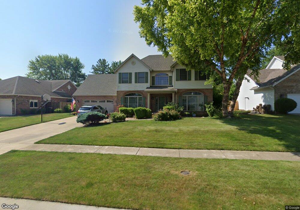
2704 Hazelnut Dr Springfield, IL 62702
Estimated Value: $303,000 - $407,000
Studio
--
Bath
--
Sq Ft
11,761
Sq Ft Lot
About This Home
This home is located at 2704 Hazelnut Dr, Springfield, IL 62702 and is currently estimated at $362,444. 2704 Hazelnut Dr is a home located in Sangamon County with nearby schools including Dubois Elementary School, U.S. Grant Middle School, and Springfield High School.
Ownership History
Date
Name
Owned For
Owner Type
Purchase Details
Closed on
Sep 12, 1994
Current Estimated Value
Create a Home Valuation Report for This Property
The Home Valuation Report is an in-depth analysis detailing your home's value as well as a comparison with similar homes in the area
Purchase History
| Date | Buyer | Sale Price | Title Company |
|---|---|---|---|
| -- | $191,000 | -- |
Source: Public Records
Tax History
| Year | Tax Paid | Tax Assessment Tax Assessment Total Assessment is a certain percentage of the fair market value that is determined by local assessors to be the total taxable value of land and additions on the property. | Land | Improvement |
|---|---|---|---|---|
| 2024 | $8,727 | $114,904 | $21,351 | $93,553 |
| 2023 | $8,307 | $104,954 | $19,502 | $85,452 |
| 2022 | $7,883 | $98,976 | $18,500 | $80,476 |
| 2021 | $7,585 | $95,270 | $17,807 | $77,463 |
| 2020 | $7,436 | $95,413 | $17,834 | $77,579 |
| 2019 | $7,294 | $95,080 | $17,772 | $77,308 |
| 2018 | $7,065 | $94,616 | $17,685 | $76,931 |
| 2017 | $6,907 | $93,392 | $17,456 | $75,936 |
| 2016 | $7,175 | $92,030 | $17,201 | $74,829 |
| 2015 | $7,099 | $90,929 | $16,995 | $73,934 |
| 2014 | $6,854 | $90,342 | $16,885 | $73,457 |
| 2013 | $6,701 | $88,704 | $16,885 | $71,819 |
Source: Public Records
Map
Nearby Homes
- 6 Redwood Ln
- 812 Roanoke Dr
- 160 S Durkin Dr Unit 4
- 36 Trailridge Ln Unit 152
- 243 S Durkin Dr Unit 24
- 804 Fairfax Ct
- 107 Collier Dr
- 1038 N Koke Mill Rd
- 3400 Briana Dr
- 2651 W Lawrence Ave Unit 2
- 504 Brandywine Rd
- 3229 W Point Dr
- 2900 W Lawrence Ave
- 3424 Bluff Rd
- 2510 & 2518 W Jefferson St
- 3613 Briana Dr
- 3612 Melissa Dr
- 1913 Jeanette Ln Unit 8
- 1914 Jeanette Ln Unit 6
- 2309 W Lawrence Ave
- 2708 Hazelnut Dr
- 2700 Hazelnut Dr
- 97 Mccarthy Dr
- 93 Mccarthy Dr
- 89 Mccarthy Dr
- 100 Mccarthy Dr
- 2712 Hazelnut Dr
- 404 Silver Spring Dr
- 401 N Durkin Dr
- 104 Mccarthy Dr
- 2624 Hazelnut Dr
- 401 Silver Spring Dr
- 405 Silver Spring Dr
- 85 Mccarthy Dr
- 408 Silver Spring Dr
- 405 N Durkin Dr
- 232 Bristol Dr
- 241 Bristol Dr
- 81 Mccarthy Dr
- 2621 Hazelnut Dr
Your Personal Tour Guide
Ask me questions while you tour the home.