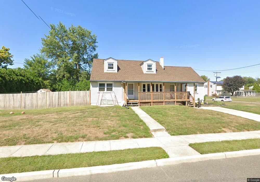
271 Middlesex Ave Thorofare, NJ 08086
Estimated Value: $346,802 - $440,000
Studio
--
Bath
2,228
Sq Ft
$183/Sq Ft
Est. Value
About This Home
This home is located at 271 Middlesex Ave, Thorofare, NJ 08086 and is currently estimated at $407,701, approximately $182 per square foot. 271 Middlesex Ave is a home located in Gloucester County with nearby schools including Red Bank Elementary School, Oakview Elementary School, and Green-Fields Elementary School.
Ownership History
Date
Name
Owned For
Owner Type
Purchase Details
Closed on
Dec 1, 2016
Sold by
Vincent Vespe
Bought by
Way Steven and Way Jessica
Current Estimated Value
Home Financials for this Owner
Home Financials are based on the most recent Mortgage that was taken out on this home.
Original Mortgage
$164,800
Outstanding Balance
$135,322
Interest Rate
4.08%
Estimated Equity
$272,379
Create a Home Valuation Report for This Property
The Home Valuation Report is an in-depth analysis detailing your home's value as well as a comparison with similar homes in the area
Home Values in the Area
Average Home Value in this Area
Purchase History
| Date | Buyer | Sale Price | Title Company |
|---|---|---|---|
| Way Steven | -- | -- |
Source: Public Records
Mortgage History
| Date | Status | Borrower | Loan Amount |
|---|---|---|---|
| Open | Way Steven | $164,800 | |
| Closed | Way Steven | -- |
Source: Public Records
Tax History
| Year | Tax Paid | Tax Assessment Tax Assessment Total Assessment is a certain percentage of the fair market value that is determined by local assessors to be the total taxable value of land and additions on the property. | Land | Improvement |
|---|---|---|---|---|
| 2025 | $8,203 | $234,900 | $61,500 | $173,400 |
| 2024 | $8,097 | $234,900 | $61,500 | $173,400 |
| 2023 | $8,097 | $234,900 | $61,500 | $173,400 |
| 2022 | $8,059 | $234,900 | $61,500 | $173,400 |
| 2021 | $8,031 | $234,900 | $61,500 | $173,400 |
| 2020 | $8,012 | $234,900 | $61,500 | $173,400 |
| 2019 | $7,789 | $234,900 | $61,500 | $173,400 |
| 2018 | $7,578 | $234,900 | $61,500 | $173,400 |
| 2017 | $6,516 | $206,800 | $61,500 | $145,300 |
| 2016 | $6,334 | $206,800 | $61,500 | $145,300 |
| 2015 | $6,034 | $206,800 | $61,500 | $145,300 |
| 2014 | $5,735 | $206,800 | $61,500 | $145,300 |
Source: Public Records
Map
Nearby Homes
- 55 Riverview Ave
- 187 Bergen Ave
- 175 Queen St
- 170 Frederic Ct
- 401 Woodbury Terrace
- 439 Crown Point Rd
- 126 Brent Ct
- 113 Brent Ct
- 44 N Warren St
- 433 Crown Point Rd
- 106 S Girard St
- 20 N Columbia St
- 83 Lynn Dr
- 2 Victorian Way
- 3 Victorian Way
- 4 Victorian Way
- 5 Victorian Way
- 6 Phoebe Terrace
- 453 Prince St
- 6 Victorian Way
- 265 Middlesex Ave
- 272 Monmouth Ave
- 266 Monmouth Ave
- 261 Middlesex Ave
- 276 N Monmouth Ave
- 276 Monmouth Ave
- 270 Middlesex Ave
- 274 Middlesex Ave
- 266 Middlesex Ave
- 260 Monmouth Ave
- 262 Middlesex Ave
- 257 Middlesex Ave
- 300 Monmouth Ave
- 271 Roosevelt Blvd
- 273 Monmouth Ave
- 120 Harding Ave
- 256 Monmouth Ave
- 267 Monmouth Ave
- 271 N Roosevelt Blvd
- 267 Roosevelt Blvd
Your Personal Tour Guide
Ask me questions while you tour the home.