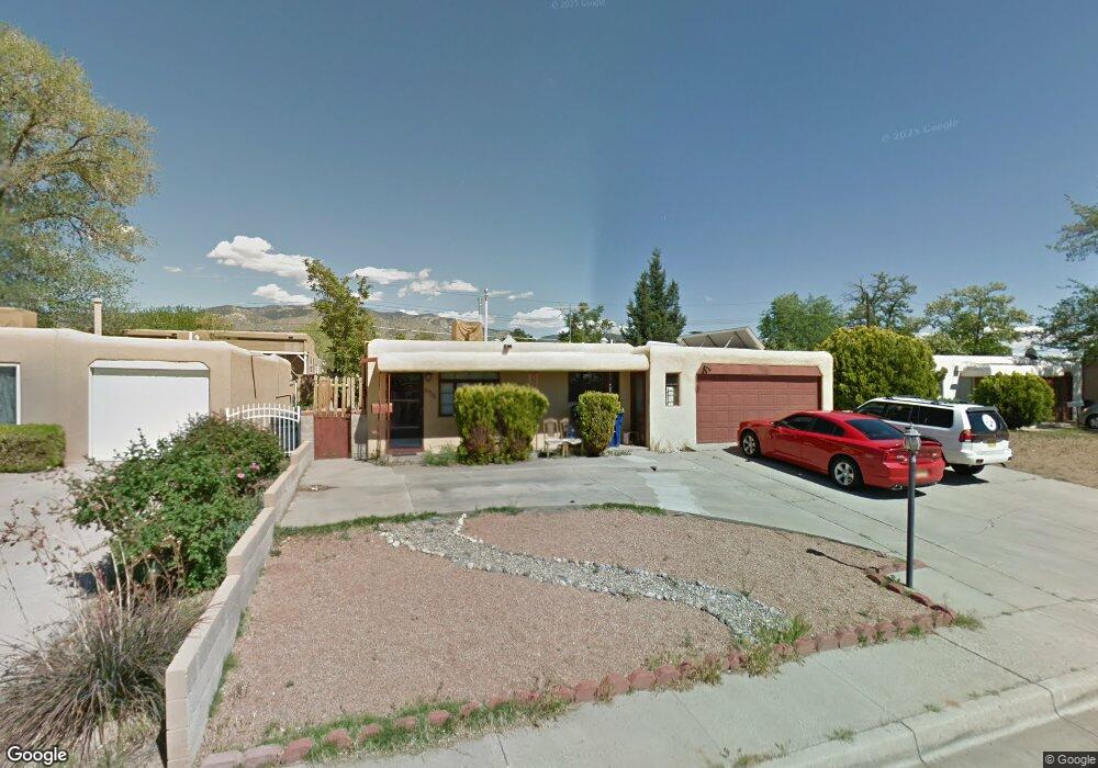
2712 Carol St NE Albuquerque, NM 87112
Northeast Heights NeighborhoodEstimated Value: $303,000 - $324,000
4
Beds
2
Baths
1,854
Sq Ft
$170/Sq Ft
Est. Value
About This Home
This home is located at 2712 Carol St NE, Albuquerque, NM 87112 and is currently estimated at $315,656, approximately $170 per square foot. 2712 Carol St NE is a home located in Bernalillo County with nearby schools including Eldorado High School, Matheson Park Elementary School, and Hoover Middle School.
Ownership History
Date
Name
Owned For
Owner Type
Purchase Details
Closed on
Oct 3, 2008
Sold by
Dossey Everett
Bought by
Bransford Steven Mark
Current Estimated Value
Purchase Details
Closed on
Aug 27, 2008
Sold by
Sunwest Trust Inc
Bought by
Bransford Steven
Purchase Details
Closed on
Feb 25, 2008
Sold by
Jaramillo Charlene and Woods Paula
Bought by
Sunwest Trust Inc and Rowe Land Trust
Create a Home Valuation Report for This Property
The Home Valuation Report is an in-depth analysis detailing your home's value as well as a comparison with similar homes in the area
Home Values in the Area
Average Home Value in this Area
Purchase History
| Date | Buyer | Sale Price | Title Company |
|---|---|---|---|
| Bransford Steven Mark | -- | None Available | |
| Bransford Steven | -- | Fidelity Natl Title Ins Co | |
| Sunwest Trust Inc | -- | None Available |
Source: Public Records
Tax History Compared to Growth
Tax History
| Year | Tax Paid | Tax Assessment Tax Assessment Total Assessment is a certain percentage of the fair market value that is determined by local assessors to be the total taxable value of land and additions on the property. | Land | Improvement |
|---|---|---|---|---|
| 2025 | $2,554 | $62,349 | $14,019 | $48,330 |
| 2024 | $2,554 | $60,534 | $13,611 | $46,923 |
| 2023 | $2,511 | $58,770 | $13,214 | $45,556 |
| 2022 | $2,427 | $57,060 | $12,830 | $44,230 |
| 2021 | $2,345 | $55,397 | $12,456 | $42,941 |
| 2020 | $2,307 | $53,784 | $12,093 | $41,691 |
| 2019 | $2,239 | $52,218 | $11,741 | $40,477 |
| 2018 | $2,160 | $52,218 | $11,741 | $40,477 |
| 2017 | $2,093 | $50,698 | $11,400 | $39,298 |
| 2016 | $2,033 | $47,787 | $10,745 | $37,042 |
| 2015 | $46,395 | $46,395 | $10,432 | $35,963 |
| 2014 | $1,967 | $46,314 | $10,609 | $35,705 |
| 2013 | -- | $44,965 | $10,300 | $34,665 |
Source: Public Records
Map
Nearby Homes
- 2805 Christine St NE
- 2700 Eubank Blvd NE
- 2417 Britt St NE
- 2329 Britt St NE
- 9521 Salem Rd NE
- 3110 Betts Dr NE
- 9916 Toltec Rd NE
- 10410 Towner Ave NE
- 2904 June St NE
- 2905 Dorothy St NE
- 3125 Lori Place NE
- 10708 Lexington Ave NE
- 3509 Glorieta St NE
- 9206 Aztec Rd NE
- 3612 Pitt St NE
- 9521 Snow Heights Blvd NE
- 3604 Piermont Dr NE
- 8922 Claremont Ave NE
- 3704 Glorieta St NE
- 9004 Shoshone Rd NE
- 2716 Carol St NE
- 2708 Carol St NE
- 2705 Christine St NE
- 2709 Christine St NE
- 2701 Christine St NE
- 2704 Carol St NE
- 2800 Carol St NE
- 2629 Christine St NE
- 2717 Carol St NE
- 2713 Carol St NE
- 2713 Christine St NE
- 2709 Carol St NE
- 2700 Carol St NE
- 2801 Carol St NE
- 2804 Carol St NE
- 2705 Carol St NE
- 2801 Christine St NE
- 2625 Christine St NE
- 2805 Carol St NE
- 2700 Christine St NE