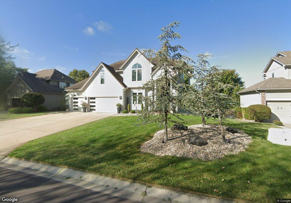
2732 SW Arthur Dr Lees Summit, MO 64082
Estimated Value: $457,055 - $565,000
4
Beds
3
Baths
2,833
Sq Ft
$183/Sq Ft
Est. Value
About This Home
This home is located at 2732 SW Arthur Dr, Lees Summit, MO 64082 and is currently estimated at $519,264, approximately $183 per square foot. 2732 SW Arthur Dr is a home located in Jackson County with nearby schools including Hawthorn Hill Elementary School, Summit Lakes Middle School, and Lee's Summit West High School.
Ownership History
Date
Name
Owned For
Owner Type
Purchase Details
Closed on
Jul 25, 2022
Sold by
Peck and Shellie
Bought by
Michael And Shellie Peck Revocable Trust
Current Estimated Value
Purchase Details
Closed on
Jun 17, 2022
Sold by
Peck Michael K and Peck Sheltie R
Bought by
Michael And Sheltie Peck Revocable Trust
Purchase Details
Closed on
Jan 6, 2000
Sold by
Spellerberg Construction Inc
Bought by
Peck Michael K and Peck Shellie R
Home Financials for this Owner
Home Financials are based on the most recent Mortgage that was taken out on this home.
Original Mortgage
$230,900
Interest Rate
7.76%
Mortgage Type
Purchase Money Mortgage
Create a Home Valuation Report for This Property
The Home Valuation Report is an in-depth analysis detailing your home's value as well as a comparison with similar homes in the area
Home Values in the Area
Average Home Value in this Area
Purchase History
| Date | Buyer | Sale Price | Title Company |
|---|---|---|---|
| Michael And Shellie Peck Revocable Trust | -- | None Listed On Document | |
| Michael And Sheltie Peck Revocable Trust | -- | None Listed On Document | |
| Peck Michael K | -- | Security Land Title Company |
Source: Public Records
Mortgage History
| Date | Status | Borrower | Loan Amount |
|---|---|---|---|
| Previous Owner | Peck Michael K | $230,900 | |
| Closed | Peck Michael K | $20,000 |
Source: Public Records
Tax History
| Year | Tax Paid | Tax Assessment Tax Assessment Total Assessment is a certain percentage of the fair market value that is determined by local assessors to be the total taxable value of land and additions on the property. | Land | Improvement |
|---|---|---|---|---|
| 2025 | $7,140 | $79,403 | $11,402 | $68,001 |
| 2024 | $7,088 | $98,887 | $6,333 | $92,554 |
| 2023 | $7,088 | $98,888 | $17,129 | $81,759 |
| 2022 | $4,847 | $60,040 | $5,330 | $54,710 |
| 2021 | $4,947 | $60,040 | $5,330 | $54,710 |
| 2020 | $4,758 | $57,180 | $5,330 | $51,850 |
| 2019 | $4,628 | $57,180 | $5,330 | $51,850 |
| 2018 | $4,589 | $52,622 | $6,197 | $46,425 |
| 2017 | $4,589 | $52,622 | $6,197 | $46,425 |
| 2016 | $4,550 | $51,642 | $5,377 | $46,265 |
Source: Public Records
Map
Nearby Homes
- 2707 SW Arthur Dr
- 2413 SW Kenwill Dr
- 2716 SW Regal Dr
- 2233 SW Crown Dr
- 2234 SW Heartland Ct
- 2230 SW Crown Dr
- 2712 SW Carlton Dr
- 2233 SW Heartland Ct
- 2750 SW Heartland Rd
- 2229 SW Heartland Ct
- 2218 SW Heartland Ct
- 2809 SW Heartland Rd
- 2213 SW Heartland Ct
- 2825 SW Heartland Rd
- 2516 SW Current Ln
- 2202 SW Hook Farm Dr
- 2317 SW Morris Dr
- 2314 SW Serena Place
- 3130 SW Blue Ribbon St
- 3116 SW Summit View Trail
- 2728 SW Arthur Dr
- 2800 SW Arthur Dr
- 2336 SW Crown Dr
- 2727 SW Arthur Dr
- 2724 SW Arthur Dr
- 2804 SW Arthur Dr
- 2723 SW Arthur Dr
- 2333 SW Crown Dr
- 2720 SW Arthur Dr
- 2808 SW Arthur Dr
- 2332 SW Crown Dr
- 2719 SW Arthur Dr
- 2716 SW Arthur Dr
- 2812 SW Arthur Dr
- 2329 SW Crown Dr
- 2328 SW Crown Dr
- 2316 SW Westminster Dr
- 2829 SW Carlton Dr
- 2821 SW Carlton Dr
- 2715 SW Arthur Dr
Your Personal Tour Guide
Ask me questions while you tour the home.