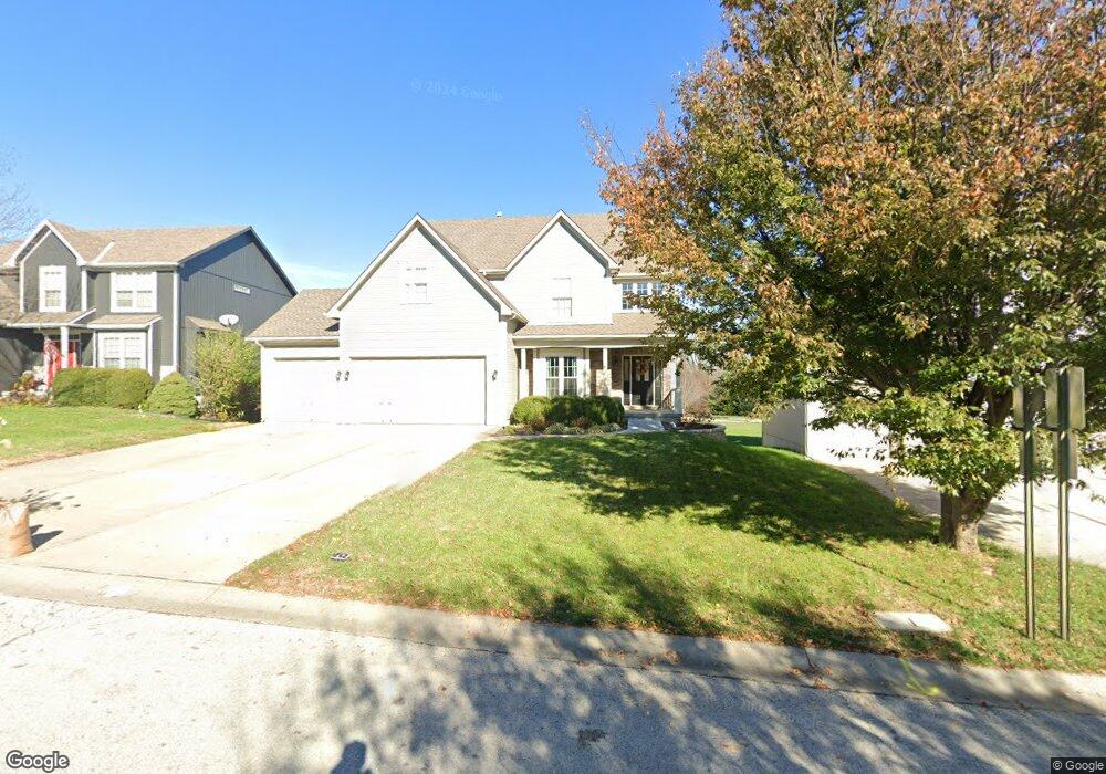
274 Ash Ln Lansing, KS 66043
Estimated Value: $378,000 - $432,000
5
Beds
4
Baths
2,554
Sq Ft
$163/Sq Ft
Est. Value
About This Home
This home is located at 274 Ash Ln, Lansing, KS 66043 and is currently estimated at $415,219, approximately $162 per square foot. 274 Ash Ln is a home located in Leavenworth County with nearby schools including Lansing Elementary School, Lansing Middle 6-8, and Lansing High 9-12.
Ownership History
Date
Name
Owned For
Owner Type
Purchase Details
Closed on
May 1, 2003
Bought by
Jenkins Brooks A and Jenkins Stacey
Current Estimated Value
Home Financials for this Owner
Home Financials are based on the most recent Mortgage that was taken out on this home.
Original Mortgage
$188,000
Outstanding Balance
$81,708
Interest Rate
5.79%
Mortgage Type
New Conventional
Estimated Equity
$333,511
Create a Home Valuation Report for This Property
The Home Valuation Report is an in-depth analysis detailing your home's value as well as a comparison with similar homes in the area
Home Values in the Area
Average Home Value in this Area
Purchase History
| Date | Buyer | Sale Price | Title Company |
|---|---|---|---|
| Jenkins Brooks A | $218,000 | -- |
Source: Public Records
Mortgage History
| Date | Status | Borrower | Loan Amount |
|---|---|---|---|
| Open | Jenkins Brooks A | $188,000 | |
| Closed | Jenkins Brooks A | $183,200 |
Source: Public Records
Tax History Compared to Growth
Tax History
| Year | Tax Paid | Tax Assessment Tax Assessment Total Assessment is a certain percentage of the fair market value that is determined by local assessors to be the total taxable value of land and additions on the property. | Land | Improvement |
|---|---|---|---|---|
| 2025 | $6,635 | $50,796 | $5,887 | $44,909 |
| 2024 | $6,287 | $48,921 | $5,887 | $43,034 |
| 2023 | $6,287 | $48,162 | $5,887 | $42,275 |
| 2022 | $5,761 | $41,757 | $3,675 | $38,082 |
| 2021 | $5,291 | $36,673 | $3,675 | $32,998 |
| 2020 | $5,021 | $34,258 | $3,675 | $30,583 |
| 2019 | $4,960 | $33,798 | $3,675 | $30,123 |
| 2018 | $4,879 | $33,269 | $3,675 | $29,594 |
| 2017 | $4,674 | $31,813 | $3,675 | $28,138 |
| 2016 | $4,630 | $31,498 | $3,675 | $27,823 |
| 2015 | $4,706 | $32,108 | $3,675 | $28,433 |
| 2014 | $4,481 | $31,222 | $3,675 | $27,547 |
Source: Public Records
Map
Nearby Homes
- 722 Bittersweet Rd
- 922 Southfork St
- 624 S Bittersweet Ln
- 901 S Main St
- 527 S Valley Dr
- 115 W Gilman Rd
- 811 4-H Rd
- 104 Olive St
- 506 1st Terrace
- 000 4-H Rd
- 131 Rock Creek Loop
- 202 S Main St
- 875 Clearview Dr
- 124 S Main St
- 102 S 3rd Ct
- 705 Rock Creek Dr
- 1221 S Desoto Rd
- 833 Rock Creek Dr
- 218 E Kay St
- 209 E Kay St