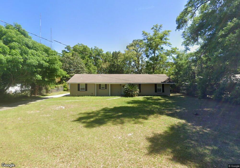
2747 Robin Rd Jacksonville, FL 32216
Sans Souci NeighborhoodEstimated Value: $288,000 - $387,000
3
Beds
1
Bath
1,572
Sq Ft
$206/Sq Ft
Est. Value
About This Home
This home is located at 2747 Robin Rd, Jacksonville, FL 32216 and is currently estimated at $323,635, approximately $205 per square foot. 2747 Robin Rd is a home located in Duval County with nearby schools including Hogan-Spring Glen Elementary School, Southside Middle School, and Englewood High School.
Ownership History
Date
Name
Owned For
Owner Type
Purchase Details
Closed on
Sep 26, 2013
Sold by
Blankenship Bart Martin
Bought by
Lehmbeck Kevin
Current Estimated Value
Purchase Details
Closed on
Jan 18, 2011
Sold by
The Secretary Of Veterans Affairs
Bought by
Blankenship Bart Martin
Purchase Details
Closed on
Aug 3, 2010
Sold by
Leist Rodney A and Leist Denise L
Bought by
The Secretary Of Veterans Affairs
Purchase Details
Closed on
Jul 21, 2010
Sold by
Leist Rodney A and Leist Denise L
Bought by
Bac Home Loans Servicing Lp
Create a Home Valuation Report for This Property
The Home Valuation Report is an in-depth analysis detailing your home's value as well as a comparison with similar homes in the area
Home Values in the Area
Average Home Value in this Area
Purchase History
| Date | Buyer | Sale Price | Title Company |
|---|---|---|---|
| Lehmbeck Kevin | $12,900 | All Florida Title Services I | |
| Blankenship Bart Martin | $12,900 | All Florida Title Svcs Inc | |
| The Secretary Of Veterans Affairs | -- | Attorney | |
| Bac Home Loans Servicing Lp | -- | Attorney |
Source: Public Records
Tax History
| Year | Tax Paid | Tax Assessment Tax Assessment Total Assessment is a certain percentage of the fair market value that is determined by local assessors to be the total taxable value of land and additions on the property. | Land | Improvement |
|---|---|---|---|---|
| 2026 | $2,281 | $153,465 | -- | -- |
| 2025 | $2,141 | $153,465 | -- | -- |
| 2024 | $2,075 | $149,140 | -- | -- |
| 2023 | $2,075 | $144,797 | $0 | $0 |
| 2022 | $1,892 | $140,580 | $0 | $0 |
| 2021 | $1,871 | $136,486 | $0 | $0 |
| 2020 | $1,849 | $134,602 | $0 | $0 |
| 2019 | $1,823 | $131,576 | $0 | $0 |
| 2018 | $1,795 | $129,123 | $0 | $0 |
| 2017 | $1,768 | $126,468 | $0 | $0 |
| 2016 | $1,753 | $123,867 | $0 | $0 |
| 2015 | $1,769 | $123,006 | $0 | $0 |
| 2014 | $1,770 | $122,030 | $0 | $0 |
Source: Public Records
Map
Nearby Homes
- 8449 Newton Rd
- 2823 Jewell Rd
- 8223 Brackridge Blvd S
- 8261 Brackridge Blvd S
- 2917 Parr Ct W
- 2736 Jewell Rd
- 2809 Parr Ct E
- 8441 Newton (Lot 3) Rd
- 7787 Hilsdale Rd
- 2916 Brackridge Blvd E
- 2085 Mills Rd
- 3056 Bridgeview Dr
- 2806 Hilsdale Harbor Way
- 3101 Old Port Cir E
- 8080 Ibach Rd
- 3452 Killarney Dr
- 8628 Blarney Stone Ct
- 2323 Parental Home Rd
- 8468 Climbing Ivy Trail S
- 3842 Ruby Dr W
- 2733 Robin Rd
- 2761 Robin Rd
- 2771 Robin Rd
- 2719 Robin Rd
- 2734 Belfort Rd
- 2746 Robin Rd
- 2772 Belfort Rd
- 2732 Robin Rd
- 2789 Robin Rd
- 2760 Robin Rd
- 2720 Belfort Rd
- 8610 Synhoff Dr
- 2718 Robin Rd
- 0 Newton Rd Unit 1025696
- 0 Newton Rd
- 8630 Synhoff Dr
- 8520 Synhoff Dr
- 2792 Robin Rd
- 2757 Belfort Rd
- 8174 Newton Rd
Your Personal Tour Guide
Ask me questions while you tour the home.