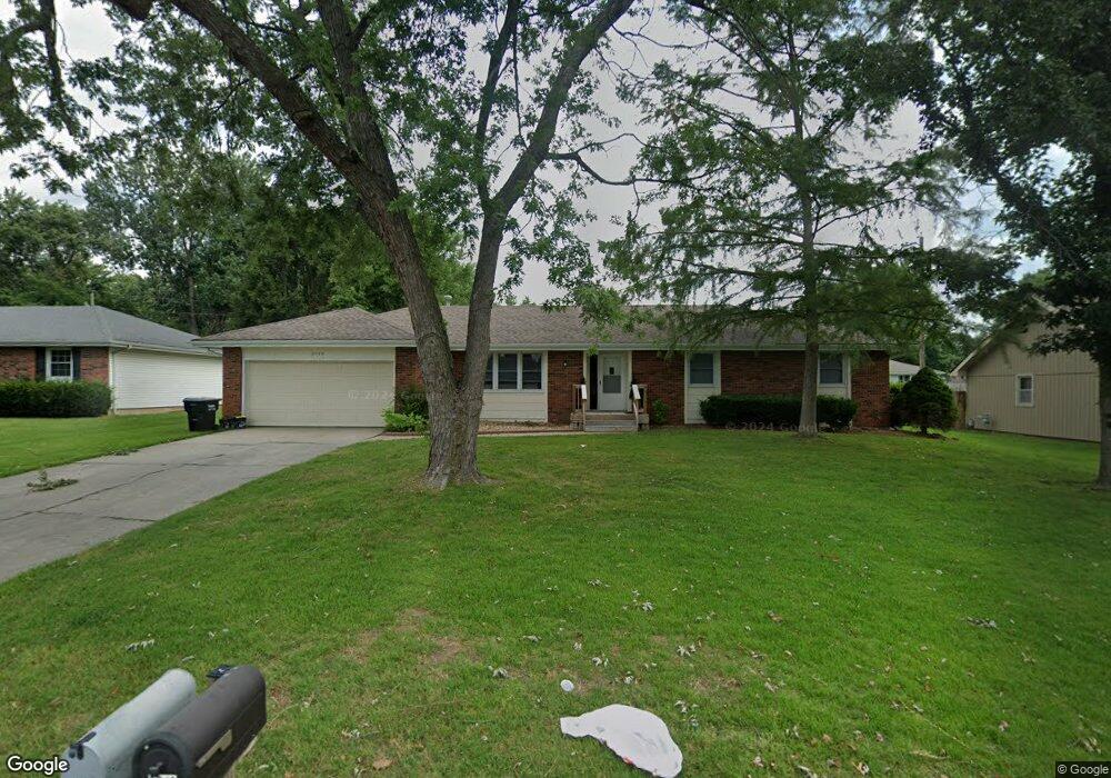
2749 W Buena Vista St Springfield, MO 65810
Southwest Springfield NeighborhoodEstimated Value: $248,043 - $277,000
3
Beds
2
Baths
1,810
Sq Ft
$143/Sq Ft
Est. Value
About This Home
This home is located at 2749 W Buena Vista St, Springfield, MO 65810 and is currently estimated at $258,011, approximately $142 per square foot. 2749 W Buena Vista St is a home located in Greene County with nearby schools including David Harrison Elementary School, Wilson's Creek Intermediate School, and Cherokee Middle School.
Ownership History
Date
Name
Owned For
Owner Type
Purchase Details
Closed on
Apr 15, 2008
Sold by
Gilmore Tanja
Bought by
Carlson Robert A
Current Estimated Value
Purchase Details
Closed on
Oct 13, 2005
Sold by
Frye Louis Michael
Bought by
Gilmore Tanja
Home Financials for this Owner
Home Financials are based on the most recent Mortgage that was taken out on this home.
Original Mortgage
$23,200
Interest Rate
5.73%
Mortgage Type
Stand Alone Second
Create a Home Valuation Report for This Property
The Home Valuation Report is an in-depth analysis detailing your home's value as well as a comparison with similar homes in the area
Home Values in the Area
Average Home Value in this Area
Purchase History
| Date | Buyer | Sale Price | Title Company |
|---|---|---|---|
| Carlson Robert A | $87,050 | None Available | |
| Gilmore Tanja | -- | None Available |
Source: Public Records
Mortgage History
| Date | Status | Borrower | Loan Amount |
|---|---|---|---|
| Previous Owner | Gilmore Tanja | $23,200 | |
| Previous Owner | Gilmore Tanja | $92,800 |
Source: Public Records
Tax History Compared to Growth
Tax History
| Year | Tax Paid | Tax Assessment Tax Assessment Total Assessment is a certain percentage of the fair market value that is determined by local assessors to be the total taxable value of land and additions on the property. | Land | Improvement |
|---|---|---|---|---|
| 2025 | $1,251 | $26,240 | $7,130 | $19,110 |
| 2024 | $1,251 | $22,590 | $4,750 | $17,840 |
| 2023 | $1,244 | $22,590 | $4,750 | $17,840 |
| 2022 | $1,111 | $20,670 | $4,750 | $15,920 |
| 2021 | $1,111 | $20,670 | $4,750 | $15,920 |
| 2020 | $1,076 | $18,980 | $4,750 | $14,230 |
| 2019 | $1,045 | $18,980 | $4,750 | $14,230 |
| 2018 | $1,036 | $18,770 | $4,750 | $14,020 |
| 2017 | $1,025 | $17,440 | $4,750 | $12,690 |
| 2016 | $953 | $17,440 | $4,750 | $12,690 |
| 2015 | $945 | $17,440 | $4,750 | $12,690 |
| 2014 | $924 | $16,910 | $4,750 | $12,160 |
Source: Public Records
Map
Nearby Homes
- 2683 W Buena Vista St
- 4342 S Deborah Rd
- 2852 W Republic Rd
- 4622 S West Ave
- 4640 S Leroy Ave
- 4654 S Farm Road 135
- 2651 W Alta St
- 2812 W Maplewood St
- 3032 W Allen Dr
- 3021 W Allen Dr
- 2983 W Teton Dr
- 3039 W Teton Dr
- 3017 W Teton Dr
- 4688 S Forest Ave
- 2177 W Glen Gary Ct
- 2398 W Allen Dr
- 2175 W Glen Gary Ct
- 4566 S Park Ave
- 2642 W Blakey St
- 3005 W Teton Dr
- 2759 W Buena Vista St
- 2741 W Buena Vista St
- 2750 W Camino Alto St
- 2760 W Camino Alto St
- 2740 W Camino Alto St
- 2750 W Buena Vista St
- 2769 W Buena Vista St
- 2740 W Buena Vista St
- 2758 W Buena Vista St
- 2768 W Camino Alto St
- 4446 S Holiday Ave
- 2768 W Buena Vista St
- 4436 S Holiday Ave
- 2779 W Buena Vista St
- 4456 S Holiday Ave
- 4426 S Holiday Ave
- 2778 W Camino Alto St
- 2749 W Village Terrace
- 2745 W Camino Alto St
- 2741 W Village Terrace