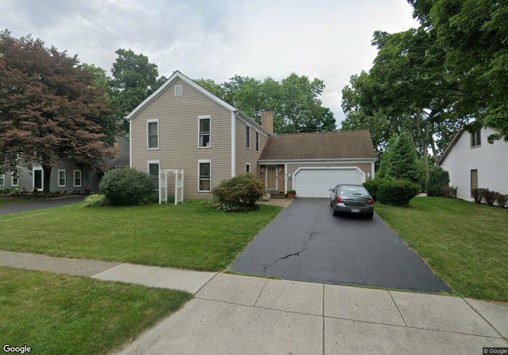
275 Longbranch Dr Dublin, OH 43017
Estimated Value: $493,233 - $598,000
4
Beds
3
Baths
2,200
Sq Ft
$247/Sq Ft
Est. Value
About This Home
This home is located at 275 Longbranch Dr, Dublin, OH 43017 and is currently estimated at $543,808, approximately $247 per square foot. 275 Longbranch Dr is a home located in Franklin County with nearby schools including Indian Run Elementary School, John Sells Middle School, and Dublin Coffman High School.
Ownership History
Date
Name
Owned For
Owner Type
Purchase Details
Closed on
Sep 19, 2022
Sold by
Johnson Steven H
Bought by
Johnson Shelley D
Current Estimated Value
Purchase Details
Closed on
Aug 18, 1999
Sold by
Barney Eppie and Barney Sharron
Bought by
Johnson Steven H and Johnson Shelley D
Home Financials for this Owner
Home Financials are based on the most recent Mortgage that was taken out on this home.
Original Mortgage
$147,500
Interest Rate
7.7%
Purchase Details
Closed on
Nov 22, 1989
Bought by
Benson Sharron R
Purchase Details
Closed on
Nov 15, 1989
Purchase Details
Closed on
Oct 1, 1985
Create a Home Valuation Report for This Property
The Home Valuation Report is an in-depth analysis detailing your home's value as well as a comparison with similar homes in the area
Home Values in the Area
Average Home Value in this Area
Purchase History
| Date | Buyer | Sale Price | Title Company |
|---|---|---|---|
| Johnson Shelley D | -- | -- | |
| Johnson Steven H | $167,500 | Midland Title Security Inc | |
| Barney Eppie | -- | Midland Title Security Inc | |
| Benson Sharron R | $148,000 | -- | |
| -- | $151,000 | -- | |
| -- | $135,900 | -- |
Source: Public Records
Mortgage History
| Date | Status | Borrower | Loan Amount |
|---|---|---|---|
| Previous Owner | Johnson Steven H | $147,500 |
Source: Public Records
Tax History
| Year | Tax Paid | Tax Assessment Tax Assessment Total Assessment is a certain percentage of the fair market value that is determined by local assessors to be the total taxable value of land and additions on the property. | Land | Improvement |
|---|---|---|---|---|
| 2025 | $8,723 | $134,260 | $46,690 | $87,570 |
| 2024 | $8,723 | $134,260 | $46,690 | $87,570 |
| 2023 | $8,602 | $134,260 | $46,690 | $87,570 |
| 2022 | $7,205 | $102,800 | $26,780 | $76,020 |
| 2021 | $7,365 | $102,800 | $26,780 | $76,020 |
| 2020 | $7,283 | $102,800 | $26,780 | $76,020 |
| 2019 | $6,664 | $83,200 | $21,420 | $61,780 |
| 2018 | $6,763 | $83,200 | $21,420 | $61,780 |
| 2017 | $6,495 | $83,200 | $21,420 | $61,780 |
| 2016 | $6,789 | $85,510 | $21,880 | $63,630 |
| 2015 | $6,833 | $85,510 | $21,880 | $63,630 |
| 2014 | $6,841 | $85,510 | $21,880 | $63,630 |
| 2013 | $3,165 | $77,735 | $19,880 | $57,855 |
Source: Public Records
Map
Nearby Homes
- 295 Beckley Ln
- 105 Marion St
- 390 Edinburgh Rd
- 410 Edinburgh Rd Unit 410
- 438 Edinburgh Rd Unit 438-452
- 187 Stonefence Ln
- 6350 Frantz Rd
- 5850 Chatterfield Dr
- 180 S Riverview St
- 5622 Riverside Dr
- 6187 Water Bank St
- 3263 Scioto Ridge Rd
- 6171 Water Bank St
- 3223 Banting St
- 6802 Chesley Rd
- 6628 Brock St
- 5885 Ballymead Blvd
- 3118 Baffin Ct
- 5884 Parkbridge Ln Unit 193
- 3143 Brampton St
- 267 Longbranch Dr
- 291 Longbranch Dr
- 278 Longbranch Dr
- 259 Longbranch Dr
- 260 Longbranch Dr
- 286 Longbranch Dr
- 299 Longbranch Dr
- 294 Longbranch Dr
- 371 Pebble Creek Dr
- 366 Ashworth Ct
- 307 Longbranch Dr
- 302 Longbranch Dr
- 363 Pebble Creek Dr
- 315 Longbranch Dr
- 368 Avon Ct
- 363 Ashworth Ct
- 358 Ashworth Ct
- 355 Pebble Creek Dr
- 360 Avon Ct
- 323 Longbranch Dr
Your Personal Tour Guide
Ask me questions while you tour the home.