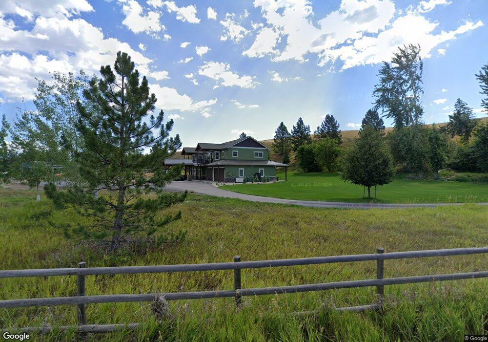
2750 Mccauley Ln Missoula, MT 59804
Estimated Value: $570,000 - $924,734
4
Beds
5
Baths
4,178
Sq Ft
$179/Sq Ft
Est. Value
About This Home
This home is located at 2750 Mccauley Ln, Missoula, MT 59804 and is currently estimated at $747,367, approximately $178 per square foot. 2750 Mccauley Ln is a home with nearby schools including Target Range School, Big Sky High School, and First Lutheran Classical School.
Ownership History
Date
Name
Owned For
Owner Type
Purchase Details
Closed on
Dec 5, 2019
Sold by
Jensen Tim A and Jensen Allan N
Bought by
Jensen Tim A and Jensen Victoria
Current Estimated Value
Purchase Details
Closed on
Aug 28, 2013
Sold by
Winterer Properties Llc
Bought by
Jensen Tim A and Jensen Allan N
Purchase Details
Closed on
Apr 1, 2005
Sold by
Montgomery Jolyn
Bought by
Winterer Properties Llc
Purchase Details
Closed on
May 28, 2002
Sold by
Dougherty Damien Rose Mcdonald and Mcdonald Terrance L
Bought by
Montgomery Jolyn
Create a Home Valuation Report for This Property
The Home Valuation Report is an in-depth analysis detailing your home's value as well as a comparison with similar homes in the area
Home Values in the Area
Average Home Value in this Area
Purchase History
| Date | Buyer | Sale Price | Title Company |
|---|---|---|---|
| Jensen Tim A | -- | None Available | |
| Jensen Tim A | -- | First American Title Company | |
| Winterer Properties Llc | -- | -- | |
| Montgomery Jolyn | -- | -- | |
| Montgomery Jolyn | -- | -- |
Source: Public Records
Tax History Compared to Growth
Tax History
| Year | Tax Paid | Tax Assessment Tax Assessment Total Assessment is a certain percentage of the fair market value that is determined by local assessors to be the total taxable value of land and additions on the property. | Land | Improvement |
|---|---|---|---|---|
| 2025 | $6,191 | $1,383,834 | $375,504 | $1,008,330 |
| 2024 | $6,963 | $622,900 | $294,120 | $328,780 |
| 2023 | $5,961 | $668,700 | $294,120 | $374,580 |
| 2022 | $6,383 | $589,900 | $0 | $0 |
| 2021 | $5,963 | $589,900 | $0 | $0 |
| 2020 | $5,351 | $506,800 | $0 | $0 |
| 2019 | $5,310 | $506,800 | $0 | $0 |
| 2018 | $5,119 | $498,614 | $0 | $0 |
| 2017 | $4,879 | $498,614 | $0 | $0 |
| 2016 | $1,626 | $151,584 | $0 | $0 |
| 2015 | $1,574 | $151,584 | $0 | $0 |
| 2014 | $1,669 | $90,113 | $0 | $0 |
Source: Public Records
Map
Nearby Homes
- 2222 Pauline Dr
- Nhn 40th Ave
- 3101 Humble Rd
- 2275 Ruth Louise Ln
- 4230 North Ave W
- 4316 North Ave W
- 2201 Rafferty Ln
- 1522 Clements Rd
- 3522 South Ave W
- 2311 Tower St
- 3720 Sierra Dr
- 1211 Kenwood Dr
- 4474 Blue Mountain Rd
- 1085 Spurgin Ct
- 296 Big Flat Rd
- 4600 Tiberius Dr
- 4669 Langdon Ct
- 325 Big Flat Rd
- 4967 Buckhouse Ln
- NHN Howard St
- 4252 Sundown Rd
- 4235 Sundown Rd
- na Mc Cauley Ln
- 2615 Gunsight Ct
- 4261 Sundown Rd
- 2526 Mccauley Ln
- 2526 Mccauley Ln
- 2840 Ringo Dr
- 2555 Gunsight Ct
- 2876 Ringo Dr
- 2876 Ringo Dr
- 2712 Glen Dr
- 2541 Mc Cauley Ln
- 2704 Glen Dr
- 2620 Glen Dr
- 2625 Mccauley Ln
- 4285 Sundown Rd
- 2612 Glen Dr
- 2550 Gunsight Ct
- 2515 Gunsight Ct