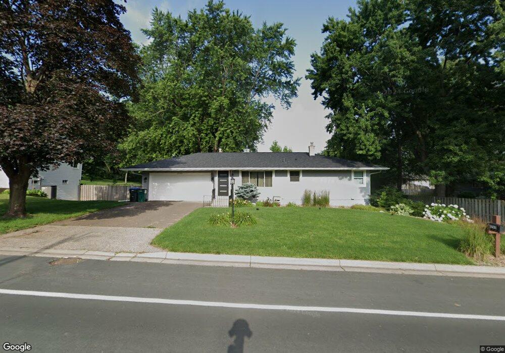
2783 Dale St N Saint Paul, MN 55113
South Owasso NeighborhoodEstimated Value: $410,210 - $439,000
4
Beds
2
Baths
2,200
Sq Ft
$193/Sq Ft
Est. Value
About This Home
This home is located at 2783 Dale St N, Saint Paul, MN 55113 and is currently estimated at $424,053, approximately $192 per square foot. 2783 Dale St N is a home located in Ramsey County with nearby schools including Emmet D. Williams Elementary School, Roseville Area Middle School, and Roseville Area Senior High School.
Ownership History
Date
Name
Owned For
Owner Type
Purchase Details
Closed on
Nov 5, 2021
Sold by
Golden Michael Charles
Bought by
Golden Michael Charles and Stokes Megan Marie
Current Estimated Value
Purchase Details
Closed on
Mar 9, 2021
Sold by
Wilson Benjamin M and Wilson Nicole J
Bought by
Golden Michael and Stockes Megan
Home Financials for this Owner
Home Financials are based on the most recent Mortgage that was taken out on this home.
Original Mortgage
$328,500
Interest Rate
2.8%
Mortgage Type
New Conventional
Purchase Details
Closed on
Mar 20, 2017
Sold by
Bogie David M and Bogie Christine E
Bought by
Wilson Benjamarnin M and Wilson Nicole J
Home Financials for this Owner
Home Financials are based on the most recent Mortgage that was taken out on this home.
Original Mortgage
$264,900
Interest Rate
4.87%
Mortgage Type
Adjustable Rate Mortgage/ARM
Create a Home Valuation Report for This Property
The Home Valuation Report is an in-depth analysis detailing your home's value as well as a comparison with similar homes in the area
Home Values in the Area
Average Home Value in this Area
Purchase History
| Date | Buyer | Sale Price | Title Company |
|---|---|---|---|
| Golden Michael Charles | -- | None Listed On Document | |
| Golden Michael | $365,000 | Burnet Title | |
| Wilson Benjamarnin M | $264,894 | Burnet Title | |
| Golden Michael Michael | $365,000 | -- |
Source: Public Records
Mortgage History
| Date | Status | Borrower | Loan Amount |
|---|---|---|---|
| Previous Owner | Golden Michael | $328,500 | |
| Previous Owner | Wilson Benjamarnin M | $264,900 | |
| Closed | Golden Michael Michael | $318,480 |
Source: Public Records
Tax History Compared to Growth
Tax History
| Year | Tax Paid | Tax Assessment Tax Assessment Total Assessment is a certain percentage of the fair market value that is determined by local assessors to be the total taxable value of land and additions on the property. | Land | Improvement |
|---|---|---|---|---|
| 2025 | $5,488 | $401,100 | $95,000 | $306,100 |
| 2023 | $5,488 | $389,800 | $85,500 | $304,300 |
| 2022 | $4,642 | $352,800 | $85,500 | $267,300 |
| 2021 | $4,418 | $313,900 | $85,500 | $228,400 |
| 2020 | $4,404 | $318,900 | $76,000 | $242,900 |
| 2019 | $3,904 | $299,500 | $76,000 | $223,500 |
| 2018 | $3,604 | $262,000 | $81,500 | $180,500 |
| 2017 | $3,604 | $238,200 | $81,500 | $156,700 |
| 2016 | $3,550 | $0 | $0 | $0 |
| 2015 | $3,510 | $222,800 | $79,100 | $143,700 |
| 2014 | $3,338 | $0 | $0 | $0 |
Source: Public Records
Map
Nearby Homes
- 2748 Kent St
- 540 Woodhill Dr Unit 71
- 613 S Owasso Blvd W
- 2730 Dale St N Unit D101
- 2730 Dale St N Unit D309
- 2720 Dale St N Unit C208
- 667 County Road C W
- 2710 Dale St N Unit B212
- 2720 MacKubin St
- 556 County Road C W
- 437 County Road C W
- 405 Judith Ave
- 387 Iona Ln
- 2870 Victoria St N
- 2860 Victoria St N
- Ashby Plan at Victoria Shores
- 932 Orchard Ln
- 2970 Western Ave N
- 350 County Road C W
- 2580 Western Ave N