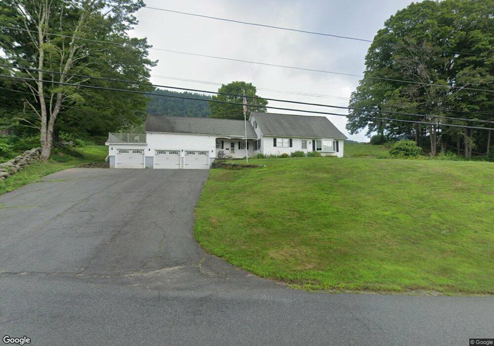
28 Bray Rd Shelburne Falls, MA 01370
Buckland NeighborhoodEstimated Value: $430,000 - $547,000
3
Beds
2
Baths
2,204
Sq Ft
$215/Sq Ft
Est. Value
About This Home
This home is located at 28 Bray Rd, Shelburne Falls, MA 01370 and is currently estimated at $474,753, approximately $215 per square foot. 28 Bray Rd is a home with nearby schools including Mohawk Trail Regional High School.
Ownership History
Date
Name
Owned For
Owner Type
Purchase Details
Closed on
Sep 11, 2023
Sold by
Walker William T Est and Harris
Bought by
Walker Credit Shelter T and Harris
Current Estimated Value
Purchase Details
Closed on
Jan 20, 2023
Sold by
William T Walker Int T and William Walker
Bought by
Walker William T
Purchase Details
Closed on
Dec 6, 2018
Sold by
Walker William T and Walker Diane A
Bought by
William T Walker Int T and William Walker
Create a Home Valuation Report for This Property
The Home Valuation Report is an in-depth analysis detailing your home's value as well as a comparison with similar homes in the area
Home Values in the Area
Average Home Value in this Area
Purchase History
| Date | Buyer | Sale Price | Title Company |
|---|---|---|---|
| Walker Credit Shelter T | -- | None Available | |
| Walker William T | -- | None Available | |
| William T Walker Int T | -- | -- |
Source: Public Records
Tax History Compared to Growth
Tax History
| Year | Tax Paid | Tax Assessment Tax Assessment Total Assessment is a certain percentage of the fair market value that is determined by local assessors to be the total taxable value of land and additions on the property. | Land | Improvement |
|---|---|---|---|---|
| 2025 | $7,135 | $421,200 | $60,900 | $360,300 |
| 2024 | $7,008 | $399,100 | $60,900 | $338,200 |
| 2023 | $6,148 | $362,900 | $60,900 | $302,000 |
| 2022 | $6,089 | $362,900 | $60,900 | $302,000 |
| 2021 | $5,769 | $323,400 | $60,900 | $262,500 |
| 2020 | $5,634 | $304,200 | $60,900 | $243,300 |
| 2019 | $5,336 | $286,400 | $60,900 | $225,500 |
| 2018 | $5,197 | $275,700 | $60,900 | $214,800 |
| 2017 | $4,976 | $275,700 | $60,900 | $214,800 |
| 2016 | $4,642 | $274,700 | $60,900 | $213,800 |
| 2015 | $4,615 | $274,700 | $60,900 | $213,800 |
Source: Public Records
Map
Nearby Homes
- 102 Elm St
- 10 Deerfield Ave Unit 5
- 10 Deerfield Ave Unit 2
- 33 Williams St
- 105 - 107 Bridge St
- 2151 Route 2
- 2155 Massachusetts 2
- 7 Hog Hollow Rd
- 156 Ashfield Rd
- 0 Upper St
- 31 W Oxbow Rd
- 24 W Oxbow Rd
- 0 Ashfield Rd
- 0 W Oxbow Rd Unit 73453651
- 85 Dacey Rd
- lot 1 Shelburne Falls Rd
- 240 Beldingville Rd
- 143 Charlemont Rd
- 3+5 Church St
- 0 Fiske Mill Rd