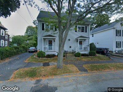
28 Park St Unit 28B Wakefield, MA 01880
Lakeside NeighborhoodEstimated Value: $801,000 - $1,112,989
6
Beds
2
Baths
3,306
Sq Ft
$291/Sq Ft
Est. Value
About This Home
This home is located at 28 Park St Unit 28B, Wakefield, MA 01880 and is currently estimated at $963,497, approximately $291 per square foot. 28 Park St Unit 28B is a home located in Middlesex County with nearby schools including Wakefield Memorial High School, St Joseph School, and Odyssey Day School.
Ownership History
Date
Name
Owned For
Owner Type
Purchase Details
Closed on
Feb 21, 2025
Sold by
Obrien Mark J and Obrien Maureen A
Bought by
Mark & Maureen Obrien Ret and Obrien
Current Estimated Value
Purchase Details
Closed on
May 26, 1994
Sold by
Danforth Steven P and Blanton Edna M
Bought by
Carbone William M and Carbone Marilyn
Home Financials for this Owner
Home Financials are based on the most recent Mortgage that was taken out on this home.
Original Mortgage
$95,000
Interest Rate
8.22%
Mortgage Type
Purchase Money Mortgage
Purchase Details
Closed on
Jun 11, 1993
Sold by
Skiru Rt and Cleveland Clayton
Bought by
Danforth Steven P and Blanton Edna M
Create a Home Valuation Report for This Property
The Home Valuation Report is an in-depth analysis detailing your home's value as well as a comparison with similar homes in the area
Home Values in the Area
Average Home Value in this Area
Purchase History
| Date | Buyer | Sale Price | Title Company |
|---|---|---|---|
| Mark & Maureen Obrien Ret | -- | None Available | |
| Mark & Maureen Obrien Ret | -- | None Available | |
| Carbone William M | $240,000 | -- | |
| Carbone William M | $240,000 | -- | |
| Danforth Steven P | $115,000 | -- | |
| Danforth Steven P | $115,000 | -- |
Source: Public Records
Mortgage History
| Date | Status | Borrower | Loan Amount |
|---|---|---|---|
| Previous Owner | Obrien Mark J | $534,000 | |
| Previous Owner | Carbone William M | $200,000 | |
| Previous Owner | Danforth Steven P | $95,000 |
Source: Public Records
Tax History Compared to Growth
Tax History
| Year | Tax Paid | Tax Assessment Tax Assessment Total Assessment is a certain percentage of the fair market value that is determined by local assessors to be the total taxable value of land and additions on the property. | Land | Improvement |
|---|---|---|---|---|
| 2025 | $10,876 | $958,200 | $374,200 | $584,000 |
| 2024 | $10,983 | $976,300 | $381,300 | $595,000 |
| 2023 | $10,436 | $889,700 | $347,400 | $542,300 |
| 2022 | $9,701 | $787,400 | $307,500 | $479,900 |
| 2021 | $8,894 | $698,700 | $284,100 | $414,600 |
| 2020 | $8,263 | $647,100 | $263,100 | $384,000 |
| 2019 | $7,967 | $621,000 | $252,500 | $368,500 |
| 2018 | $7,576 | $585,000 | $237,900 | $347,100 |
| 2017 | $7,226 | $554,600 | $225,500 | $329,100 |
| 2016 | $6,691 | $496,000 | $206,400 | $289,600 |
| 2015 | $6,561 | $486,700 | $202,500 | $284,200 |
| 2014 | $5,981 | $468,000 | $194,700 | $273,300 |
Source: Public Records
Map
Nearby Homes
- 39 Pleasant St
- 3 Rockland St
- 44 Salem St Unit C
- 20 Lawrence St Unit 3
- 13 Chestnut St Unit 2
- 13 Chestnut St Unit 1
- 10 Foster St Unit 306
- 10 Foster St Unit 203
- 11 Spaulding St Unit 2
- 3 Richardson St Unit C6
- 24 Armory St
- 50 Tuttle St Unit 10
- 80 Preston St Unit 2
- 80 Preston St Unit 1
- 18 Eastern Ave
- 62 Foundry St Unit 411
- 62 Foundry St Unit 406
- 62 Foundry St Unit 508
- 62 Foundry St Unit 311
- 62 Foundry St Unit 312