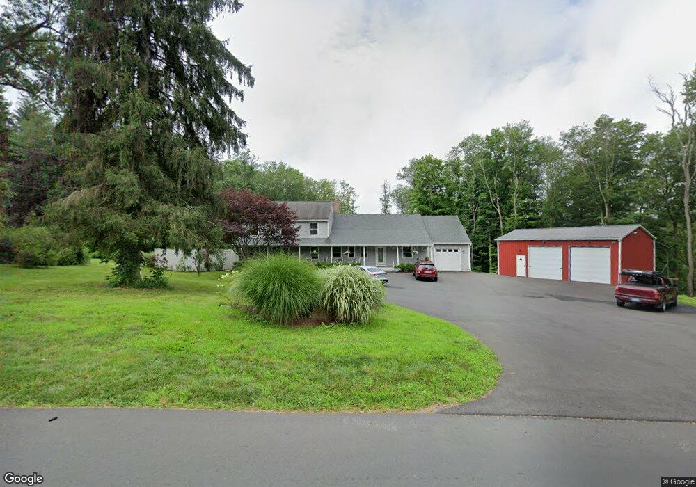
280 Maple Ave Durham, CT 06422
Estimated Value: $453,000 - $657,000
About This Home
This home is located at 280 Maple Ave, Durham, CT 06422 and is currently estimated at $536,101, approximately $169 per square foot. 280 Maple Ave is a home located in Middlesex County with nearby schools including Frank Ward Strong School, Coginchaug Regional High School, and The Independent Day School.
Ownership History
We collect this data history from publicly available records. To have your information removed, we recommend requesting removal directly through your county’s website.
Purchase Details
Purchase Details
Home Values in the Area
Average Home Value in this Area
Purchase History
We collect this data history from publicly available records. To have your information removed, we recommend requesting removal directly through your county’s website.
| Date | Buyer | Sale Price | Title Company |
|---|---|---|---|
| -- | None Available | ||
| $240,000 | -- |
Mortgage History
We collect this data history from publicly available records. To have your information removed, we recommend requesting removal directly through your county’s website.
| Date | Status | Borrower | Loan Amount |
|---|---|---|---|
| Closed | $40,000 | ||
| Closed | $12,000 |
Tax History
We collect this data history from publicly available records. To have your information removed, we recommend requesting removal directly through your county’s website.
| Year | Tax Paid | Tax Assessment Tax Assessment Total Assessment is a certain percentage of the fair market value that is determined by local assessors to be the total taxable value of land and additions on the property. | Land | Improvement |
|---|---|---|---|---|
| 2025 | $9,674 | $258,720 | $90,720 | $168,000 |
| 2024 | $6,685 | $187,250 | $90,720 | $96,530 |
| 2023 | $6,513 | $187,250 | $90,720 | $96,530 |
| 2022 | $6,473 | $187,250 | $90,720 | $96,530 |
| 2021 | $6,659 | $187,250 | $90,720 | $96,530 |
| 2020 | $5,510 | $154,000 | $85,820 | $68,180 |
| 2019 | $5,527 | $154,000 | $85,820 | $68,180 |
| 2018 | $5,621 | $154,000 | $85,820 | $68,180 |
| 2017 | $6,083 | $154,000 | $85,820 | $68,180 |
| 2016 | $5,438 | $154,000 | $85,820 | $68,180 |
| 2015 | $6,188 | $183,400 | $116,550 | $66,850 |
| 2014 | $6,093 | $183,400 | $116,550 | $66,850 |
Map
- 288 Main St
- 268 Main St
- 15 Winsome Rd
- 153 Wallingford Rd
- 148 Wallingford Rd
- 22 Hill Top Dr
- 148 & 153 Wallingford Rd
- 26 Old Wallingford Rd
- 370R Maiden Ln
- 60 Watch Hill Dr
- 18 Talcott Ridge Dr
- 0 Cherry Hill Rd
- 89 S End Ave
- 0 Dinatale Dr
- 76 Thimble Rock Rd
- 30 Cherry Ridge Rd
- 154 Meeting House Hill Rd
- 29 Copper Beech Dr
- 12 Copper Beech Dr
- 12 Bittersweet Ridge
- 270R Maple Ave
- 254 Maple Ave
- 265 Maple Ave
- 277 Maple Ave
- 287 Maple Ave
- 244 Maple Ave
- 236 Maple Ave
- 28 Marina Place
- 301 Maple Ave
- 36 Marina Place
- 25 Talcott Ln
- 228R Maple Ave
- 21 Marina Place
- 245 Maple Ave
- 309 Maple Ave
- 310 Maple Ave
- 230 Maple Ave
- 350 Main St
- 350 Main St Unit Building 354
- 350 Main St Unit 7B
Ask me questions while you tour the home.