
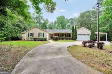
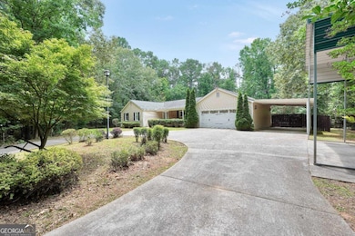
280 W Knight Rd McDonough, GA 30252
Estimated payment $3,398/month
Highlights
- Very Popular Property
- In Ground Pool
- 4.67 Acre Lot
- Union Grove High School Rated A
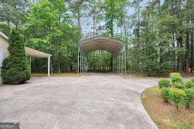
- RV or Boat Parking
- Deck
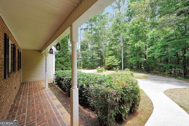
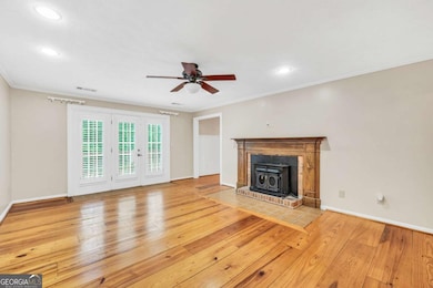
About This Home
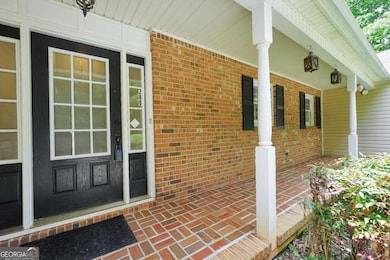
Remember the 3 P's.... Personal Private Paradise because that is exactly what this is. Welcome to this hidden gem! Sitting on nearly 5 acres, this picturesque home is a sight to behold. Sporting 5 bedrooms, 3 bathrooms, and a fully finished basement, this beauty is built to provide comfort. It offers an oversized kitchen, formal dining room, family room, and fully usable custom bar in the basement. Each of these rooms has its own exit to the backyard; the upper floor stepping out onto a house-spanning deck and the lower floor stepping out directly to the in-ground saltwater pool. And yes, you see it clearly, that is a special place to park your camper. You definitely want to come see this one!
Listing Agent
Swanson & Associates Realty Brokerage Phone: 4049140419 License #368697 Listed on: 11/05/2025
Co-Listing Agent
Swanson & Associates Realty Brokerage Phone: 4049140419 License #407689
Home Details
Home Type
- Single Family
Est. Annual Taxes
- $6,874
Year Built
- Built in 1984
Lot Details
- 4.67 Acre Lot
- Privacy Fence
- Back Yard Fenced
- Chain Link Fence
- Partially Wooded Lot
Home Design
- 2-Story Property
- Brick Exterior Construction
- Pillar, Post or Pier Foundation
- Block Foundation
- Composition Roof
- Block Exterior
- Vinyl Siding
Interior Spaces
- Family Room with Fireplace
- Formal Dining Room
- Wood Flooring
- Pull Down Stairs to Attic
- Laundry Room
Kitchen
- Microwave
- Stainless Steel Appliances
- Kitchen Island
- Solid Surface Countertops
Bedrooms and Bathrooms
- 5 Bedrooms | 3 Main Level Bedrooms
- Primary Bedroom on Main
- Double Vanity
- Soaking Tub
- Separate Shower
Finished Basement
- Basement Fills Entire Space Under The House
- Interior Basement Entry
- Finished Basement Bathroom
- Laundry in Basement
Parking
- 5 Car Garage
- Carport
- Garage Door Opener
- RV or Boat Parking
Pool
- In Ground Pool
- Saltwater Pool
Outdoor Features
- Balcony
- Deck
- Patio
- Shed
- Porch
Schools
- East Lake Elementary School
- Union Grove Middle School
- Union Grove High School
Utilities
- Forced Air Heating and Cooling System
- Electric Water Heater
- Septic Tank
- High Speed Internet
- Phone Available
- Cable TV Available
Community Details
- No Home Owners Association
Map
Home Values in the Area
Average Home Value in this Area
Tax History
| Year | Tax Paid | Tax Assessment Tax Assessment Total Assessment is a certain percentage of the fair market value that is determined by local assessors to be the total taxable value of land and additions on the property. | Land | Improvement |
|---|---|---|---|---|
| 2025 | $7,475 | $240,320 | $28,000 | $212,320 |
| 2024 | $7,475 | $209,280 | $25,200 | $184,080 |
| 2023 | $6,171 | $202,720 | $24,280 | $178,440 |
| 2022 | $5,911 | $170,280 | $22,400 | $147,880 |
| 2021 | $5,561 | $143,920 | $19,240 | $124,680 |
| 2020 | $4,058 | $116,040 | $18,120 | $97,920 |
| 2019 | $4,046 | $115,480 | $17,200 | $98,280 |
| 2018 | $3,622 | $100,440 | $15,880 | $84,560 |
| 2016 | $3,516 | $97,680 | $14,000 | $83,680 |
| 2015 | $3,786 | $102,000 | $16,120 | $85,880 |
| 2014 | $3,491 | $93,600 | $16,120 | $77,480 |
Property History
| Date | Event | Price | List to Sale | Price per Sq Ft |
|---|---|---|---|---|
| 11/05/2025 11/05/25 | For Sale | $535,000 | -- | $145 / Sq Ft |
Purchase History
| Date | Type | Sale Price | Title Company |
|---|---|---|---|
| Warranty Deed | $369,900 | -- | |
| Deed | $238,000 | -- |
Mortgage History
| Date | Status | Loan Amount | Loan Type |
|---|---|---|---|
| Open | $363,199 | FHA | |
| Previous Owner | $190,400 | New Conventional |
Source: Georgia MLS
MLS Number: 10638235
APN: 0104-01-032-000
Disclaimer: Certain information contained herein is derived from information provided by parties other than Homes.com. All information provided is deemed reliable, but is not guaranteed to be accurate and should be independently verified.
![]() The data relating to real estate for sale on this web site comes in part from the Broker Reciprocity Program of Georgia MLS. Real estate listings held by brokerage firms other than Redfin are marked with the Broker Reciprocity logo and detailed information about them includes the name of the listing brokers. Information deemed reliable but not guaranteed. Copyright 2025 Georgia MLS. All rights reserved.
The data relating to real estate for sale on this web site comes in part from the Broker Reciprocity Program of Georgia MLS. Real estate listings held by brokerage firms other than Redfin are marked with the Broker Reciprocity logo and detailed information about them includes the name of the listing brokers. Information deemed reliable but not guaranteed. Copyright 2025 Georgia MLS. All rights reserved.
- 1650 Campground Rd
- 1490 Campground Rd
- 104 Accolade Pkwy
- 112 Accolade Pkwy
- 210 Enfield Ln
- 1422 New Holland Cir
- 565 Elliott Rd
- 569 Saltbox Ln
- 557 Saltbox Ln
- 229 Overland Trail
- 598 Elliott Rd
- Nova Plan at Brush Arbor
- Addison Plan at Brush Arbor
- Evelyn Plan at Brush Arbor
- Charlotte Plan at Brush Arbor
- Aria Plan at Brush Arbor
- Camilla Plan at Brush Arbor
- Paisley Plan at Brush Arbor
- Luna Plan at Brush Arbor
- Aurora Plan at Brush Arbor
- 216 Fannin Ln
- 336 Sinclair Ct
- 35 Little Deer Trail
- 227 Bella Vista Terrace
- 226 Bella Vista Terrace
- 2480 N
- 200 Bella Vista Terrace
- 126 Bellington Dr
- 1390 Ethans Way
- 45 Gentry Dr
- 104 Bellington Dr
- 100 Agee Ln
- 100 Agee Ln Unit Wakefield
- 100 Agee Ln Unit Maxton
- 100 Agee Ln Unit Wilmont
- 117 Brookhaven Ln
- 115 Brookhaven Ln
- 113 Tyre Dr
- 7011 Regency Ln
- 6031 Ambassador Dr
