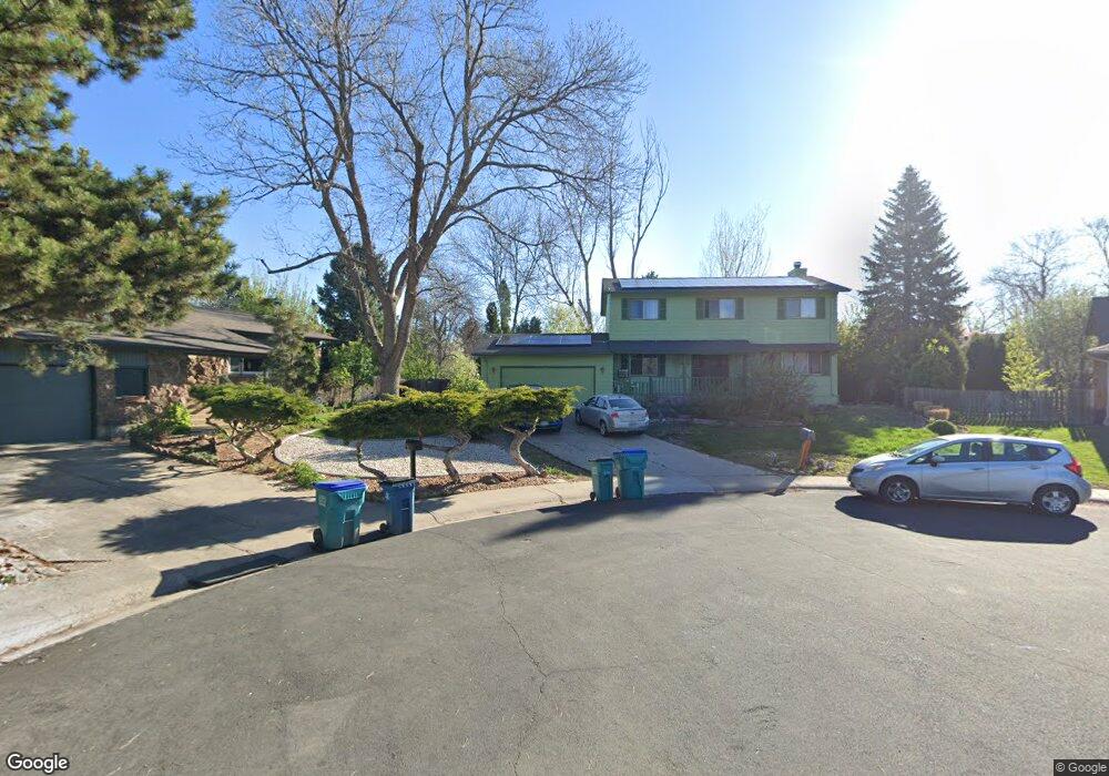
2800 Crystal Ct Fort Collins, CO 80525
Lake Sherwood NeighborhoodEstimated Value: $637,334 - $686,000
5
Beds
3
Baths
2,621
Sq Ft
$252/Sq Ft
Est. Value
About This Home
This home is located at 2800 Crystal Ct, Fort Collins, CO 80525 and is currently estimated at $661,334, approximately $252 per square foot. 2800 Crystal Ct is a home located in Larimer County with nearby schools including Shepardson Elementary School, Boltz Middle School, and Fort Collins High School.
Ownership History
Date
Name
Owned For
Owner Type
Purchase Details
Closed on
May 23, 2013
Sold by
Cain Patrick Joseph and Cain Marie Mason
Bought by
Cain Patrick Joseph
Current Estimated Value
Home Financials for this Owner
Home Financials are based on the most recent Mortgage that was taken out on this home.
Original Mortgage
$197,600
Outstanding Balance
$139,580
Interest Rate
3.41%
Mortgage Type
New Conventional
Estimated Equity
$521,754
Purchase Details
Closed on
May 17, 2002
Sold by
Jensen Karl G and Jensen Judith Ann B
Bought by
Cain Patrick Joseph and Cain Marie Mason
Home Financials for this Owner
Home Financials are based on the most recent Mortgage that was taken out on this home.
Original Mortgage
$224,200
Interest Rate
7.1%
Purchase Details
Closed on
Jul 1, 1992
Sold by
Dahl Michael H
Bought by
Jensen Karl G
Create a Home Valuation Report for This Property
The Home Valuation Report is an in-depth analysis detailing your home's value as well as a comparison with similar homes in the area
Home Values in the Area
Average Home Value in this Area
Purchase History
| Date | Buyer | Sale Price | Title Company |
|---|---|---|---|
| Cain Patrick Joseph | -- | Land Title Guarantee Company | |
| Cain Patrick Joseph | $236,000 | -- | |
| Jensen Karl G | $139,900 | -- |
Source: Public Records
Mortgage History
| Date | Status | Borrower | Loan Amount |
|---|---|---|---|
| Open | Cain Patrick Joseph | $197,600 | |
| Closed | Cain Patrick Joseph | $224,200 |
Source: Public Records
Tax History Compared to Growth
Tax History
| Year | Tax Paid | Tax Assessment Tax Assessment Total Assessment is a certain percentage of the fair market value that is determined by local assessors to be the total taxable value of land and additions on the property. | Land | Improvement |
|---|---|---|---|---|
| 2025 | $3,767 | $42,940 | $2,814 | $40,126 |
| 2024 | $3,584 | $42,940 | $2,814 | $40,126 |
| 2022 | $3,178 | $33,659 | $2,919 | $30,740 |
| 2021 | $3,212 | $34,627 | $3,003 | $31,624 |
| 2020 | $2,784 | $29,751 | $3,003 | $26,748 |
| 2019 | $2,796 | $29,751 | $3,003 | $26,748 |
| 2018 | $2,528 | $27,734 | $3,024 | $24,710 |
| 2017 | $2,519 | $27,734 | $3,024 | $24,710 |
| 2016 | $2,282 | $24,994 | $3,343 | $21,651 |
| 2015 | $2,265 | $24,990 | $3,340 | $21,650 |
| 2014 | $1,922 | $21,070 | $3,340 | $17,730 |
Source: Public Records
Map
Nearby Homes
- 2926 Brookwood Place
- 2913 Fauborough Ct
- 2830 Middlesborough Ct
- 1706 Lakeshore Dr
- 3036 Regatta Ln Unit 2
- 3031 Eastborough Dr
- 1024 E Swallow Rd Unit B214
- 1001 Strachan Dr Unit 22
- 3319 Pepperwood Ln
- 1730 Tanglewood Dr
- 2961 Sagebrush Dr
- 1337 Green Gables Ct
- 1113 Parkwood Dr
- 809 E Drake Rd Unit B112
- 1219 Mansfield Dr
- 3465 Lochwood Dr Unit S91
- 3012 Sombrero Ln
- 1724 Westchester Ln
- 3500 Rolling Green Dr Unit O53
- 2107 Kirkwood Ct
- 2801 Crystal Ct
- 2719 Granada Hills Dr
- 2713 Granada Hills Dr
- 2725 Granada Hills Dr
- 2806 Crystal Ct
- 1431 Lakeshore Dr
- 1437 Lakeshore Dr
- 2707 Granada Hills Dr
- 1425 Lakeshore Dr
- 2807 Crystal Ct
- 2900 Silverwood Dr
- 2731 Granada Hills Dr
- 1419 Lakeshore Dr
- 2701 Granada Hills Dr
- 2813 Crystal Ct
- 2718 Granada Hills Dr
- 2712 Granada Hills Dr
- 2906 Silverwood Dr
- 1413 Lakeshore Dr
- 2724 Granada Hills Dr