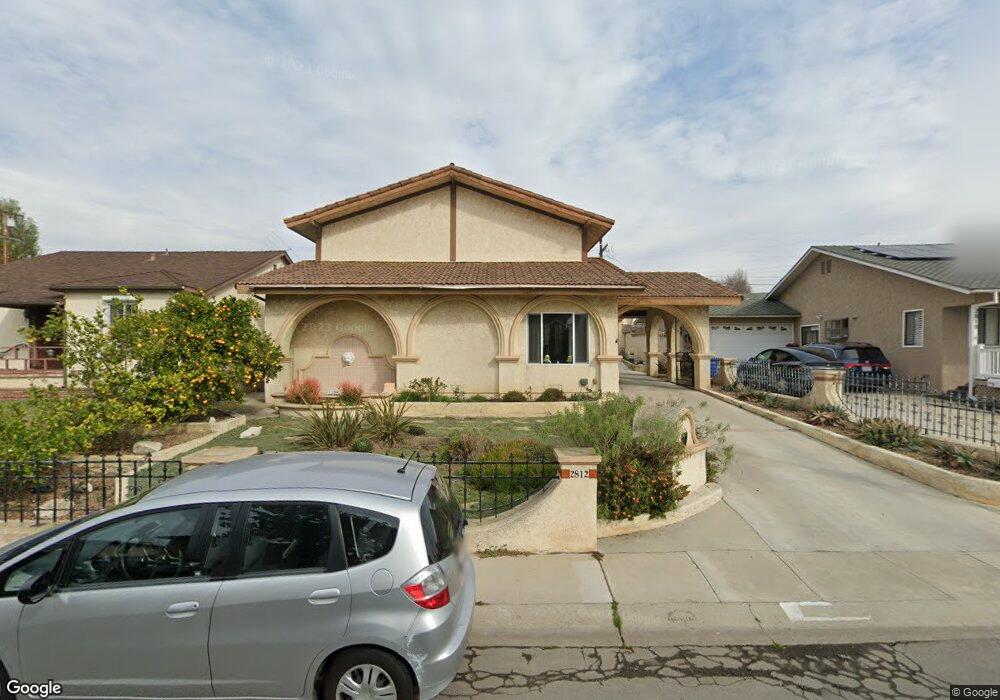
2812 May Ave Redondo Beach, CA 90278
North Redondo Beach NeighborhoodEstimated Value: $1,799,000 - $2,727,000
5
Beds
4
Baths
2,731
Sq Ft
$771/Sq Ft
Est. Value
About This Home
This home is located at 2812 May Ave, Redondo Beach, CA 90278 and is currently estimated at $2,105,263, approximately $770 per square foot. 2812 May Ave is a home located in Los Angeles County with nearby schools including Lincoln Elementary School, Adams Middle School, and Redondo Union High School.
Ownership History
Date
Name
Owned For
Owner Type
Purchase Details
Closed on
Jan 30, 2020
Sold by
Breen Robert H and Breen Elizabeth Crabb
Bought by
Breen Robert Howard and Breen Elizabeth Crabb
Current Estimated Value
Purchase Details
Closed on
Mar 13, 1996
Sold by
Vaillant Orval E
Bought by
Breen Robert H and Breen Elizabeth Crabb
Home Financials for this Owner
Home Financials are based on the most recent Mortgage that was taken out on this home.
Original Mortgage
$296,000
Interest Rate
8.03%
Create a Home Valuation Report for This Property
The Home Valuation Report is an in-depth analysis detailing your home's value as well as a comparison with similar homes in the area
Home Values in the Area
Average Home Value in this Area
Purchase History
We collect this data history from publicly available records. To have your information removed, we recommend requesting removal directly through your county’s website.
| Date | Buyer | Sale Price | Title Company |
|---|---|---|---|
| Breen Robert Howard | -- | None Available | |
| Breen Robert H | $370,000 | North American Title Co |
Source: Public Records
Mortgage History
We collect this data history from publicly available records. To have your information removed, we recommend requesting removal directly through your county’s website.
| Date | Status | Borrower | Loan Amount |
|---|---|---|---|
| Previous Owner | Breen Robert H | $296,000 | |
| Closed | Breen Robert H | $37,000 |
Source: Public Records
Tax History
| Year | Tax Paid | Tax Assessment Tax Assessment Total Assessment is a certain percentage of the fair market value that is determined by local assessors to be the total taxable value of land and additions on the property. | Land | Improvement |
|---|---|---|---|---|
| 2025 | $7,918 | $602,598 | $316,283 | $286,315 |
| 2024 | $7,557 | $590,783 | $310,082 | $280,701 |
| 2023 | $7,427 | $579,200 | $304,002 | $275,198 |
| 2022 | $7,287 | $567,844 | $298,042 | $269,802 |
| 2021 | $7,082 | $556,711 | $292,199 | $264,512 |
| 2019 | $6,905 | $540,200 | $283,533 | $256,667 |
| 2018 | $6,648 | $529,609 | $277,974 | $251,635 |
| 2016 | $6,413 | $509,045 | $267,181 | $241,864 |
| 2015 | $6,300 | $501,399 | $263,168 | $238,231 |
| 2014 | $6,213 | $491,578 | $258,013 | $233,565 |
Source: Public Records
Map
Nearby Homes
- 2812 Pinckard Ave
- 3219 Gibson Place
- 2413 Curtis Ave Unit A
- 2501 Curtis Ave
- 2500 Phelan Ln
- 2516 Gates Ave Unit B
- 2308 Curtis Ave
- 2517 Curtis Ave
- 2905 Rindge Ln
- 2601 Curtis Ave
- 2518 Curtis Ave Unit 3
- 2116 Ernest Ave Unit B
- 2219 Voorhees Ave Unit 2
- 2621 Gates Ave Unit B
- 2217 Voorhees Ave
- 2417 Ruhland Ave
- 2420 Sebald Ave
- 4755 W 166th St
- 3408 Dow Ave
- 2622 Curtis Ave
Your Personal Tour Guide
Ask me questions while you tour the home.