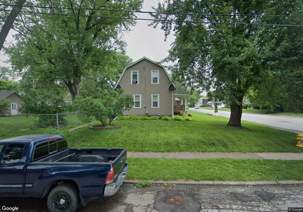
2825 E Locust St Davenport, IA 52803
East End NeighborhoodEstimated Value: $209,733 - $229,000
4
Beds
4
Baths
1,682
Sq Ft
$129/Sq Ft
Est. Value
About This Home
This home is located at 2825 E Locust St, Davenport, IA 52803 and is currently estimated at $217,683, approximately $129 per square foot. 2825 E Locust St is a home located in Scott County with nearby schools including McKinley Elementary School, Sudlow Intermediate School, and Central High School.
Ownership History
Date
Name
Owned For
Owner Type
Purchase Details
Closed on
Sep 11, 2017
Sold by
Whitham Leslie L
Bought by
Webb Joshua D and Webb Josh
Current Estimated Value
Purchase Details
Closed on
May 24, 2006
Sold by
Ridge James L and Ridge Gayle D
Bought by
Webb Josh and Whitham Leslie L
Home Financials for this Owner
Home Financials are based on the most recent Mortgage that was taken out on this home.
Original Mortgage
$114,750
Interest Rate
6.62%
Mortgage Type
FHA
Purchase Details
Closed on
Feb 24, 2005
Sold by
Ib Property Holdings Lc
Bought by
Ridge James L and Ridge Gavle
Create a Home Valuation Report for This Property
The Home Valuation Report is an in-depth analysis detailing your home's value as well as a comparison with similar homes in the area
Home Values in the Area
Average Home Value in this Area
Purchase History
| Date | Buyer | Sale Price | Title Company |
|---|---|---|---|
| Webb Joshua D | -- | None Available | |
| Webb Josh | $116,000 | None Available | |
| Ridge James L | $63,000 | None Available |
Source: Public Records
Mortgage History
| Date | Status | Borrower | Loan Amount |
|---|---|---|---|
| Previous Owner | Webb Josh | $114,750 |
Source: Public Records
Tax History Compared to Growth
Tax History
| Year | Tax Paid | Tax Assessment Tax Assessment Total Assessment is a certain percentage of the fair market value that is determined by local assessors to be the total taxable value of land and additions on the property. | Land | Improvement |
|---|---|---|---|---|
| 2025 | $3,028 | $196,440 | $22,050 | $174,390 |
| 2024 | $2,956 | $169,470 | $22,050 | $147,420 |
| 2023 | $3,694 | $169,470 | $22,050 | $147,420 |
| 2022 | $3,983 | $165,080 | $18,740 | $146,340 |
| 2021 | $3,442 | $160,430 | $18,740 | $141,690 |
| 2020 | $3,612 | $149,980 | $18,740 | $131,240 |
| 2019 | $3,400 | $140,690 | $18,740 | $121,950 |
| 2018 | $997 | $140,690 | $18,740 | $121,950 |
| 2017 | $750 | $134,880 | $18,740 | $116,140 |
| 2016 | $3,270 | $134,880 | $0 | $0 |
| 2015 | $2,764 | $130,680 | $0 | $0 |
| 2014 | $2,708 | $130,680 | $0 | $0 |
| 2013 | $2,658 | $0 | $0 | $0 |
| 2012 | -- | $128,360 | $18,840 | $109,520 |
Source: Public Records
Map
Nearby Homes
- 2950 E 18th St
- 2905 Middle Rd
- 3009 E 18th St
- 3019 E 18th St
- 49 Kenwood Ave
- 2704 E High St
- 2131 Lorton Ave
- 2234 Fairhaven Rd
- 1734 Ridgewood Ave
- 1708 Eastmere Dr
- 123 Fernwood Ave
- 1704 Jersey Ridge Rd
- 3418 Middle Rd
- 1815 Belle Ave
- 1803 Belle Ave
- 2458 E Central Park Ave
- 1360 Heights Ct
- 46 Hillcrest Ave
- 2718 Fairhaven Rd
- 102 Forest Rd
- 2819 E Locust St
- 2829 E Locust St
- 2833 E Locust St
- 2815 E Locust St
- 2839 E Locust St
- 2811 E Locust St
- 2826 E 18th St
- 2820 E 18th St
- 2830 E 18th St
- 2816 E 18th St
- 2834 E 18th St
- 2807 E Locust St
- 2843 E Locust St
- 2812 E 18th St
- 2840 E 18th St
- 2846 E Locust St
- 2836 E Locust St
- 2848 E Locust St
- 2801 E Locust St
- 2826 E Locust St