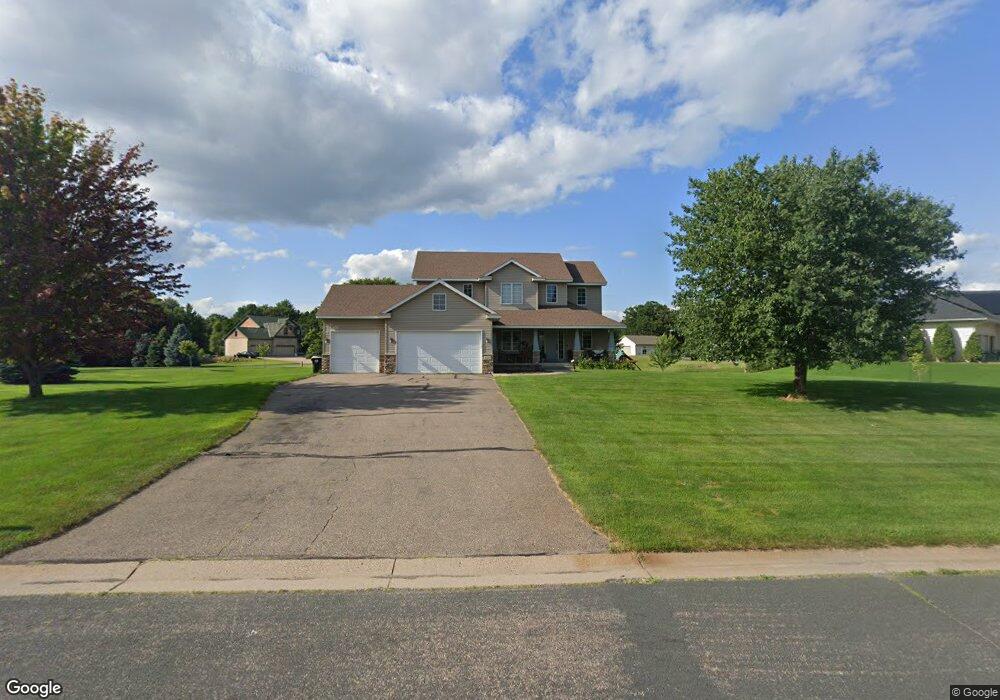
2847 180th Ave NE Andover, MN 55304
Estimated Value: $583,041 - $719,000
5
Beds
4
Baths
2,478
Sq Ft
$253/Sq Ft
Est. Value
About This Home
This home is located at 2847 180th Ave NE, Andover, MN 55304 and is currently estimated at $627,010, approximately $253 per square foot. 2847 180th Ave NE is a home located in Anoka County with nearby schools including McKinley Elementary School, Roosevelt Middle School, and Blaine Senior High School.
Ownership History
Date
Name
Owned For
Owner Type
Purchase Details
Closed on
Oct 10, 2003
Sold by
Alliance Homes Of Mn Inc
Bought by
Swenson Kendall W and Swenson Mary T
Current Estimated Value
Purchase Details
Closed on
Aug 29, 2003
Sold by
Peterson Kenneth L and Peterson Faith Hope
Bought by
Woodland Development Corp
Create a Home Valuation Report for This Property
The Home Valuation Report is an in-depth analysis detailing your home's value as well as a comparison with similar homes in the area
Home Values in the Area
Average Home Value in this Area
Purchase History
| Date | Buyer | Sale Price | Title Company |
|---|---|---|---|
| Swenson Kendall W | $420,000 | -- | |
| Alliance Homes Of Minnesota Inc | $78,900 | -- | |
| Woodland Development Corp | $2,340,000 | -- |
Source: Public Records
Mortgage History
| Date | Status | Borrower | Loan Amount |
|---|---|---|---|
| Closed | Woodland Development Corp | -- |
Source: Public Records
Tax History Compared to Growth
Tax History
| Year | Tax Paid | Tax Assessment Tax Assessment Total Assessment is a certain percentage of the fair market value that is determined by local assessors to be the total taxable value of land and additions on the property. | Land | Improvement |
|---|---|---|---|---|
| 2025 | $4,529 | $535,400 | $139,000 | $396,400 |
| 2024 | $4,529 | $515,100 | $130,700 | $384,400 |
| 2023 | $4,346 | $528,100 | $123,500 | $404,600 |
| 2022 | $3,719 | $521,600 | $108,100 | $413,500 |
| 2021 | $3,503 | $392,800 | $84,600 | $308,200 |
| 2020 | $7,019 | $364,400 | $79,000 | $285,400 |
| 2019 | $3,573 | $346,100 | $79,000 | $267,100 |
| 2018 | $3,538 | $346,000 | $0 | $0 |
| 2017 | $3,281 | $329,300 | $0 | $0 |
| 2016 | $3,506 | $314,800 | $0 | $0 |
| 2015 | -- | $314,800 | $76,700 | $238,100 |
| 2014 | -- | $265,700 | $57,500 | $208,200 |
Source: Public Records
Map
Nearby Homes
- TBD S 179th Ave NE
- 17742 Oakland Dr NE
- 2475 179th Ave NE
- 18216 Yancy St NE
- 18019 Urbank St NE
- xxx 179th Ln NE
- 18022 Urbank St NE
- 18056 Urbank St NE
- L4 B3 180th Ln NE
- xxx Taconite St NE
- 17973 Taconite St NE
- 18071 Urbank St NE
- 2374 Swedish Dr NE
- 2728 174th Ave NE
- 17982 Staples St NE
- 3413 Interlachen Dr NE
- 2349 175th Ln NE
- 3461 Interlachen Dr NE
- 2336 Swedish Dr NE
- 17307 Hiawatha Beach Dr NE
- 2861 180th Ave NE
- 18009 Coral Sea St NE
- 2844 180th Ave NE
- 17958 Coral Sea St NE
- 2862 180th Ave NE
- 2911 180th Ave NE
- 18012 Coral Sea St NE
- 17934 Coral Sea St NE
- 2908 180th Ave NE
- 18015 Coral Sea St NE
- 18021 Coral Sea St NE
- 17918 Coral Sea St NE
- 2834 179th Ave NE
- 2759 179th Ave NE
- 2852 179th Ave NE
- 17855 Oakland Dr NE
- 0 Oakland Dr NE
- 2458 179th Ave NE
- 17838 Oakland Dr NE
- 17822 Oakland Dr NE