K
Seller's Agent in 2025
Kim Leis Anderson
Leis Realty Company
(937) 417-3923
70 Total Sales
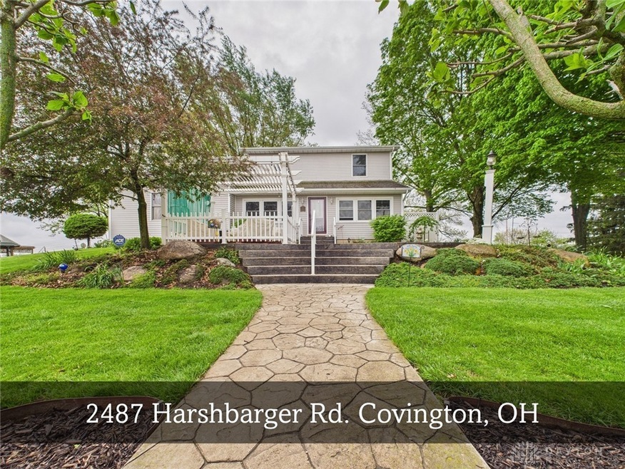
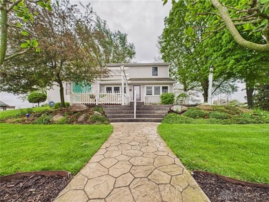
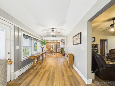

Nestled atop a gentle hill along a quiet, private country road, this beautifully maintained two-story home offers 2,750 square feet of living space with five bedrooms and two full bathrooms. Set on two scenic acres with lush landscaping and vibrant garden areas, this property is a true rural sanctuary. As you walkup to the home you will be welcomed with a patio area and a covered pergola to enjoy your morning coffee or evening ice tea.
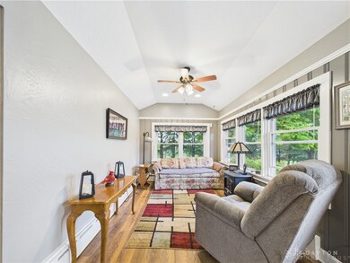
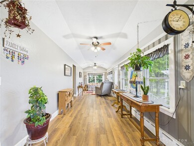
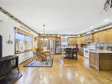
Inside, the home features a sitting area to enjoy the country view and is open into the large kitchen with spacious countertop, cabinets, dishwasher and refrigerator 2024, and 2 ovens in 2022 and room the the family and friends to gather. You will enjoy a beautiful view of the country from the dining area. The layout with a main-level primary bedroom and a full bath for added convenience. Upstairs, you’ll find three additional bedrooms, ample storage space, and a fully remodeled full bathroom, showcasing modern finishes while retaining cozy, country charm. A fifth bedroom adds flexibility for guests, a home office, or hobby space. The home is in excellent condition throughout, reflecting pride of ownership. The home offers a variety of heat options, with one being an outside wood stove for the hot water steam heat.
Outside, the property is fully equipped for a variety of uses. A detached 24x26 garage offers secure parking and extra storage, while a sturdy 40x60 barn, a 46x16 poultry house or garden house, and an 8x12 utility shed provide ample space for animals, tools, or equipment. A 7x18 framed shelter adds even more versatility for enjoying outside relaxation. The grounds are thoughtfully landscaped with well-tended gardens and open green space, perfect for enjoying peaceful countryside living.
This is a rare opportunity to own a spacious, move-in-ready home with multiple outbuildings in a serene, private rural setting—ideal for homesteaders, hobby farmers, or anyone seeking a quiet escape with room to grow.
Last Agent to Sell the Property
Leis Realty Company Brokerage Phone: (937) 548-5750 Listed on: 05/08/2025
| Date | Type | Sale Price | Title Company |
|---|---|---|---|
| Deed | $440,250 | None Listed On Document | |
| Warranty Deed | $215,000 | -- | |
| Warranty Deed | $215,000 | -- | |
| Deed | $87,700 | -- |
| Date | Status | Loan Amount | Loan Type |
|---|---|---|---|
| Open | $396,000 | New Conventional | |
| Previous Owner | $130,000 | New Conventional | |
| Previous Owner | $130,000 | New Conventional | |
| Closed | -- | New Conventional |
| Date | Event | Price | List to Sale | Price per Sq Ft |
|---|---|---|---|---|
| 06/26/2025 06/26/25 | Sold | $440,000 | +2.6% | $160 / Sq Ft |
| 06/14/2025 06/14/25 | Pending | -- | -- | -- |
| 05/12/2025 05/12/25 | For Sale | $428,750 | 0.0% | $156 / Sq Ft |
| 05/11/2025 05/11/25 | Pending | -- | -- | -- |
| 05/08/2025 05/08/25 | For Sale | $428,750 | -- | $156 / Sq Ft |
| Year | Tax Paid | Tax Assessment Tax Assessment Total Assessment is a certain percentage of the fair market value that is determined by local assessors to be the total taxable value of land and additions on the property. | Land | Improvement |
|---|---|---|---|---|
| 2024 | $3,802 | $112,460 | $11,800 | $100,660 |
| 2023 | $3,431 | $112,460 | $11,800 | $100,660 |
| 2022 | $4,214 | $112,460 | $11,800 | $100,660 |
| 2021 | $3,755 | $93,740 | $9,840 | $83,900 |
| 2020 | $3,765 | $93,740 | $9,840 | $83,900 |
| 2019 | $3,521 | $93,740 | $9,840 | $83,900 |
| 2018 | $2,643 | $70,640 | $9,700 | $60,940 |
| 2017 | $2,667 | $70,640 | $9,700 | $60,940 |
| 2016 | $2,633 | $70,640 | $9,700 | $60,940 |
| 2015 | $2,780 | $67,900 | $9,310 | $58,590 |
| 2014 | $2,780 | $67,900 | $9,310 | $58,590 |
| 2013 | $2,808 | $67,900 | $9,310 | $58,590 |
K
Seller's Agent in 2025
Kim Leis Anderson
Leis Realty Company
(937) 417-3923
70 Total Sales

Buyer's Agent in 2025
David Besecker
Keller Williams Home Town Rlty
(937) 216-2286
117 Total Sales
Source: Dayton REALTORS®
MLS Number: 933291
APN: I20028000
Disclaimer: Certain information contained herein is derived from information provided by parties other than Homes.com. All information provided is deemed reliable, but is not guaranteed to be accurate and should be independently verified.
![]() The information is being provided by Dayton Area Board of Realtors MLS. Information deemed reliable but not guaranteed. Information is provided for the consumer's personal, non-commercial use, and may not be used for any purpose other than the identification of potential properties for purchase. Copyright 2026 Dayton Area Board of Realtors MLS. All Rights Reserved.
The information is being provided by Dayton Area Board of Realtors MLS. Information deemed reliable but not guaranteed. Information is provided for the consumer's personal, non-commercial use, and may not be used for any purpose other than the identification of potential properties for purchase. Copyright 2026 Dayton Area Board of Realtors MLS. All Rights Reserved.
Ask me questions while you tour the home.