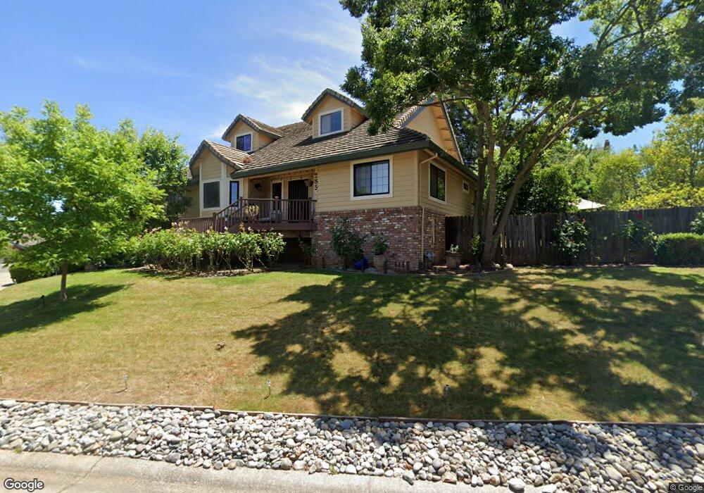
285 Spencer St Folsom, CA 95630
Estimated Value: $700,000 - $825,000
3
Beds
3
Baths
2,419
Sq Ft
$318/Sq Ft
Est. Value
About This Home
This home is located at 285 Spencer St, Folsom, CA 95630 and is currently estimated at $768,963, approximately $317 per square foot. 285 Spencer St is a home located in Sacramento County with nearby schools including Blanche Sprentz Elementary School, Sutter Middle School, and St. John Notre Dame.
Ownership History
Date
Name
Owned For
Owner Type
Purchase Details
Closed on
Dec 27, 2002
Sold by
Cartwright Kirk and Martha J Cole Revocable Trust
Bought by
Mendoza David A
Current Estimated Value
Home Financials for this Owner
Home Financials are based on the most recent Mortgage that was taken out on this home.
Original Mortgage
$281,600
Outstanding Balance
$118,732
Interest Rate
5.86%
Estimated Equity
$650,231
Purchase Details
Closed on
Feb 7, 1994
Sold by
Cole Martha J
Bought by
Cole Martha J and Martha J Cole Revocable Trust
Create a Home Valuation Report for This Property
The Home Valuation Report is an in-depth analysis detailing your home's value as well as a comparison with similar homes in the area
Purchase History
| Date | Buyer | Sale Price | Title Company |
|---|---|---|---|
| Mendoza David A | $352,000 | North American Title Company | |
| Cole Martha J | -- | -- |
Source: Public Records
Mortgage History
| Date | Status | Borrower | Loan Amount |
|---|---|---|---|
| Open | Mendoza David A | $281,600 | |
| Closed | Mendoza David A | $52,800 |
Source: Public Records
Tax History
| Year | Tax Paid | Tax Assessment Tax Assessment Total Assessment is a certain percentage of the fair market value that is determined by local assessors to be the total taxable value of land and additions on the property. | Land | Improvement |
|---|---|---|---|---|
| 2025 | $5,446 | $509,789 | $123,095 | $386,694 |
| 2024 | $5,446 | $499,794 | $120,682 | $379,112 |
| 2023 | $5,349 | $489,995 | $118,316 | $371,679 |
| 2022 | $5,271 | $480,389 | $115,997 | $364,392 |
| 2021 | $5,201 | $470,971 | $113,723 | $357,248 |
| 2020 | $5,137 | $466,142 | $112,557 | $353,585 |
| 2019 | $5,052 | $457,002 | $110,350 | $346,652 |
| 2018 | $4,926 | $448,042 | $108,187 | $339,855 |
| 2017 | $4,521 | $439,258 | $106,066 | $333,192 |
| 2016 | $4,722 | $430,646 | $103,987 | $326,659 |
| 2015 | $4,563 | $424,179 | $102,426 | $321,753 |
| 2014 | $4,330 | $415,871 | $100,420 | $315,451 |
Source: Public Records
Map
Nearby Homes
- 113 Pradera Ct
- 260 Flower Dr
- 164 Rebecca Way
- 409 Wales Dr
- 110 Fargo Way
- 115 Winchester Ct
- 98-98 1/2 Dean Way
- 510 Stafford St
- 100 Briarcliff Ct
- 167 Price Way
- 617 Wales Dr
- 182 Price Way
- 860 School St
- 219 Needles Way
- 293 Leidesdorff St
- 119 Del Norte Vista Way
- 408 Sutter St
- 603 Figueroa St
- 1121 Elderberry Cir
- 611 Mormon St
- 279 Spencer St
- 330 Cimmaron Cir
- 339 Cimmaron Cir
- 278 Spencer St
- 333 Cimmaron Cir
- 284 Spencer St
- 273 Spencer St
- 206 Saddle Ct
- 345 Cimmaron Cir
- 272 Spencer St
- 327 Cimmaron Cir
- 266 Spencer St
- 267 Spencer St
- 351 Cimmaron Cir
- 212 Saddle Ct
- 302 Cimmaron Cir
- 321 Cimmaron Cir
- 260 Spencer St
- 207 Saddle Ct
- 261 Spencer St