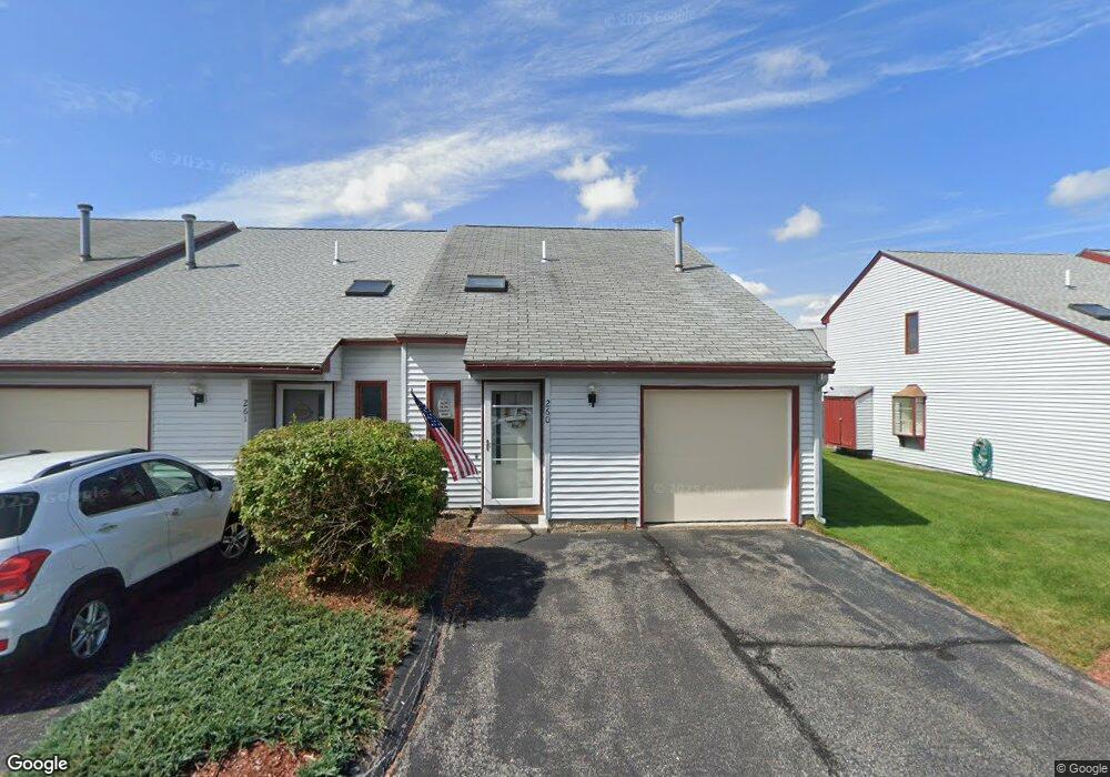
286 Stonebridge Dr Nashua, NH 03063
Northwest Nashua NeighborhoodEstimated Value: $256,000 - $311,933
2
Beds
1
Bath
1,072
Sq Ft
$271/Sq Ft
Est. Value
About This Home
This home is located at 286 Stonebridge Dr, Nashua, NH 03063 and is currently estimated at $290,233, approximately $270 per square foot. 286 Stonebridge Dr is a home located in Hillsborough County with nearby schools including Birch Hill Elementary School, Pennichuck Middle School, and Nashua High School North.
Ownership History
Date
Name
Owned For
Owner Type
Purchase Details
Closed on
Sep 2, 2015
Sold by
Whitestone Realty Asso
Bought by
Boal Mihir D and Boal Uttara M
Current Estimated Value
Purchase Details
Closed on
Aug 26, 1997
Sold by
Desrosiers Michelle R
Bought by
Boal Mihir D and Boal Uttara M
Home Financials for this Owner
Home Financials are based on the most recent Mortgage that was taken out on this home.
Original Mortgage
$21,750
Interest Rate
7.42%
Create a Home Valuation Report for This Property
The Home Valuation Report is an in-depth analysis detailing your home's value as well as a comparison with similar homes in the area
Home Values in the Area
Average Home Value in this Area
Purchase History
| Date | Buyer | Sale Price | Title Company |
|---|---|---|---|
| Boal Mihir D | $57,266 | -- | |
| Boal Mihir D | $29,000 | -- |
Source: Public Records
Mortgage History
| Date | Status | Borrower | Loan Amount |
|---|---|---|---|
| Previous Owner | Boal Mihir D | $21,750 |
Source: Public Records
Tax History Compared to Growth
Tax History
| Year | Tax Paid | Tax Assessment Tax Assessment Total Assessment is a certain percentage of the fair market value that is determined by local assessors to be the total taxable value of land and additions on the property. | Land | Improvement |
|---|---|---|---|---|
| 2023 | $3,604 | $197,700 | $0 | $197,700 |
| 2022 | $3,572 | $197,700 | $0 | $197,700 |
| 2021 | $3,406 | $146,700 | $0 | $146,700 |
| 2020 | $3,405 | $150,600 | $0 | $150,600 |
| 2019 | $3,277 | $150,600 | $0 | $150,600 |
| 2018 | $3,194 | $150,600 | $0 | $150,600 |
| 2017 | $2,700 | $104,700 | $0 | $104,700 |
| 2016 | $2,625 | $104,700 | $0 | $104,700 |
| 2015 | $1,710 | $69,700 | $0 | $69,700 |
| 2014 | $1,676 | $69,700 | $0 | $69,700 |
Source: Public Records
Map
Nearby Homes
- 2 Roedean Dr Unit Building A, Unit 106
- 2 Roedean Dr Unit UA304
- 3 Roedean Dr Unit UC103
- 3 New Haven Dr Unit UG206
- 5 Dumaine Ave Unit B
- 5 Dumaine Ave Unit C
- 7 Deerwood Dr Unit A
- 4 Candia St
- 9 Westerdale Dr
- 613 Amherst St
- 19 Bangor St
- 24 Heathrow Ct Unit U439
- 6 Lochmere Ln Unit U367
- 78 Lochmere Ln Unit U415
- 164 Tinker Rd
- 17 May Dr
- 1 Ingham Rd
- 199 Cannongate III
- 191 Cannongate III
- 9 Seaverns Bridge Rd
- 286 Stonebridge Dr
- 287 Stonebridge Dr
- 287 Stonebridge Dr
- 288 Stonebridge Dr
- 288 Stonebridge Dr
- 285 Stonebridge Dr
- 285 Stonebridge Dr Unit 285
- 284 Stonebridge Dr
- 284 Stonebridge Dr
- 284 Stonebridge Dr Unit 284
- 289 Stonebridge Dr
- 289 Stonebridge Dr
- 283 Stonebridge Dr Unit 283
- 283 Stonebridge Dr
- 283 Stonebridge Dr
- 290 Stonebridge Dr
- 290 Stonebridge Dr
- 290 Stonebridge Dr Unit 290
- 282 Stonebridge Dr
- 282 Stonebridge Dr