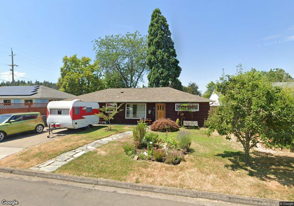
2870 High St Eugene, OR 97405
Amazon NeighborhoodEstimated Value: $313,000 - $395,000
2
Beds
1
Bath
762
Sq Ft
$476/Sq Ft
Est. Value
About This Home
This home is located at 2870 High St, Eugene, OR 97405 and is currently estimated at $362,501, approximately $475 per square foot. 2870 High St is a home located in Lane County with nearby schools including Adams Elementary School, Roosevelt Middle School, and South Eugene High School.
Ownership History
Date
Name
Owned For
Owner Type
Purchase Details
Closed on
Jun 26, 2009
Sold by
Defeo Mary Sue
Bought by
Defeo Mary Sue and Derois Kevin R
Current Estimated Value
Home Financials for this Owner
Home Financials are based on the most recent Mortgage that was taken out on this home.
Original Mortgage
$95,000
Interest Rate
4.79%
Mortgage Type
New Conventional
Purchase Details
Closed on
Jun 24, 1999
Sold by
Ann Platt Melody
Bought by
Defeo Mary Sue
Home Financials for this Owner
Home Financials are based on the most recent Mortgage that was taken out on this home.
Original Mortgage
$102,147
Interest Rate
7.05%
Mortgage Type
FHA
Create a Home Valuation Report for This Property
The Home Valuation Report is an in-depth analysis detailing your home's value as well as a comparison with similar homes in the area
Home Values in the Area
Average Home Value in this Area
Purchase History
| Date | Buyer | Sale Price | Title Company |
|---|---|---|---|
| Defeo Mary Sue | -- | Evergreen Land Title Co | |
| Defeo Mary Sue | $103,000 | Key Title Company |
Source: Public Records
Mortgage History
| Date | Status | Borrower | Loan Amount |
|---|---|---|---|
| Closed | Defeo Mary Sue | $95,000 | |
| Closed | Defeo Mary Sue | $102,147 |
Source: Public Records
Tax History
| Year | Tax Paid | Tax Assessment Tax Assessment Total Assessment is a certain percentage of the fair market value that is determined by local assessors to be the total taxable value of land and additions on the property. | Land | Improvement |
|---|---|---|---|---|
| 2025 | $3,004 | $154,164 | -- | -- |
| 2024 | $2,966 | $149,674 | -- | -- |
| 2023 | $2,966 | $145,315 | $0 | $0 |
| 2022 | $2,779 | $141,083 | $0 | $0 |
| 2021 | $2,610 | $136,974 | $0 | $0 |
| 2020 | $2,619 | $132,985 | $0 | $0 |
| 2019 | $2,530 | $129,112 | $0 | $0 |
| 2018 | $2,381 | $121,701 | $0 | $0 |
| 2017 | $2,275 | $121,701 | $0 | $0 |
| 2016 | $2,218 | $118,156 | $0 | $0 |
| 2015 | $2,154 | $114,715 | $0 | $0 |
| 2014 | $2,111 | $111,374 | $0 | $0 |
Source: Public Records
Map
Nearby Homes
- 310 1/2 E 31st Ave Unit 1
- 3023 Hummingbird Ln
- 3031 Hummingbird Ln
- 84 W 27th Ave
- 2815 Hilyard St
- 2965 Olive St
- 2683 Alder St
- 2571 Alder St
- 790 E 32nd Ave
- 180 W 23rd Ave
- 2223 Olive St
- 555 Stafford Ct
- 940 E 23rd Ave
- 585 E 36th Ave
- 2121 Hilyard St
- 75 W 35th Place
- 193 E 20th Ave
- 177 E 20th Ave
- 2031 Olive St
- 181 Civic Dr
Your Personal Tour Guide
Ask me questions while you tour the home.