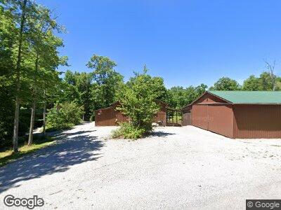
289 Briar Point Rd Allardt, TN 38504
Estimated Value: $467,377 - $521,000
--
Bed
2
Baths
1,080
Sq Ft
$456/Sq Ft
Est. Value
About This Home
This home is located at 289 Briar Point Rd, Allardt, TN 38504 and is currently estimated at $492,459, approximately $455 per square foot. 289 Briar Point Rd is a home located in Fentress County.
Ownership History
Date
Name
Owned For
Owner Type
Purchase Details
Closed on
Jul 19, 2017
Sold by
Mahon Michael Robert and Mahon Sara Jane
Bought by
Mahon Michael Robert and Mahan Sarah Jane
Current Estimated Value
Home Financials for this Owner
Home Financials are based on the most recent Mortgage that was taken out on this home.
Original Mortgage
$240,000
Interest Rate
3.88%
Mortgage Type
VA
Purchase Details
Closed on
Sep 19, 2012
Sold by
Mahon Michael Robert
Bought by
Mahon Michael Robert and Mahon Sarah Jane
Purchase Details
Closed on
Sep 3, 2010
Sold by
Nicholson Kathy
Bought by
Mahon Michael Robert
Home Financials for this Owner
Home Financials are based on the most recent Mortgage that was taken out on this home.
Original Mortgage
$140,000
Interest Rate
4.59%
Mortgage Type
New Conventional
Purchase Details
Closed on
Aug 13, 2007
Bought by
Mahon Robert Michael and Mahon Sarah Jane
Home Financials for this Owner
Home Financials are based on the most recent Mortgage that was taken out on this home.
Original Mortgage
$136,000
Interest Rate
6.65%
Mortgage Type
Cash
Create a Home Valuation Report for This Property
The Home Valuation Report is an in-depth analysis detailing your home's value as well as a comparison with similar homes in the area
Home Values in the Area
Average Home Value in this Area
Purchase History
| Date | Buyer | Sale Price | Title Company |
|---|---|---|---|
| Mahon Michael Robert | -- | None Available | |
| Mahon Michael Robert | -- | -- | |
| Mahon Michael Robert | $40,000 | -- | |
| Mahon Robert Michael | $140,000 | -- |
Source: Public Records
Mortgage History
| Date | Status | Borrower | Loan Amount |
|---|---|---|---|
| Open | Mahon Michael Robert | $194,913 | |
| Closed | Mahon Michael Robert | $210,019 | |
| Closed | Mahon Michael Robert | $240,000 | |
| Previous Owner | Mahon Michael Robert | $140,000 | |
| Previous Owner | Mahon Robert Michael | $136,000 |
Source: Public Records
Tax History Compared to Growth
Tax History
| Year | Tax Paid | Tax Assessment Tax Assessment Total Assessment is a certain percentage of the fair market value that is determined by local assessors to be the total taxable value of land and additions on the property. | Land | Improvement |
|---|---|---|---|---|
| 2024 | $1,371 | $101,550 | $23,575 | $77,975 |
| 2023 | $1,371 | $101,550 | $23,575 | $77,975 |
| 2022 | $1,245 | $65,175 | $19,225 | $45,950 |
| 2021 | $1,245 | $65,175 | $19,225 | $45,950 |
| 2020 | $1,245 | $65,175 | $19,225 | $45,950 |
| 2019 | $1,245 | $65,175 | $19,225 | $45,950 |
| 2018 | $1,245 | $65,175 | $19,225 | $45,950 |
| 2017 | $1,045 | $52,675 | $15,950 | $36,725 |
| 2016 | $1,045 | $52,675 | $15,950 | $36,725 |
| 2015 | $1,045 | $52,676 | $0 | $0 |
| 2014 | $1,045 | $52,676 | $0 | $0 |
Source: Public Records
Map
Nearby Homes
- 20 Bluff View Loop
- 145 Horse Haven Rd
- 0 Coyote Trail
- 1032 Range Cemetery Rd
- 50 acres Oloff Smith Rd
- 1070 Chestnut Ridge Rd
- lot 17 Long Ridge Way
- 0 Sam Smith Rd Unit RTC2865905
- 0 Sam Smith Rd Unit 236295
- 0 72 Acres Cole Place Rd
- 21.31 Cole Place Rd
- 3540 Stockton Rd
- 499 Stockton Chapel Rd
- 15.31 AC Rugby Pike
- Lot 24 Old Mount Helen Rd
- Lot 23 Old Mount Helen Rd
- Lot 19 Old Mount Helen Rd
- Lot 13 Old Mount Helen Rd
- 0 Old Mount Helen Rd
- 182 Stockton Chapel Rd
