Estimated Value: $1,142,000 - $2,703,797
6
Beds
2
Baths
3,555
Sq Ft
$471/Sq Ft
Est. Value
About This Home
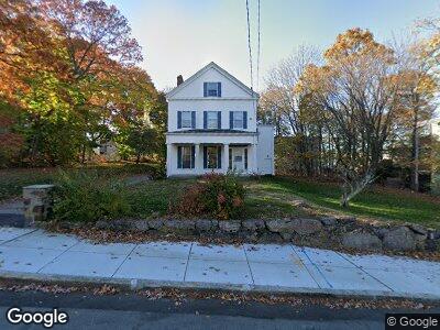
This home is located at 29 High St, Dorchester, MA 02122 and is currently estimated at $1,675,949, approximately $471 per square foot. 29 High St is a home with nearby schools including Helen Y. Davis Leadership Academy Charter Public School, Pope John Paul II Catholic Academy Columbia Campus, and Cristo Rey Boston High School.
Ownership History
Date
Name
Owned For
Owner Type
Purchase Details
Closed on
Jul 19, 2018
Sold by
First Parish Church Do
Bought by
29 High Street Doc Llc
Current Estimated Value
Home Financials for this Owner
Home Financials are based on the most recent Mortgage that was taken out on this home.
Original Mortgage
$1,312,500
Interest Rate
4.5%
Mortgage Type
Commercial
Create a Home Valuation Report for This Property
The Home Valuation Report is an in-depth analysis detailing your home's value as well as a comparison with similar homes in the area
Home Values in the Area
Average Home Value in this Area
Purchase History
| Date | Buyer | Sale Price | Title Company |
|---|---|---|---|
| 29 High Street Doc Llc | $1,750,000 | -- |
Source: Public Records
Mortgage History
| Date | Status | Borrower | Loan Amount |
|---|---|---|---|
| Open | 29 High Street Dot Llc | $2,000,000 | |
| Closed | 29 High Street Doc Llc | $1,312,500 |
Source: Public Records
Tax History Compared to Growth
Tax History
| Year | Tax Paid | Tax Assessment Tax Assessment Total Assessment is a certain percentage of the fair market value that is determined by local assessors to be the total taxable value of land and additions on the property. | Land | Improvement |
|---|---|---|---|---|
| 2025 | $4,585 | $395,900 | $375,300 | $20,600 |
| 2024 | $3,878 | $355,800 | $335,200 | $20,600 |
| 2023 | $12,302 | $1,145,400 | $508,800 | $636,600 |
| 2022 | $11,329 | $1,041,300 | $462,600 | $578,700 |
| 2021 | $10,287 | $964,100 | $428,300 | $535,800 |
| 2020 | $8,920 | $844,700 | $406,200 | $438,500 |
| 2019 | $0 | $972,800 | $631,700 | $341,100 |
| 2018 | $0 | $945,200 | $609,900 | $335,300 |
| 2017 | $0 | $905,200 | $585,800 | $319,400 |
| 2016 | -- | $816,900 | $542,200 | $274,700 |
| 2015 | -- | $712,500 | $474,900 | $237,600 |
| 2014 | -- | $665,500 | $431,000 | $234,500 |
Source: Public Records
Map
Nearby Homes
- 22 High St Unit 103
- 22 High St Unit PH13
- 22 High St Unit 102
- 22 High St Unit 203
- 28 Fifield St Unit 1
- 28 Fifield St
- 24 Fifield St
- 67 Church St Unit 3
- 148 Pleasant St
- 33 Adams St Unit 2
- 2 Howe Terrace Unit 18
- 3 Coleman St
- 18 Lyon St Unit 2
- 18 Lyon St Unit 1
- 26 Potosi St
- 12-14 Deer St Unit 2
- 12-14 Deer St Unit 1
- 12-14 Deer St Unit 3
- 40 Linden St Unit C
- 39 Juliette St Unit 3
- 29 High St
- 29 High St Unit 1
- 29 High St
- 35 High St
- 19 High St
- 17 High St
- 11 Navillus Terrace
- 11 Navillus Terrace Unit 2
- 22 High St
- 22 High St Unit PH12
- 28 High St
- 9 Navillus Terrace Unit 3
- 9 Navillus Terrace
- 9 Navillus Terrace Unit 1
- 9 Navillus Terrace Unit 2
- 40 Church St
- 40 Church St Unit 2
- 38 Church St
- 24 Winter St
- 24 Winter St Unit 1