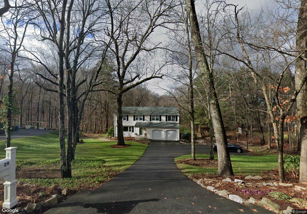
29 Stanley Dr Glastonbury, CT 06033
East Glastonbury NeighborhoodEstimated Value: $624,000 - $677,000
3
Beds
4
Baths
2,176
Sq Ft
$297/Sq Ft
Est. Value
About This Home
This home is located at 29 Stanley Dr, Glastonbury, CT 06033 and is currently estimated at $646,630, approximately $297 per square foot. 29 Stanley Dr is a home located in Hartford County with nearby schools including Eastbury School, Gideon Welles School, and Smith Middle School.
Ownership History
Date
Name
Owned For
Owner Type
Purchase Details
Closed on
May 6, 2025
Sold by
Morris Michael F and Morris Jane D
Bought by
Morris Flt and Morris M
Current Estimated Value
Purchase Details
Closed on
Apr 24, 1997
Sold by
Wright Richard S and Wright Judith H
Bought by
Morris Michael F and Morris Jane D
Purchase Details
Closed on
Aug 2, 1994
Sold by
Wright Richard S and Wright Judith H
Bought by
Morris Michael F and Morris Jane D
Purchase Details
Closed on
Aug 11, 1987
Sold by
Collins Alec G
Bought by
Wright Richard S
Create a Home Valuation Report for This Property
The Home Valuation Report is an in-depth analysis detailing your home's value as well as a comparison with similar homes in the area
Home Values in the Area
Average Home Value in this Area
Purchase History
| Date | Buyer | Sale Price | Title Company |
|---|---|---|---|
| Morris Flt | -- | None Available | |
| Morris Flt | -- | None Available | |
| Morris Michael F | $212,500 | -- | |
| Morris Michael F | $212,500 | -- | |
| Morris Michael F | $212,500 | -- | |
| Morris Michael F | $212,500 | -- | |
| Wright Richard S | $239,000 | -- |
Source: Public Records
Mortgage History
| Date | Status | Borrower | Loan Amount |
|---|---|---|---|
| Previous Owner | Wright Richard S | $150,000 | |
| Previous Owner | Wright Richard S | $195,000 | |
| Previous Owner | Wright Richard S | $178,000 |
Source: Public Records
Tax History Compared to Growth
Tax History
| Year | Tax Paid | Tax Assessment Tax Assessment Total Assessment is a certain percentage of the fair market value that is determined by local assessors to be the total taxable value of land and additions on the property. | Land | Improvement |
|---|---|---|---|---|
| 2025 | $10,630 | $323,800 | $126,400 | $197,400 |
| 2024 | $10,339 | $323,800 | $126,400 | $197,400 |
| 2023 | $10,041 | $323,800 | $126,400 | $197,400 |
| 2022 | $9,332 | $250,200 | $104,900 | $145,300 |
| 2021 | $9,337 | $250,200 | $104,900 | $145,300 |
| 2020 | $9,232 | $250,200 | $104,900 | $145,300 |
| 2019 | $9,097 | $250,200 | $104,900 | $145,300 |
| 2018 | $9,007 | $250,200 | $104,900 | $145,300 |
| 2017 | $8,902 | $237,700 | $104,900 | $132,800 |
| 2016 | $8,652 | $237,700 | $104,900 | $132,800 |
| 2015 | $8,581 | $237,700 | $104,900 | $132,800 |
| 2014 | $8,474 | $237,700 | $104,900 | $132,800 |
Source: Public Records
Map
Nearby Homes
- 36 Sand Hill Ln
- 49 Millstone Rd
- 160 Pond Cir
- 0 Hebron Ave
- 297 Wickham Rd
- 47 Brookview Dr
- 509 Cedar Ridge Dr
- 97 Crosby Rd
- 96 Crosby Rd
- 474 Neipsic Rd
- 85 Oxbow Dr Unit C7
- 105 (Option A) Crosby Rd
- 105 (Option B) Crosby Rd
- 38 Rambling Brook Ln Unit A2
- 1925 Manchester Rd
- 60 Saddle Ridge Rd
- 92 Ash Swamp Rd
- 76 Trymbulak Ln
- 319 Great Swamp Rd
- 366 Woodhaven Rd
- 39 Stanley Dr
- 13 Stanley Dr
- 36 Stanley Dr
- 49 Stanley Dr
- 1794 Chalker Hill
- 1838 Chalker Hill
- 57 Stanley Dr
- 66 Stanley Dr
- 1852 Chalker Hill
- 1786 Chalker Hill
- 68 Stanley Dr
- 1858 Chalker Hill
- 67 Stanley Dr
- 78 Stanley Dr
- 1776 Chalker Hill
- 25 Colony Cir
- 1862 Chalker Hill
- 83 Stanley Dr
- 88 Stanley Dr
- 22 Colony Cir