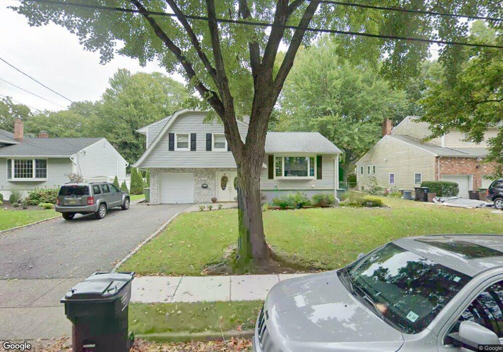
290 Mchenry Dr Paramus, NJ 07652
Estimated Value: $937,688 - $1,100,000
Studio
--
Bath
1,888
Sq Ft
$537/Sq Ft
Est. Value
About This Home
This home is located at 290 Mchenry Dr, Paramus, NJ 07652 and is currently estimated at $1,013,922, approximately $537 per square foot. 290 Mchenry Dr is a home located in Bergen County with nearby schools including Paramus High School, David Gregory School, and Visitation Academy.
Ownership History
Date
Name
Owned For
Owner Type
Purchase Details
Closed on
Jan 30, 2007
Sold by
Peros Zlatica
Bought by
Peros Margaret
Current Estimated Value
Purchase Details
Closed on
Apr 3, 2000
Sold by
Hershaff Stuart
Bought by
Peros Margaret and Peros Ante
Home Financials for this Owner
Home Financials are based on the most recent Mortgage that was taken out on this home.
Original Mortgage
$208,000
Interest Rate
8.3%
Create a Home Valuation Report for This Property
The Home Valuation Report is an in-depth analysis detailing your home's value as well as a comparison with similar homes in the area
Home Values in the Area
Average Home Value in this Area
Purchase History
| Date | Buyer | Sale Price | Title Company |
|---|---|---|---|
| Peros Margaret | -- | -- | |
| Peros Margaret | $260,000 | -- |
Source: Public Records
Mortgage History
| Date | Status | Borrower | Loan Amount |
|---|---|---|---|
| Previous Owner | Peros Margaret | $208,000 |
Source: Public Records
Tax History
| Year | Tax Paid | Tax Assessment Tax Assessment Total Assessment is a certain percentage of the fair market value that is determined by local assessors to be the total taxable value of land and additions on the property. | Land | Improvement |
|---|---|---|---|---|
| 2025 | $10,713 | $761,300 | $412,000 | $349,300 |
| 2024 | $10,408 | $707,600 | $375,000 | $332,600 |
| 2023 | $9,874 | $678,500 | $357,700 | $320,800 |
| 2022 | $9,874 | $636,200 | $334,100 | $302,100 |
| 2021 | $9,592 | $579,900 | $301,800 | $278,100 |
| 2020 | $9,109 | $571,100 | $296,800 | $274,300 |
| 2019 | $7,717 | $415,800 | $254,700 | $161,100 |
| 2018 | $7,622 | $415,800 | $254,700 | $161,100 |
| 2017 | $7,489 | $415,800 | $254,700 | $161,100 |
| 2016 | $7,285 | $415,800 | $254,700 | $161,100 |
| 2015 | $7,210 | $415,800 | $254,700 | $161,100 |
| 2014 | $7,148 | $415,800 | $254,700 | $161,100 |
Source: Public Records
Map
Nearby Homes
- 298 Buttonwood Dr
- 105 Circle Dr
- 311 N Farview Ave
- 375 Burnet Place
- 360 Valley View Ave
- 366 Valley View Ave
- 210 Hillcrest Dr
- 219 N Farview Ave
- 408 Chelsea St
- 333 Harrison St
- 156 Stuart St
- 362 Harrison St
- 206 Harwood Place
- 234 Vivien Ct
- 179 Clayton Terrace
- 177 Haase Ave
- 461 Arthur Terrace
- 160 Lawrence Dr
- 192 Thomas Dr
- 216 E Midland Ave
Your Personal Tour Guide
Ask me questions while you tour the home.