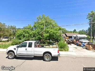
290 Pawnee Dr Boulder, CO 80303
Estimated Value: $924,030 - $1,076,000
3
Beds
2
Baths
1,722
Sq Ft
$586/Sq Ft
Est. Value
About This Home
This home is located at 290 Pawnee Dr, Boulder, CO 80303 and is currently estimated at $1,008,758, approximately $585 per square foot. 290 Pawnee Dr is a home located in Boulder County with nearby schools including Eisenhower Elementary School, Manhattan Middle School of the Arts & Academics, and Fairview High School.
Ownership History
Date
Name
Owned For
Owner Type
Purchase Details
Closed on
May 28, 1991
Bought by
Lecompte Margaret D
Current Estimated Value
Purchase Details
Closed on
Jun 18, 1984
Bought by
Lecompte Margaret D
Purchase Details
Closed on
Sep 12, 1973
Bought by
Lecompte Margaret D
Create a Home Valuation Report for This Property
The Home Valuation Report is an in-depth analysis detailing your home's value as well as a comparison with similar homes in the area
Home Values in the Area
Average Home Value in this Area
Purchase History
| Date | Buyer | Sale Price | Title Company |
|---|---|---|---|
| Lecompte Margaret D | $129,000 | -- | |
| Lecompte Margaret D | $93,500 | -- | |
| Lecompte Margaret D | $35,500 | -- |
Source: Public Records
Mortgage History
| Date | Status | Borrower | Loan Amount |
|---|---|---|---|
| Open | Lecompte Margaret D | $250,000 | |
| Closed | Lecompft Margaret D | $125,000 | |
| Closed | Lecompte Margaret D | $100,000 | |
| Closed | Lecompte Margaret D | $208,000 | |
| Closed | Lecompte Margaret D | $209,000 | |
| Closed | Lecompte Margaret D | $50,000 | |
| Closed | Lecompte Margaret D | $165,000 |
Source: Public Records
Tax History Compared to Growth
Tax History
| Year | Tax Paid | Tax Assessment Tax Assessment Total Assessment is a certain percentage of the fair market value that is determined by local assessors to be the total taxable value of land and additions on the property. | Land | Improvement |
|---|---|---|---|---|
| 2024 | $4,483 | $53,900 | $47,669 | $6,231 |
| 2023 | $4,406 | $57,714 | $55,259 | $6,140 |
| 2022 | $3,632 | $46,058 | $41,452 | $4,606 |
| 2021 | $3,463 | $47,383 | $42,645 | $4,738 |
| 2020 | $3,240 | $44,373 | $34,821 | $9,552 |
| 2019 | $3,190 | $44,373 | $34,821 | $9,552 |
| 2018 | $3,012 | $41,940 | $32,688 | $9,252 |
| 2017 | $2,918 | $46,367 | $36,138 | $10,229 |
| 2016 | $2,566 | $37,603 | $24,119 | $13,484 |
| 2015 | $2,430 | $31,792 | $14,646 | $17,146 |
| 2014 | $2,004 | $31,792 | $14,646 | $17,146 |
Source: Public Records
Map
Nearby Homes
- 4965 Ricara Dr
- 4500 Osage Dr
- 4450 Chippewa Dr
- 4800 Osage Dr Unit 4A
- 255 Kiowa Place
- 500 Mohawk Dr Unit 207
- 500 Mohawk Dr Unit 510
- 550 Mohawk Dr Unit 67
- 560 Mohawk Dr Unit 35
- 4425 Comanche Dr
- 285 Hopi Place
- 4658 Ingram Ct
- 501 Manhattan Dr Unit 202
- 4475 Laguna Place Unit 201
- 4475 Laguna Place Unit 206
- 595 Manhattan Dr Unit 203
- 5355 Kewanee Dr
- 625 Manhattan Place Unit 308
- 4500 Baseline Rd Unit 4402
- 4500 Baseline Rd Unit 3302
