


2901 Youngstown Rd Turlock, CA 95380
Estimated payment $11,112/month
Highlights
- 48.42 Acre Lot
- Fruit Trees
- No HOA
- Orchard Views
- Orchard
- Agricultural
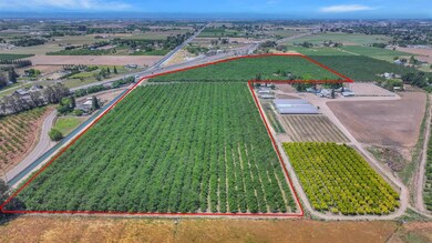
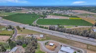
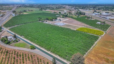
About This Lot
Approx. 48.42 acres in eleven year old producing almonds within the Turlock Irrigation District (TID). Home is fixer (3 bed/2bath). Addresses of other two parcels included are 3818 Youngstown Road and 2818 Youngstown Road. Do not disturb tenant on property.
Property Details
Property Type
- Land
Est. Annual Taxes
- $6,948
Lot Details
- 48.42 Acre Lot
- Property fronts a county road
- Irregular Lot
- Orchard
- Fruit Trees
- Possible uses of the property include Agricultural
- Property is zoned Agriculture, Agricultural,Orchard,Tree Farm,See Remarks
Additional Features
- Orchard Views
- Agricultural
- Septic Tank
Community Details
- No Home Owners Association
- Net Lease
Listing and Financial Details
- Assessor Parcel Number 044-033-005-000
Map
Home Values in the Area
Average Home Value in this Area
Tax History
| Year | Tax Paid | Tax Assessment Tax Assessment Total Assessment is a certain percentage of the fair market value that is determined by local assessors to be the total taxable value of land and additions on the property. | Land | Improvement |
|---|---|---|---|---|
| 2024 | $6,948 | $638,414 | $389,259 | $249,155 |
| 2023 | $6,936 | $625,898 | $381,627 | $244,271 |
| 2022 | $6,850 | $613,627 | $374,145 | $239,482 |
| 2021 | $6,750 | $601,596 | $366,809 | $234,787 |
| 2020 | $6,704 | $595,429 | $363,048 | $232,381 |
| 2019 | $4,944 | $435,471 | $355,930 | $79,541 |
| 2018 | $4,676 | $403,696 | $348,951 | $54,745 |
| 2017 | $4,569 | $395,781 | $342,109 | $53,672 |
| 2016 | $4,273 | $388,021 | $335,401 | $52,620 |
| 2015 | $4,238 | $382,193 | $330,363 | $51,830 |
| 2014 | $4,197 | $374,707 | $323,892 | $50,815 |
Property History
| Date | Event | Price | Change | Sq Ft Price |
|---|---|---|---|---|
| 07/15/2025 07/15/25 | Pending | -- | -- | -- |
| 06/04/2025 06/04/25 | Price Changed | $1,936,800 | -98.4% | $1,268 / Sq Ft |
| 04/12/2025 04/12/25 | For Sale | $124,824,000 | -- | $81,745 / Sq Ft |
Purchase History
| Date | Type | Sale Price | Title Company |
|---|---|---|---|
| Interfamily Deed Transfer | -- | None Available | |
| Interfamily Deed Transfer | -- | Fidelity National Title Co | |
| Interfamily Deed Transfer | -- | North American Title Company |
Mortgage History
| Date | Status | Loan Amount | Loan Type |
|---|---|---|---|
| Closed | $710,000 | New Conventional | |
| Closed | $677,625 | Commercial | |
| Closed | $475,000 | Commercial | |
| Closed | $400,000 | Commercial | |
| Closed | $720,000 | Stand Alone Refi Refinance Of Original Loan |
Source: MetroList
MLS Number: 225058160
APN: 044-33-05
Disclaimer: Certain information contained herein is derived from information provided by parties other than Homes.com. All information provided is deemed reliable, but is not guaranteed to be accurate and should be independently verified.
![]() IDX information is provided exclusively for personal, non-commercial use, and may not be used for any purpose other than to identify prospective properties consumers may be interested in purchasing. Information is deemed reliable but not guaranteed.
IDX information is provided exclusively for personal, non-commercial use, and may not be used for any purpose other than to identify prospective properties consumers may be interested in purchasing. Information is deemed reliable but not guaranteed.
- 2631 Youngstown Rd
- 18275 W Harding Rd
- 11881 Griffith Rd
- 1118 E Harding Rd
- 1412 E Glenwood Ave
- 18365 E Clausen Rd
- 2607 E Linwood Ave
- 1413 S Quincy Rd
- 0 E Linwood Ave
- 2019 Lee Rae Ct
- 439 Quarto Dr
- The Cameo Plan at Fifth Edition
- The Aspire Plan at Fifth Edition
- The Palermo Plan at Fifth Edition
- The Mystic Plan at Fifth Edition
- The Dorado Plan at Fifth Edition
- The Sienna Plan at Fifth Edition
- The Haven Plan at Fifth Edition
- 432 E Glenwood Ave
- 1165 Boxwood Way
- 400 S Laurel St Unit 400
- 2481 E Canal Dr Unit Sunshine Studio
- 312 W Main St
- 312 W Main St
- 935 Kenwood Ave
- 303 Wayside Dr
- 1749 N Olive Ave
- 275 E Minnesota Ave
- 1403 E Monte Vista Ave
- 1700 N Tully Rd
- 351 E Monte Vista Ave
- 300 Tampa St
- 3155 Niagra St
- 3155 Niagra St
- 3639 Nicole Ct
- 3701 Crowell Rd
- 4125 Pathway Ln
- 950 W Zeering Rd
- 1360 Shady Ln Unit 522
- 4389 N Walnut Rd
