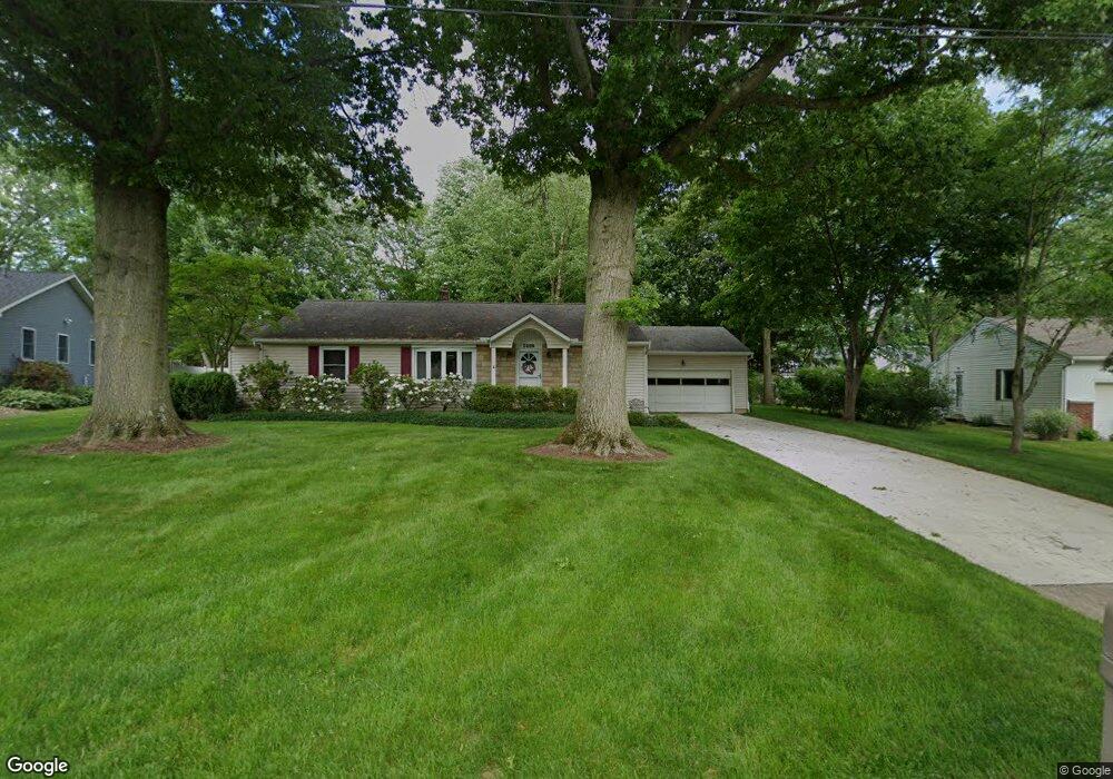
2959 Stanley Rd Fairlawn, OH 44333
Estimated Value: $285,291 - $329,000
3
Beds
3
Baths
1,654
Sq Ft
$185/Sq Ft
Est. Value
About This Home
This home is located at 2959 Stanley Rd, Fairlawn, OH 44333 and is currently estimated at $305,573, approximately $184 per square foot. 2959 Stanley Rd is a home located in Summit County with nearby schools including Copley-Fairlawn Middle School, Copley High School, and Fairlawn Lutheran School.
Ownership History
Date
Name
Owned For
Owner Type
Purchase Details
Closed on
Sep 25, 2012
Sold by
Curtis Jacqueline M
Bought by
Curtis Garrett W and Curtis Jacqueline M
Current Estimated Value
Purchase Details
Closed on
Sep 28, 1995
Sold by
Smith David J
Bought by
Curtis Jaqueline M
Home Financials for this Owner
Home Financials are based on the most recent Mortgage that was taken out on this home.
Original Mortgage
$38,000
Outstanding Balance
$277
Interest Rate
8%
Mortgage Type
New Conventional
Estimated Equity
$305,296
Create a Home Valuation Report for This Property
The Home Valuation Report is an in-depth analysis detailing your home's value as well as a comparison with similar homes in the area
Home Values in the Area
Average Home Value in this Area
Purchase History
| Date | Buyer | Sale Price | Title Company |
|---|---|---|---|
| Curtis Garrett W | -- | None Available | |
| Curtis Jaqueline M | $138,000 | -- |
Source: Public Records
Mortgage History
| Date | Status | Borrower | Loan Amount |
|---|---|---|---|
| Open | Curtis Jaqueline M | $38,000 |
Source: Public Records
Tax History Compared to Growth
Tax History
| Year | Tax Paid | Tax Assessment Tax Assessment Total Assessment is a certain percentage of the fair market value that is determined by local assessors to be the total taxable value of land and additions on the property. | Land | Improvement |
|---|---|---|---|---|
| 2025 | $3,016 | $85,117 | $19,495 | $65,622 |
| 2024 | $3,016 | $85,117 | $19,495 | $65,622 |
| 2023 | $3,016 | $85,117 | $19,495 | $65,622 |
| 2022 | $2,655 | $63,998 | $14,658 | $49,340 |
| 2021 | $2,494 | $63,998 | $14,658 | $49,340 |
| 2020 | $2,438 | $64,000 | $14,660 | $49,340 |
| 2019 | $2,489 | $59,250 | $13,920 | $45,330 |
| 2018 | $2,438 | $59,250 | $13,920 | $45,330 |
| 2017 | $2,156 | $59,250 | $13,920 | $45,330 |
| 2016 | $2,154 | $50,500 | $13,920 | $36,580 |
| 2015 | $2,156 | $50,500 | $13,920 | $36,580 |
| 2014 | $2,148 | $50,500 | $13,920 | $36,580 |
| 2013 | $2,032 | $48,300 | $13,920 | $34,380 |
Source: Public Records
Map
Nearby Homes
- 288 Kenridge Rd
- 342 S Miller Rd
- 3143 Morewood Rd
- V/L White Tail Ridge Dr
- 2520 Holgate Rd
- 595 Moorfield Rd
- 3317 Morewood Rd
- 360 Marviel Dr
- 3354 Bancroft Rd
- 804 Miramar Ln
- 0 Brunsdorph Rd
- 482 Gresham Dr
- 462 Gresham Dr
- 2385 Covington Rd Unit 402
- 2445 Chatham Rd
- 3404 S Smith Rd
- 2375 Covington Rd Unit 311
- 3475 Bancroft Rd
- 786 Brunsdorph Rd
- 1012 Bunker Dr Unit 304
- 2951 Stanley Rd
- 2967 Stanley Rd
- 278 Winchester Rd
- 268 Winchester Rd
- 288 Winchester Rd
- 2975 Stanley Rd
- 2954 Stanley Rd
- 2917 Bancroft Rd
- 258 Winchester Rd
- 2966 Stanley Rd
- 2905 Bancroft Rd
- 2935 Bancroft Rd
- 2985 Stanley Rd
- 2934 Morewood Rd
- 2978 Stanley Rd
- 244 Winchester Rd
- 2945 Bancroft Rd
- 2940 Morewood Rd
- 371 Nye Dr
- 2988 Stanley Rd