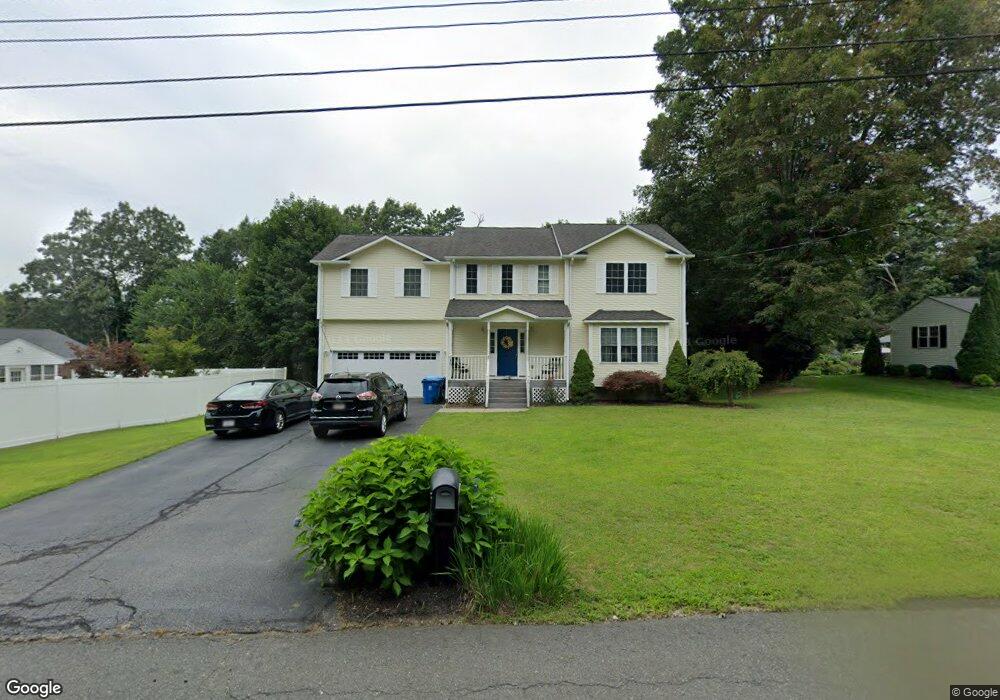
3 Bradlind Ave Wilbraham, MA 01095
Estimated Value: $508,813 - $651,000
3
Beds
3
Baths
2,336
Sq Ft
$239/Sq Ft
Est. Value
About This Home
This home is located at 3 Bradlind Ave, Wilbraham, MA 01095 and is currently estimated at $557,953, approximately $238 per square foot. 3 Bradlind Ave is a home located in Hampden County with nearby schools including Minnechaug Regional High School, St John The Baptist School, and Wilbraham & Monson Academy.
Ownership History
Date
Name
Owned For
Owner Type
Purchase Details
Closed on
May 30, 2003
Sold by
Bedrock Financial Llc
Bought by
Lopes Shirley D Savil and Lopes William P
Current Estimated Value
Home Financials for this Owner
Home Financials are based on the most recent Mortgage that was taken out on this home.
Original Mortgage
$51,300
Outstanding Balance
$22,602
Interest Rate
5.86%
Mortgage Type
Purchase Money Mortgage
Estimated Equity
$535,351
Create a Home Valuation Report for This Property
The Home Valuation Report is an in-depth analysis detailing your home's value as well as a comparison with similar homes in the area
Home Values in the Area
Average Home Value in this Area
Purchase History
| Date | Buyer | Sale Price | Title Company |
|---|---|---|---|
| Lopes Shirley D Savil | $256,500 | -- |
Source: Public Records
Mortgage History
| Date | Status | Borrower | Loan Amount |
|---|---|---|---|
| Open | Lopes Shirley D Savil | $51,300 |
Source: Public Records
Tax History
| Year | Tax Paid | Tax Assessment Tax Assessment Total Assessment is a certain percentage of the fair market value that is determined by local assessors to be the total taxable value of land and additions on the property. | Land | Improvement |
|---|---|---|---|---|
| 2025 | $8,001 | $447,500 | $61,300 | $386,200 |
| 2024 | $7,846 | $424,100 | $61,300 | $362,800 |
| 2023 | $6,987 | $382,500 | $61,300 | $321,200 |
| 2022 | $6,987 | $341,000 | $61,300 | $279,700 |
| 2021 | $6,787 | $295,600 | $65,800 | $229,800 |
| 2020 | $6,616 | $295,600 | $65,800 | $229,800 |
| 2019 | $6,446 | $295,700 | $65,800 | $229,900 |
| 2018 | $6,387 | $282,100 | $65,800 | $216,300 |
| 2017 | $6,206 | $282,100 | $65,800 | $216,300 |
| 2016 | $6,212 | $287,600 | $73,100 | $214,500 |
| 2015 | $6,005 | $287,600 | $73,100 | $214,500 |
Source: Public Records
Map
Nearby Homes
- 38 King Dr
- 5 Silver St
- 36 Maple St
- 44 Balsam Hill Rd
- 37 Balsam Hill Rd
- 80 Elizabeth Dr
- Lot 88 Turning Leaf Equinox Pass
- 474-480 Mountain Rd
- 172 Main St
- 1 Aspen Dr
- 30 Red Bridge Rd Land Lot 3
- 30 Red Bridge Rd Land Lot 1
- 30 Red Bridge Rd Land Lot 6
- 30 Red Bridge Rd Land Lot 8
- 30 Red Bridge Rd Land Lot 4
- 30 Red Bridge Rd Land Lot 5
- 30 Red Bridge Rd Land Lot 7
- 8 High Pine Cir
- 35 Lake Dr
- 16 Falcon Heights
- 5 Bradlind Ave
- 3092 Boston Rd
- 3086 Boston Rd
- 7 Bradlind Ave
- 2 Bradlind Ave
- 2 Bradlind Ave Unit 1
- 4 Bradlind Ave
- 3096 Boston Rd
- 6 Bradlind Ave
- 9 Bradlind Ave
- 3085 Boston Rd
- 8 Bradlind Ave
- 11 Bradlind Ave
- 3079 Boston Rd
- 3100 Boston Rd
- 3105 Boston Rd
- 3070 Boston Rd
- 10 Bradlind Ave
- 15 Bradlind Ave
- 13 Maynard Rd
Your Personal Tour Guide
Ask me questions while you tour the home.