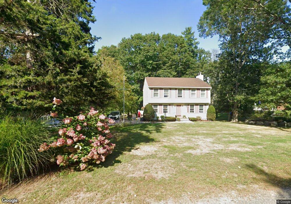
3 Mathieu Hill Rd Gloucester, MA 01930
West Gloucester NeighborhoodEstimated Value: $587,000 - $838,000
4
Beds
2
Baths
1,700
Sq Ft
$425/Sq Ft
Est. Value
About This Home
This home is located at 3 Mathieu Hill Rd, Gloucester, MA 01930 and is currently estimated at $723,343, approximately $425 per square foot. 3 Mathieu Hill Rd is a home located in Essex County with nearby schools including West Parish, Ralph B O'maley Middle School, and Gloucester High School.
Ownership History
Date
Name
Owned For
Owner Type
Purchase Details
Closed on
Aug 28, 2024
Sold by
Graham Robin
Bought by
Melanson Courtney
Current Estimated Value
Purchase Details
Closed on
Aug 1, 2024
Sold by
3 Mathieu Hill Road Rt and Graham
Bought by
Graham Robin
Purchase Details
Closed on
Jul 10, 2018
Sold by
Graham James R
Bought by
3 Mathieu Hill Nt
Purchase Details
Closed on
Mar 25, 2016
Sold by
Graham Nancy L Est and Erisman
Bought by
Graham Robin
Create a Home Valuation Report for This Property
The Home Valuation Report is an in-depth analysis detailing your home's value as well as a comparison with similar homes in the area
Home Values in the Area
Average Home Value in this Area
Purchase History
| Date | Buyer | Sale Price | Title Company |
|---|---|---|---|
| Melanson Courtney | -- | None Available | |
| Melanson Courtney | -- | None Available | |
| Graham Robin | -- | None Available | |
| Graham Robin | -- | None Available | |
| 3 Mathieu Hill Nt | -- | -- | |
| 3 Mathieu Hill Nt | -- | -- | |
| Graham Robin | -- | -- | |
| 3 Mathieu Hill Nt | -- | -- | |
| Graham Robin | -- | -- |
Source: Public Records
Tax History
| Year | Tax Paid | Tax Assessment Tax Assessment Total Assessment is a certain percentage of the fair market value that is determined by local assessors to be the total taxable value of land and additions on the property. | Land | Improvement |
|---|---|---|---|---|
| 2025 | $6,254 | $643,400 | $218,100 | $425,300 |
| 2024 | $6,207 | $637,900 | $207,700 | $430,200 |
| 2023 | $5,944 | $561,300 | $185,400 | $375,900 |
| 2022 | $5,754 | $490,500 | $161,200 | $329,300 |
| 2021 | $5,552 | $446,300 | $146,500 | $299,800 |
| 2020 | $5,523 | $447,900 | $146,500 | $301,400 |
| 2019 | $5,278 | $415,900 | $146,500 | $269,400 |
| 2018 | $5,084 | $393,200 | $146,500 | $246,700 |
| 2017 | $4,925 | $373,400 | $139,500 | $233,900 |
| 2016 | $4,829 | $354,800 | $145,500 | $209,300 |
| 2015 | $4,626 | $338,900 | $145,500 | $193,400 |
Source: Public Records
Map
Nearby Homes
- 587 Essex Ave
- 7 Leaman Dr
- 15 Lufkin Point Rd
- 368 Essex Ave
- 162 Main St
- 145 Main St Unit 1
- 145 Main St Unit 4
- 90 Southern Ave Unit 90
- 5 Samoset Rd Unit B
- 34 & 34R Pickering St
- 85 Martin St
- 167 Atlantic St
- 178 Atlantic St
- 5 Lepage Ln
- 24 Cobblestone Ln Unit 603
- 3 Hardy Ln
- 4 Tara Rd
- 145 Essex Ave Unit 402
- 226 Atlantic St
- 13 Honeysuckle Rd
Your Personal Tour Guide
Ask me questions while you tour the home.