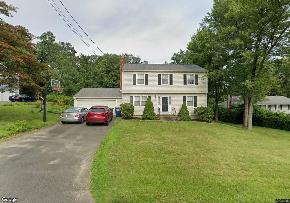
3 Ole Musket Ln Danbury, CT 06810
Estimated Value: $537,287 - $624,000
3
Beds
2
Baths
1,844
Sq Ft
$314/Sq Ft
Est. Value
About This Home
This home is located at 3 Ole Musket Ln, Danbury, CT 06810 and is currently estimated at $579,822, approximately $314 per square foot. 3 Ole Musket Ln is a home located in Fairfield County with nearby schools including Mill Ridge Primary School, Rogers Park Middle School, and Danbury High School.
Ownership History
Date
Name
Owned For
Owner Type
Purchase Details
Closed on
Dec 17, 1999
Sold by
Pearce Robert and Pearce Kimberlee
Bought by
Hall Jon B and Creiger Michelle L
Current Estimated Value
Purchase Details
Closed on
Dec 13, 1994
Sold by
Schmitt Raymond and Schmitt Sara
Bought by
Pearce Robert and Bennett Kimberlee
Purchase Details
Closed on
Aug 26, 1993
Sold by
Neaton Daniel and Neaton Kerry
Bought by
Schmitt Raymond and Schmitt Sara
Create a Home Valuation Report for This Property
The Home Valuation Report is an in-depth analysis detailing your home's value as well as a comparison with similar homes in the area
Home Values in the Area
Average Home Value in this Area
Purchase History
| Date | Buyer | Sale Price | Title Company |
|---|---|---|---|
| Hall Jon B | $240,500 | -- | |
| Pearce Robert | $192,000 | -- | |
| Schmitt Raymond | $190,000 | -- |
Source: Public Records
Mortgage History
| Date | Status | Borrower | Loan Amount |
|---|---|---|---|
| Open | Schmitt Raymond | $248,000 | |
| Closed | Schmitt Raymond | $20,000 | |
| Closed | Schmitt Raymond | $260,000 |
Source: Public Records
Tax History Compared to Growth
Tax History
| Year | Tax Paid | Tax Assessment Tax Assessment Total Assessment is a certain percentage of the fair market value that is determined by local assessors to be the total taxable value of land and additions on the property. | Land | Improvement |
|---|---|---|---|---|
| 2025 | $6,560 | $262,500 | $90,790 | $171,710 |
| 2024 | $6,416 | $262,500 | $90,790 | $171,710 |
| 2023 | $6,124 | $262,500 | $90,790 | $171,710 |
| 2022 | $5,483 | $194,300 | $87,700 | $106,600 |
| 2021 | $5,363 | $194,300 | $87,700 | $106,600 |
| 2020 | $5,363 | $194,300 | $87,700 | $106,600 |
| 2019 | $5,363 | $194,300 | $87,700 | $106,600 |
| 2018 | $5,363 | $194,300 | $87,700 | $106,600 |
| 2017 | $5,402 | $186,600 | $83,500 | $103,100 |
| 2016 | $5,352 | $186,600 | $83,500 | $103,100 |
| 2015 | $5,273 | $186,600 | $83,500 | $103,100 |
| 2014 | $5,150 | $186,600 | $83,500 | $103,100 |
Source: Public Records
Map
Nearby Homes
- 42 Miry Brook Rd Unit TRLR 27
- 94C Miry Brook Rd
- 15 Marc Rd
- 0 Ives Ct
- 2 Rolf Dr
- 1603 Briar Woods Ln
- 11 Boulevard Dr Unit 13
- 76 Old Trolley Rd
- 12 Boulevard Dr Unit 140
- 52 Langstroth Dr
- 109 Mountain Rd
- 4 Union Cir
- 5 Green Ave
- 4 Alan Rd
- 6 Advocate Place
- 12 Scuppo Rd Unit H45
- 78 Lee Ave Unit 1
- 55 Mill Plain Rd Unit 17-6
- 55 Mill Plain Rd Unit 32-17
- 95 Park Ave Unit 20