Estimated Value: $517,000 - $533,268
4
Beds
3
Baths
1,965
Sq Ft
$268/Sq Ft
Est. Value
About This Home
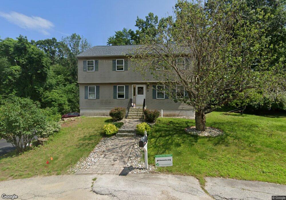
This home is located at 3 Sarah Ln, Derry, NH 03038 and is currently estimated at $526,067, approximately $267 per square foot. 3 Sarah Ln is a home located in Rockingham County with nearby schools including East Derry Memorial Elementary School, West Running Brook Middle School, and Pinkerton Academy.
Ownership History
Date
Name
Owned For
Owner Type
Purchase Details
Closed on
Sep 26, 2025
Sold by
Christmas Melissa
Bought by
5 Sarah Ln Rt and Lagana
Current Estimated Value
Purchase Details
Closed on
Sep 28, 2000
Sold by
Nourse Rtoc Rt
Bought by
Lenfest Roger and Lenfest Jennifer
Purchase Details
Closed on
Aug 11, 2000
Sold by
Sanders Robert B and Sanders Tammora J
Bought by
Bhagat Rahoul M and Bhagat Janet T
Purchase Details
Closed on
Apr 1, 1996
Sold by
Empire Mtg Lp
Bought by
Brinton James H and Brinton Paula A
Create a Home Valuation Report for This Property
The Home Valuation Report is an in-depth analysis detailing your home's value as well as a comparison with similar homes in the area
Home Values in the Area
Average Home Value in this Area
Purchase History
| Date | Buyer | Sale Price | Title Company |
|---|---|---|---|
| 5 Sarah Ln Rt | $520,000 | -- | |
| 5 Sarah Ln Rt | $520,000 | -- | |
| Lenfest Roger | $167,500 | -- | |
| Lenfest Roger | $167,500 | -- | |
| Bhagat Rahoul M | $160,000 | -- | |
| Bhagat Rahoul M | $160,000 | -- | |
| Brinton James H | $91,900 | -- |
Source: Public Records
Mortgage History
| Date | Status | Borrower | Loan Amount |
|---|---|---|---|
| Previous Owner | Brinton James H | $200,000 | |
| Previous Owner | Brinton James H | $146,800 |
Source: Public Records
Tax History Compared to Growth
Tax History
| Year | Tax Paid | Tax Assessment Tax Assessment Total Assessment is a certain percentage of the fair market value that is determined by local assessors to be the total taxable value of land and additions on the property. | Land | Improvement |
|---|---|---|---|---|
| 2024 | $8,235 | $440,600 | $0 | $440,600 |
| 2023 | $8,235 | $398,200 | $0 | $398,200 |
| 2022 | $7,606 | $399,500 | $0 | $399,500 |
| 2021 | $6,418 | $259,200 | $0 | $259,200 |
| 2020 | $6,309 | $259,200 | $0 | $259,200 |
| 2019 | $5,668 | $217,000 | $66,000 | $151,000 |
| 2018 | $5,649 | $217,000 | $66,000 | $151,000 |
| 2017 | $6,118 | $212,000 | $66,000 | $146,000 |
| 2016 | $5,737 | $212,000 | $66,000 | $146,000 |
| 2015 | $5,712 | $195,400 | $66,000 | $129,400 |
| 2014 | $5,749 | $195,400 | $66,000 | $129,400 |
| 2013 | $5,841 | $185,500 | $66,000 | $119,500 |
Source: Public Records
Map
Nearby Homes
- 114 Chases Grove Rd
- 67 & 69 Conleys Grove Rd
- 116 Chases Grove Rd
- 120 Chases Grove Rd
- 117C Chases Grove Rd
- 35 Steele Rd
- 21 Teague Dr
- 9 Valcat Ln
- Lot 22-50 Valcat Ln
- 6 Weston St
- 29 Hawk Dr
- 16 Autumn Woods Rd
- 27 Norwood Rd
- 34 Shore Dr
- 10 Independence Dr
- 20 Chandler Dr
- 69 Caddy Dr
- 60 Shore Dr
- 84 Caddy Dr
- 26 King St
- 1 Sarah Ln
- 4 Sarah Ln
- 412 Island Pond Rd Unit R
- 412 Island Pond Rd Unit L
- 410 1/2 Island Pond Rd
- 797 Haverhill Rd
- 407 Island Pond Rd
- 410 Island Pond Rd
- 410 Island Pond Rd
- 411 Island Pond Rd
- 418 Island Pond Rd
- 418 Island Pond Rd
- 418 Island Pond Rd Unit 9
- 418 Island Pond Rd Rte 111(c-599)
- 405 Island Pond Rd
- 413 Island Pond Rd
- 406 Island Pond Rd
- 141 Goodhue Rd
- 00 Route 111
- 178 Haverhill Rd