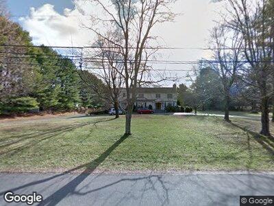
3 W Branch Rd Weston, CT 06883
Weston NeighborhoodEstimated Value: $2,435,130 - $2,820,000
2
Beds
2
Baths
--
Sq Ft
0.47
Acres
About This Home
This home is located at 3 W Branch Rd, Weston, CT 06883 and is currently estimated at $2,627,565. 3 W Branch Rd is a home located in Fairfield County with nearby schools including Coleytown Elementary School, Coleytown Middle School, and Staples High School.
Ownership History
Date
Name
Owned For
Owner Type
Purchase Details
Closed on
Jun 15, 2000
Sold by
Longstreth James
Bought by
Mccann Brian and Mccann Cynthia
Current Estimated Value
Home Financials for this Owner
Home Financials are based on the most recent Mortgage that was taken out on this home.
Original Mortgage
$600,000
Interest Rate
8.2%
Mortgage Type
Purchase Money Mortgage
Purchase Details
Closed on
Aug 1, 1997
Sold by
Homscheid Steven and Homscheid Jacqueline
Bought by
Longstreth James and Longstreth Karin
Create a Home Valuation Report for This Property
The Home Valuation Report is an in-depth analysis detailing your home's value as well as a comparison with similar homes in the area
Home Values in the Area
Average Home Value in this Area
Purchase History
| Date | Buyer | Sale Price | Title Company |
|---|---|---|---|
| Mccann Brian | $1,025,000 | -- | |
| Mccann Brian | $1,025,000 | -- | |
| Longstreth James | $775,000 | -- | |
| Longstreth James | $775,000 | -- |
Source: Public Records
Mortgage History
| Date | Status | Borrower | Loan Amount |
|---|---|---|---|
| Open | Mccann Brian R | $548,250 | |
| Closed | Longstreth James | $20,000 | |
| Closed | Longstreth James | $865,000 | |
| Closed | Longstreth James | $600,000 |
Source: Public Records
Tax History Compared to Growth
Tax History
| Year | Tax Paid | Tax Assessment Tax Assessment Total Assessment is a certain percentage of the fair market value that is determined by local assessors to be the total taxable value of land and additions on the property. | Land | Improvement |
|---|---|---|---|---|
| 2024 | $687 | $29,260 | $29,260 | $0 |
| 2023 | $968 | $29,270 | $29,270 | $0 |
| 2022 | $18,675 | $29,270 | $29,270 | $0 |
| 2021 | $964 | $29,270 | $29,270 | $0 |
| 2020 | $947 | $29,270 | $29,270 | $0 |
| 2019 | $947 | $29,270 | $29,270 | $0 |
| 2018 | $738 | $25,100 | $25,100 | $0 |
| 2017 | $726 | $25,100 | $25,100 | $0 |
| 2016 | $717 | $25,100 | $25,100 | $0 |
| 2015 | $722 | $25,100 | $25,100 | $0 |
| 2014 | $709 | $25,100 | $25,100 | $0 |
Source: Public Records
Map
Nearby Homes
- 17 Huckleberry Ln
- 48 Cavalry Rd
- 15 Arrowhead Way
- 83 Red Coat Rd
- 41 Hermit Ln
- 12 Crooked Mile Rd
- 30 Coley Dr
- 1 Crooked Mile Rd
- 87 Red Coat Rd
- 4A Newtown Turnpike
- 2 Grouse Path
- 5 Fraser Rd
- 18 Stoneboat Rd
- 70 Clinton Ave
- 3 Highwood Ln
- 9 Bobwhite Dr
- 4 Silver Brook Rd
- 83 Easton Rd
- 30 Easton Rd
- 37 Cedar Hills