
Seller's Agent in 2025
Laurie Crane
Gibson Sothebys International Realty
(617) 866-8865
1 in this area
32 Total Sales
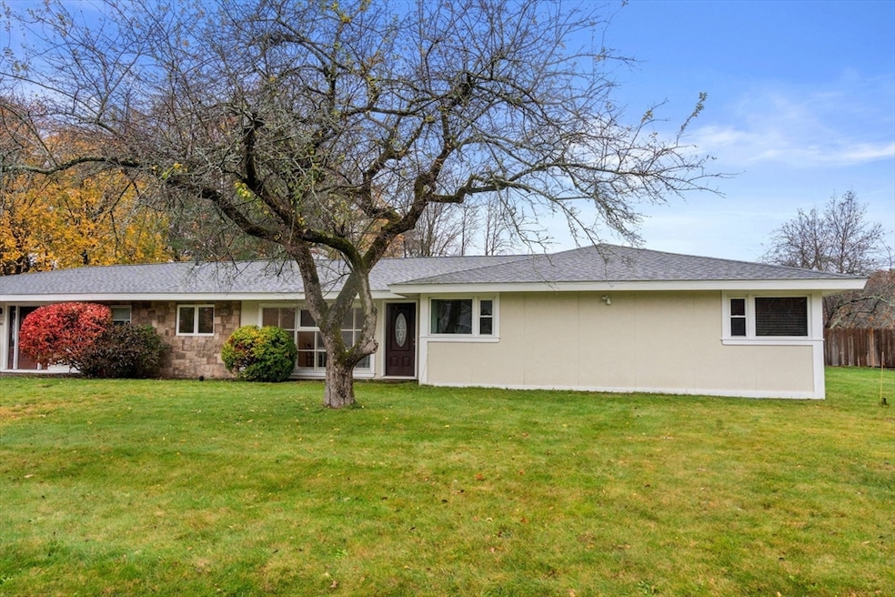


Welcome to this inviting home in the desirable Pinefield neighborhood. This move-in ready property sits on a corner lot and offers 4 bedrooms and 3 baths with flexible living spaces, all on one level. The sunny living room features a cozy fireplace, a dining area and sliding glass doors that lead to a backyard oasis complete with a deck and tranquil Koi pond. The extra large kitchen has ample counter space, cabinets galore, and a lovely adjoining area to enjoy your morning coffee. From the kitchen, French glass doors open to a 3-season sunroom. The home offers two additional versatile bonus spaces: one with a private entrance, ideal for a home office, gym, guest suite or extra storage, and the other, just off the kitchen, could be a lovely game room or additional home office. Close to schools, Saxonville shopping, Garden in the Woods and one block to the Aqueduct Trail, this great Campanelli home offers so much and has a great list price! Open houses this weekend from 12:30-2:30
Last Agent to Sell the Property
Gibson Sotheby's International Realty Listed on: 11/13/2025
Last Buyer's Agent
Jose Natal Goncalves
Mega Realty Services
| Date | Type | Sale Price | Title Company |
|---|---|---|---|
| Quit Claim Deed | $590,000 | -- | |
| Quit Claim Deed | -- | -- | |
| Land Court Massachusetts | -- | -- | |
| Land Court Massachusetts | -- | -- | |
| Land Court Massachusetts | -- | -- | |
| Land Court Massachusetts | $365,000 | -- | |
| Land Court Massachusetts | $365,000 | -- | |
| Land Court Massachusetts | $365,000 | -- | |
| Foreclosure Deed | $319,600 | -- | |
| Foreclosure Deed | $319,600 | -- | |
| Foreclosure Deed | $319,600 | -- | |
| Land Court Massachusetts | $328,000 | -- | |
| Land Court Massachusetts | $328,000 | -- |
| Date | Status | Loan Amount | Loan Type |
|---|---|---|---|
| Previous Owner | $250,000 | No Value Available | |
| Previous Owner | $200,000 | No Value Available | |
| Previous Owner | $287,600 | Purchase Money Mortgage |
| Date | Event | Price | List to Sale | Price per Sq Ft |
|---|---|---|---|---|
| 12/08/2025 12/08/25 | Sold | $590,000 | +1.9% | $241 / Sq Ft |
| 11/19/2025 11/19/25 | Pending | -- | -- | -- |
| 11/13/2025 11/13/25 | For Sale | $579,000 | -- | $237 / Sq Ft |
| Year | Tax Paid | Tax Assessment Tax Assessment Total Assessment is a certain percentage of the fair market value that is determined by local assessors to be the total taxable value of land and additions on the property. | Land | Improvement |
|---|---|---|---|---|
| 2025 | $7,468 | $625,500 | $271,100 | $354,400 |
| 2024 | $7,181 | $576,300 | $242,200 | $334,100 |
| 2023 | $6,803 | $519,700 | $216,100 | $303,600 |
| 2022 | $6,492 | $472,500 | $196,100 | $276,400 |
| 2021 | $6,307 | $448,900 | $188,500 | $260,400 |
| 2020 | $6,367 | $425,000 | $171,300 | $253,700 |
| 2019 | $6,200 | $403,100 | $171,300 | $231,800 |
| 2018 | $6,001 | $367,700 | $164,900 | $202,800 |
| 2017 | $5,857 | $350,500 | $160,100 | $190,400 |
| 2016 | $5,668 | $326,100 | $160,100 | $166,000 |
| 2015 | $5,743 | $322,300 | $160,700 | $161,600 |
Seller's Agent in 2025
Laurie Crane
Gibson Sothebys International Realty
(617) 866-8865
1 in this area
32 Total Sales
S
Seller Co-Listing Agent in 2025
Sneha Patel
Gibson Sotheby's International Realty
(781) 316-4800
2 in this area
8 Total Sales
J
Buyer's Agent in 2025
Jose Natal Goncalves
Mega Realty Services
Source: MLS Property Information Network (MLS PIN)
MLS Number: 73454515
APN: FRAM-000028-000006-003429
Disclaimer: Certain information contained herein is derived from information provided by parties other than Homes.com. All information provided is deemed reliable, but is not guaranteed to be accurate and should be independently verified.
![]() The property listing data and information, or the Images, set forth herein were provided to MLS Property Information Network, Inc. from third party sources, including sellers, lessors and public records, and were compiled by MLS Property Information Network, Inc. The property listing data and information, and the Images, are for the personal, non-commercial use of consumers having a good faith interest in purchasing or leasing listed properties of the type displayed to them and may not be used for any purpose other than to identify prospective properties which such consumers may have a good faith interest in purchasing or leasing. MLS Property Information Network, Inc. and its subscribers disclaim any and all representations and warranties as to the accuracy of the property listing data and information, or as to the accuracy of any of the Images, set forth herein.
The property listing data and information, or the Images, set forth herein were provided to MLS Property Information Network, Inc. from third party sources, including sellers, lessors and public records, and were compiled by MLS Property Information Network, Inc. The property listing data and information, and the Images, are for the personal, non-commercial use of consumers having a good faith interest in purchasing or leasing listed properties of the type displayed to them and may not be used for any purpose other than to identify prospective properties which such consumers may have a good faith interest in purchasing or leasing. MLS Property Information Network, Inc. and its subscribers disclaim any and all representations and warranties as to the accuracy of the property listing data and information, or as to the accuracy of any of the Images, set forth herein.
Ask me questions while you tour the home.