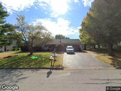
30 Sandy Ct Unit 20 Hanover, PA 17331
Estimated Value: $340,234 - $344,000
3
Beds
1
Bath
1,922
Sq Ft
$178/Sq Ft
Est. Value
About This Home
This home is located at 30 Sandy Ct Unit 20, Hanover, PA 17331 and is currently estimated at $342,059, approximately $177 per square foot. 30 Sandy Ct Unit 20 is a home located in Adams County with nearby schools including New Oxford Senior High School, St. Teresa of Calcutta Catholic School - McSherrystown Campus, and St. Teresa of Calcutta Catholic School - Conewago Campus.
Ownership History
Date
Name
Owned For
Owner Type
Purchase Details
Closed on
Oct 10, 2024
Sold by
Wolaver Deborah L and Wolaver Steve R
Bought by
Wolaver Deborah L
Current Estimated Value
Purchase Details
Closed on
Nov 17, 2005
Sold by
Messinger Lydia R
Bought by
Messinger Charles L and Messinger Deborah L
Create a Home Valuation Report for This Property
The Home Valuation Report is an in-depth analysis detailing your home's value as well as a comparison with similar homes in the area
Home Values in the Area
Average Home Value in this Area
Purchase History
| Date | Buyer | Sale Price | Title Company |
|---|---|---|---|
| Wolaver Deborah L | -- | None Listed On Document | |
| Messinger Charles L | -- | -- |
Source: Public Records
Mortgage History
| Date | Status | Borrower | Loan Amount |
|---|---|---|---|
| Previous Owner | Messinger Deborah L | $176,000 | |
| Previous Owner | Messinger Deborah L | $178,978 | |
| Previous Owner | Messinger Charles L | $68,000 | |
| Previous Owner | Messinger Deborah L | $125,000 | |
| Previous Owner | Messinger Charles L | $30,000 |
Source: Public Records
Tax History Compared to Growth
Tax History
| Year | Tax Paid | Tax Assessment Tax Assessment Total Assessment is a certain percentage of the fair market value that is determined by local assessors to be the total taxable value of land and additions on the property. | Land | Improvement |
|---|---|---|---|---|
| 2025 | $5,074 | $211,900 | $40,000 | $171,900 |
| 2024 | $4,687 | $211,900 | $40,000 | $171,900 |
| 2023 | $4,514 | $211,900 | $40,000 | $171,900 |
| 2022 | $4,376 | $211,900 | $40,000 | $171,900 |
| 2021 | $4,264 | $211,900 | $40,000 | $171,900 |
| 2020 | $4,270 | $211,900 | $40,000 | $171,900 |
| 2019 | $4,078 | $211,900 | $40,000 | $171,900 |
| 2018 | $3,992 | $211,900 | $40,000 | $171,900 |
| 2017 | $3,828 | $211,900 | $40,000 | $171,900 |
| 2016 | -- | $211,900 | $40,000 | $171,900 |
| 2015 | -- | $211,900 | $40,000 | $171,900 |
| 2014 | -- | $211,900 | $40,000 | $171,900 |
Source: Public Records
Map
Nearby Homes
- 184 St Michaels Way
- 5694 Hanover Rd
- 108 Flint Dr
- 11 Flint Dr
- 73 Flint Dr
- 65 Flint Dr
- 24 Red Stone Ln
- 54 Flint Dr Unit 50
- 41 Squire Cir Unit 25A
- 54 Red Stone Ln
- 25 Buckskin Dr Unit 73
- 9 Buckskin Dr Unit 71
- 62 Red Stone Ln Unit 43
- 17 Buckskin Dr
- 25 Warm Breeze Ct Unit 97
- 1004 Hostetter Rd Unit 265
- 240 Stafford Dr Unit 96
- 140 N Allwood Dr Unit 327
- 355 North St
- 50 Preakness St Unit 46
- 30 Sandy Ct Unit 20
- 20 Sandy Ct Unit 21
- 40 Sandy Ct Unit 19
- 65 Dakota Dr Unit 44
- 71 Dakota Dr Unit 43
- 59 Dakota Dr Unit 45
- 79 Dakota Dr Unit 42
- 53 Dakota Dr Unit 46
- 10 Sandy Ct Unit 22
- 50 Sandy Ct Unit 18
- 85 Dakota Dr Unit 41
- 31 Sandy Ct Unit 14
- 11 Sandy Ct Unit 13
- 59 Stevens St Unit 23
- 47 Dakota Dr Unit 47
- 39 Sandy Ct Unit 15
- 66 Dakota Dr Unit 151
- 74 Dakota Dr Unit 150
- 60 Dakota Dr Unit 152